wthrmn654
-
Posts
3,953 -
Joined
-
Last visited
Content Type
Profiles
Blogs
Forums
American Weather
Media Demo
Store
Gallery
Everything posted by wthrmn654
-
 Cross sound ferry has just suspended all ferry service as of 2 pm
- 246 replies
-
- 1
-

-
- heavy rain
- damaging wind? squalls?
- (and 2 more)
-
48 mph 155
-
Looking at the NWS forecast for my area, looking at the hourly#s they don't even have gusts inputted oddly enough.
-
I'm going reach out to nws thru NWSchat on slack. I agree winds are deft wilder and more potent then even i had expected.
-
Now go get dressed! Stop sitting around in your boxers
- 246 replies
-
- 1
-

-
- heavy rain
- damaging wind? squalls?
- (and 2 more)
-
Gusting 46 mph already or here as of 135 pm strongest so far. https://mesowest.utah.edu/cgi-bin/droman/meso_base_dyn.cgi?stn=F2389&unit=0&timetype=GMT
- 246 replies
-
- 1
-
-
- heavy rain
- damaging wind? squalls?
- (and 2 more)
-
Major Hurricane Melissa - 892mb - 185mph Jamaica landfall
wthrmn654 replied to GaWx's topic in Tropical Headquarters
From that jamaica webcam site only 1 of the cams is now down pretty dam impressive. -
Major Hurricane Melissa - 892mb - 185mph Jamaica landfall
wthrmn654 replied to GaWx's topic in Tropical Headquarters
Satellite estimates say 160,161 knot winds when it made landfall -
Major Hurricane Melissa - 892mb - 185mph Jamaica landfall
wthrmn654 replied to GaWx's topic in Tropical Headquarters
Quite a lot of houses in that one area. And it's about ground zero although there weather must be quite lovely at this very moment in the eye.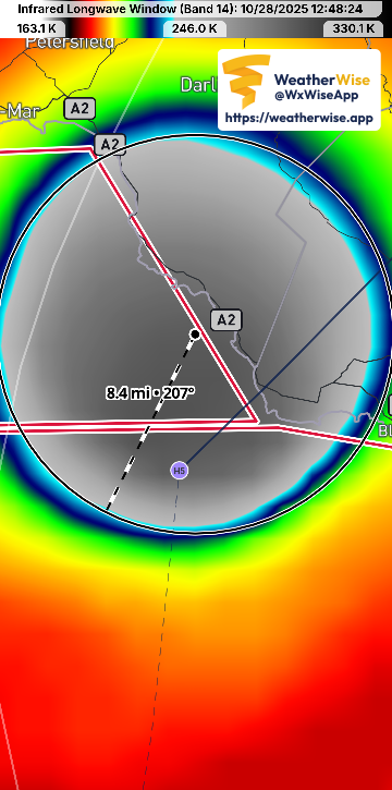
-
Major Hurricane Melissa - 892mb - 185mph Jamaica landfall
wthrmn654 replied to GaWx's topic in Tropical Headquarters
-
Major Hurricane Melissa - 892mb - 185mph Jamaica landfall
wthrmn654 replied to GaWx's topic in Tropical Headquarters
A 53rd Weather Reconnaissance Squadron crew (call sign TEAL 75), known as the Air Force Reserve Hurricane Hunters, is returning to it's forward operating location in Curaçao after encountering heavy turbulence today while entering the eye of Hurricane Melissa, a Category 5 storm. During the event, the aircraft briefly experienced forces stronger than normal due to turbulence. While this does not automatically indicate damage, standard safety procedures require an inspection before returning to operations. The 53rd WRS is an Air Force Reserve unit assigned to the 403rd Wing, Keesler Air Force Base, Miss. -
Major Hurricane Melissa - 892mb - 185mph Jamaica landfall
wthrmn654 replied to GaWx's topic in Tropical Headquarters
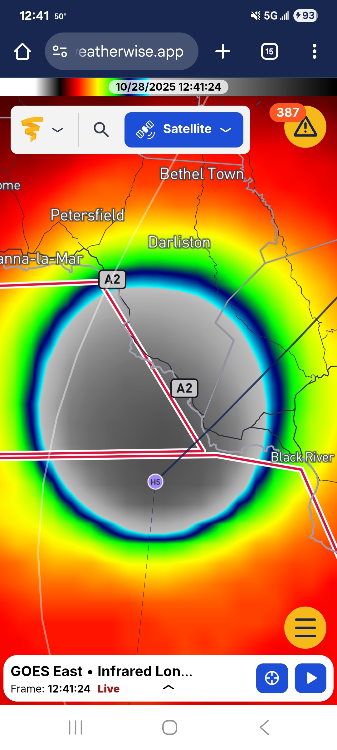
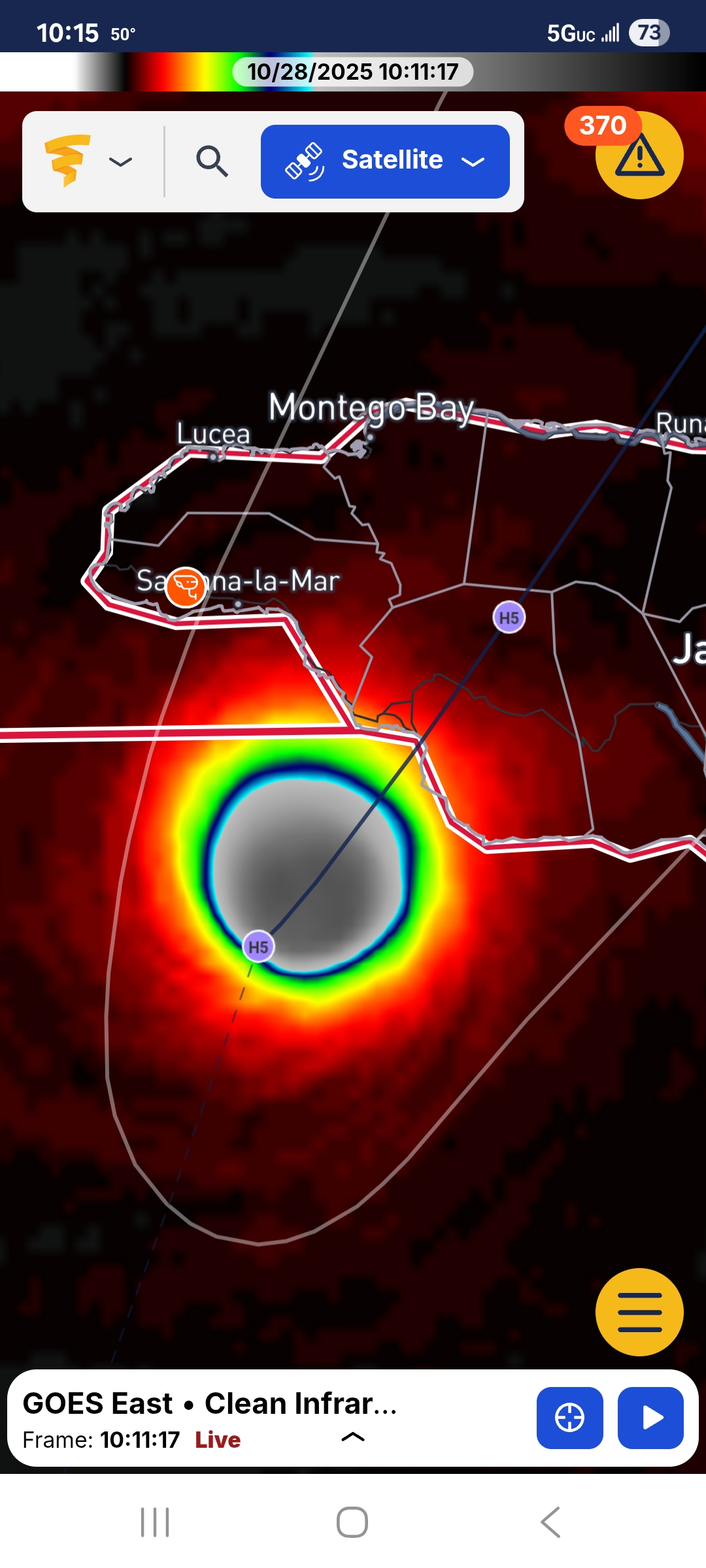
Cleanest and consistently round looking eye I've ever seen on the satellite loops that i can recall jeez -
Major Hurricane Melissa - 892mb - 185mph Jamaica landfall
wthrmn654 replied to GaWx's topic in Tropical Headquarters
The one I posted first that seems to be easier to view and ask the other sites basically show the same cams. Anyway. https://www.skylinewebcams.com/en/webcam/jamaica.html -
Major Hurricane Melissa - 892mb - 185mph Jamaica landfall
wthrmn654 replied to GaWx's topic in Tropical Headquarters
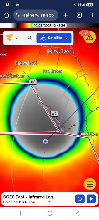
https://web.weatherwise.app/?fbclid=IwY2xjawNtr2pleHRuA2FlbQIxMQABHrZRMzPoePN58LN2fIgsBD5ByjfU_HxzDsHvXrgsWbp9NFp2KsDjVIGmU12S_aem_gG4ATJc-hpqY5SvXVUu46A#map=7/17.781/-77.309
-
Major Hurricane Melissa - 892mb - 185mph Jamaica landfall
wthrmn654 replied to GaWx's topic in Tropical Headquarters
I can see bridges under water already, https://www.skylinewebcams.com/en/webcam/jamaica.html -
Major Hurricane Melissa - 892mb - 185mph Jamaica landfall
wthrmn654 replied to GaWx's topic in Tropical Headquarters
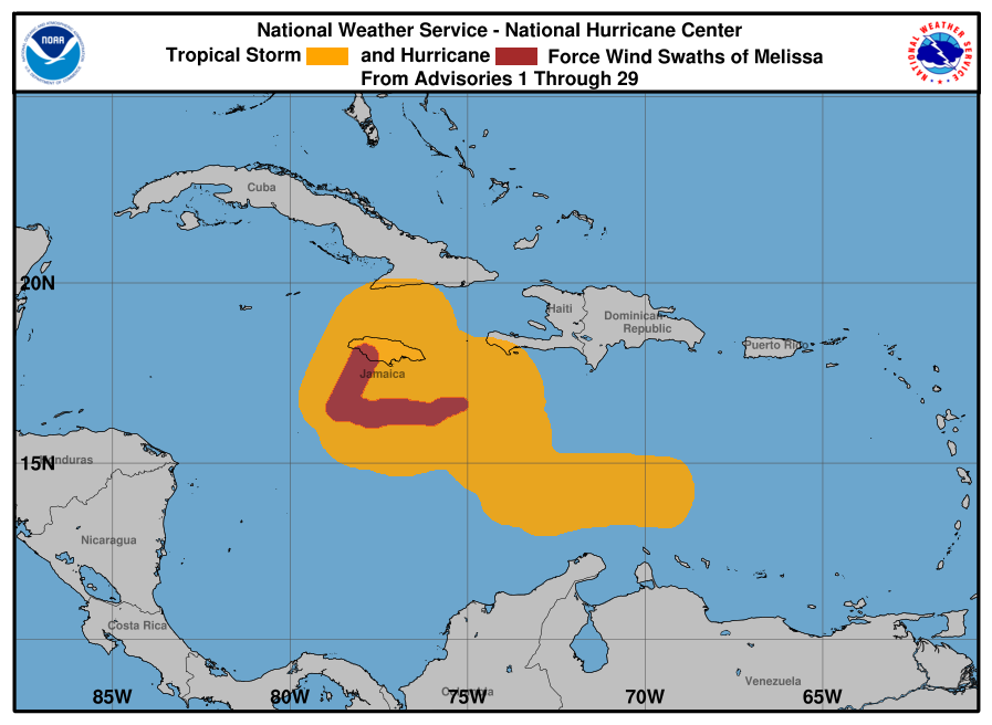
NOAA Hurricane Hunter Aircraft find that Melissa continues to strengthen with maximum sustained winds of 185 mph (295 km/h).The minimum central pressure has fallen to 892 mb (26.34 inches) based on NOAA and Hurricane Hunter Air Force Reserve aircraft data. The next update will be provided with the full advisory package at 1100 AM EDT (1500 UTC). SUMMARY OF 1000 AM EDT...1400 UTC...INFORMATION ---------------------------------------------- LOCATION...17.7N 78.1W ABOUT 45 MI...70 KM SSE OF NEGRIL JAMAICA ABOUT 255 MI...410 KM SW OF GUANTANAMO CUBA MAXIMUM SUSTAINED WINDS...185 MPH...295 KM/H PRESENT MOVEMENT...NNE OR 20 DEGREES AT 7 MPH...11 KM/H MINIMUM CENTRAL PRESSURE...892 MB...26.34 INCHES $$ -
Major Hurricane Melissa - 892mb - 185mph Jamaica landfall
wthrmn654 replied to GaWx's topic in Tropical Headquarters
Next update at 10 am from nhc any mintue -
Major Hurricane Melissa - 892mb - 185mph Jamaica landfall
wthrmn654 replied to GaWx's topic in Tropical Headquarters
Looks like after the Caribbean poor old little Bermuda will yet again see another tropical system this year. What a truly wonky year it's been. -
Major Hurricane Melissa - 892mb - 185mph Jamaica landfall
wthrmn654 replied to GaWx's topic in Tropical Headquarters
I believe she will have other factors that will help it to weaken, shear, would be the biggest one amongst other things. -
Major Hurricane Melissa - 892mb - 185mph Jamaica landfall
wthrmn654 replied to GaWx's topic in Tropical Headquarters
Can't say I've seen a storm meandering/ sit in the same region for days, to then have the ability to keep strengthening, those waters must be very warm fairly deep down? Not really familiar with that part of the world climate etc -
42 coldest yet
-
@Brian5671 don't be jealous
-

-
0.83 this morning. I win!