
.jpeg.ee54af147b498e279581e1a7251c11d3.jpeg)
Baum
-
Posts
4,013 -
Joined
-
Last visited
Content Type
Profiles
Blogs
Forums
American Weather
Media Demo
Store
Gallery
Posts posted by Baum
-
-
1 minute ago, StormChaser4Life said:
Better get out my shovel and snowblower. That cold rain is going to bury me again.
you should start the thread for the Saturday/Sunday event. Break precedent....
-
I've upgraded myself to a warning.
-
 1
1
-
 5
5
-
 1
1
-
-
20 minutes ago, cyclone77 said:
Feeling a little more confident out this way. Gonna bump my 1-3" call up to 3-4" for here/QC, with a good chance this beats our seasonal best snowfall so far (3.2"). Some decent banding may help ratios fight off the slightly warmer ground/marginal temps.
It'll be nice to see a daytime snowfall even though it may cut into amounts a bit. Seems like many events this season exclusively happened in the dark of night.
there ya go! Thinking about the same here. Might help me it'll be at night.
-
2 minutes ago, Cary67 said:
P&C went from 4-8", to 4-6", now 3-5".
Will bump my call from 2.5" to 3".
your golden.... 6" for you is my take. I'll hope for 3-4" which is the biggest event of the season.
-
Have not looked at any model runs, and not to much to glean from the discussion here, but LOT(IZZI) have pretty much made this a non-event here south of I-88. Even the heart of the I-88/290 corridor is basically a meager 1-4" forecast. The late great Jerry Taft approves.
-
1
-
1
-
-
never trust a march snowfall one way or the other.
-
was wondering if LOT might expand watches south a county or two. But I guess it's all window dressing at this point 3-6 or 6-8 I-88 and north.
-
checked on the storm thread and accidentally landed in the banter thread. I even miss Hawkeye complaining the overnight euro cut his totals in half. BTW,,,from LOT this AM:
CAN'T EVEN TOTALLY RULE OUT A
ROGUE LIGHTNING STRIKE OR TWO LATE THURSDAY AFTERNOON INTO
THURSDAY EVENING.-
1
-
1
-
-
2 minutes ago, mimillman said:
18z Euro picking up a lake enhancement signal it hasn’t had on prior runs
this is our moment.
-
1
-
-
52 minutes ago, hawkeye_wx said:
While there has been a general weakening/drying trend across the board, the Euro is way drier than all other models (1/3 to 1/2).
Look at this.... the Euro vs GFS, only two days away from the event. Seriously, wtf?!?
this is and always was a standard advisory level event at 3-6". Thinking a model showing a 12" snowfall 4-5 days out is fools gold, and has always been. Problem is, we post and follow them so when reality sets in were disssapointed. And I will push back on it's been a winter of events trending south and dryer. It's been a non winter south of Wisconsin and Michigan.Not one event has run the corridor from Iowa through Northern Ohio with a standard 3-6" advisory snow this winter. However, I can tell you that Milwaukee, less than an hour from my back yard had a 8" snowfall on1/29(this also hit most of far north Ill incl Mchenry county), a 6" snowfall on 2/17, and a 3-4" sleet/snow event on 2/22-23. Heck, less than 5 days ago we had a huge intense cutter through the midwest. They don't always work out for your backyard. It's just been a bad winter for the zone mentioned previuosly. But who knows maybe this one will surprise. If not, the grass will green up, the days are longer, birds are chirping at 5 am, green is poking out of the ground, and baseball is being played in florida and arizona. I love the transition to spring as well.
-
6
-
 1
1
-
-
3 minutes ago, A-L-E-K said:
final call 3"
biggest event of the year if it verifies.
-
might be the first real spread the wealth event that includes the Iowa/N. IL/N. IN/N. Ohio trek all winter minus the pre Christmas Arctic wave. Shame ratios will be pretty rough. But based on 12Z runs time to get invested.
-
2
-
-
9 minutes ago, OrdIowPitMsp said:
Looks like MPX isn’t messing around with a WSW already posted for 4-7” meanwhile the graphic shows 6-12”
call me surprised. By March in 2014,here, I feel like the NWS basically gave up on watch/warning issuances as the public was somewhat numb.
-
1
-
-
looks lame. But 3" of slush would be the event of the season here. Not a joke.
-
27 minutes ago, OrdIowPitMsp said:
North, South, East, West. There really isn’t a direction this thing can trend away from MSP.
Ready 2b buried
sometimes they just go poof.
-
3
-
-
Alek to douse the flames of this thread in 3...2....1.....
-
1
-
2
-
-
2 hours ago, Malacka11 said:
We gonna make a thread for the 9th-10th or...
can we just do pictures instead of words to name it?
.jpeg.4a37f05b4275d794a731c9d655e19fb9.jpeg)
-
6
-
-
On 3/1/2023 at 12:31 PM, Stebo said:
Bowme has been right here for years under another account.
and a different social media presence as well. Cause Bowme cut hard. Dude, incited near riots on the board,back in the day. Usually between midnight and 6am. It was always fun to follow the crap he started, and see folks engage, and than he usually got banned for a couple weeks. Good times.
-
1
-
1
-
-
7 minutes ago, Malacka11 said:
Coping hard but we got an interesting sunset out of it at least over here. The edge of the cloud deck is visible to the west with blood orange skies beyond. It's the little things
see you in the short-med range thread to chase the next kick to the balls.
-
2
-
5
-
-
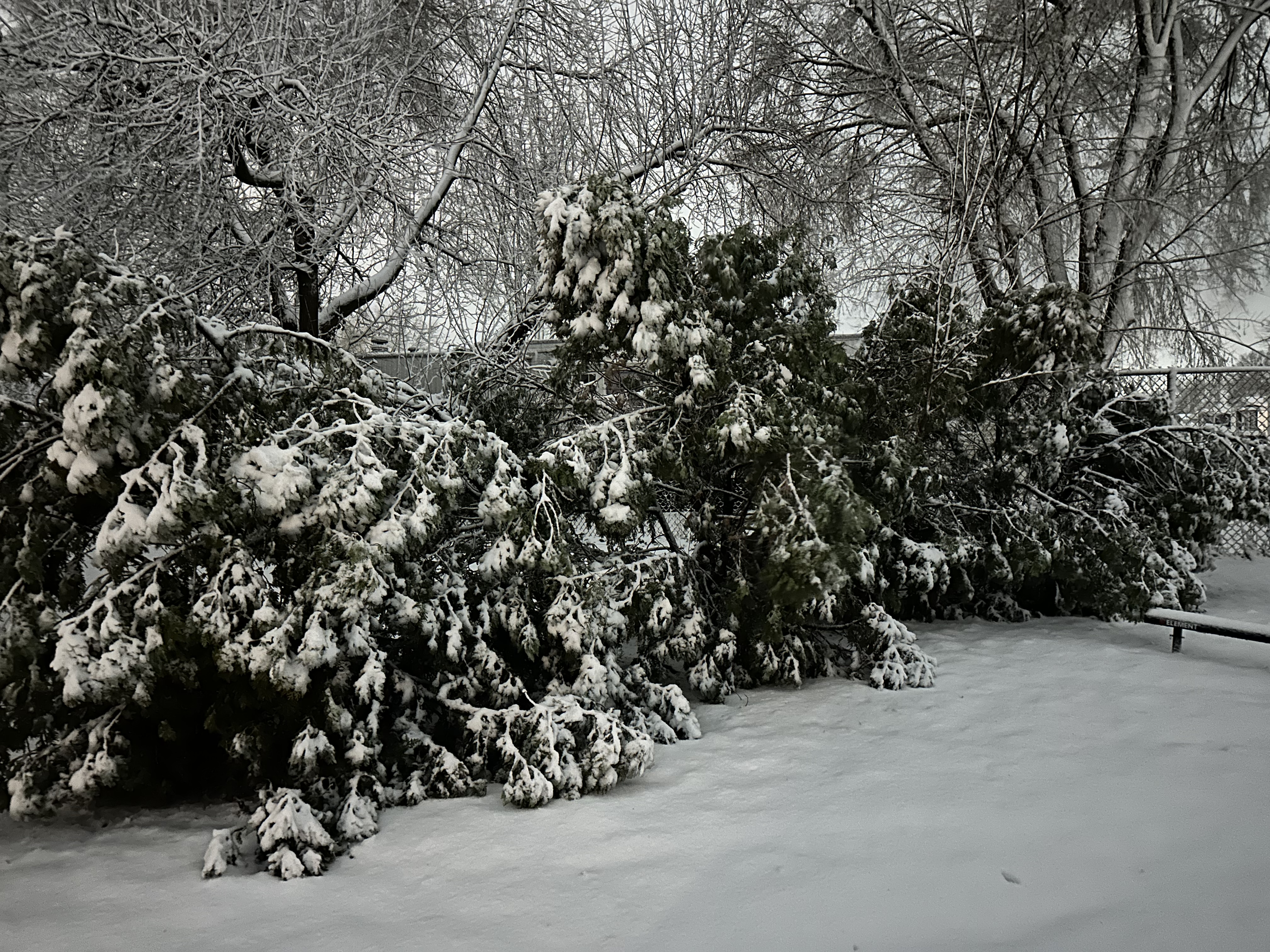
6 minutes ago, SolidIcewx said:
These arborvitae are trashed lol
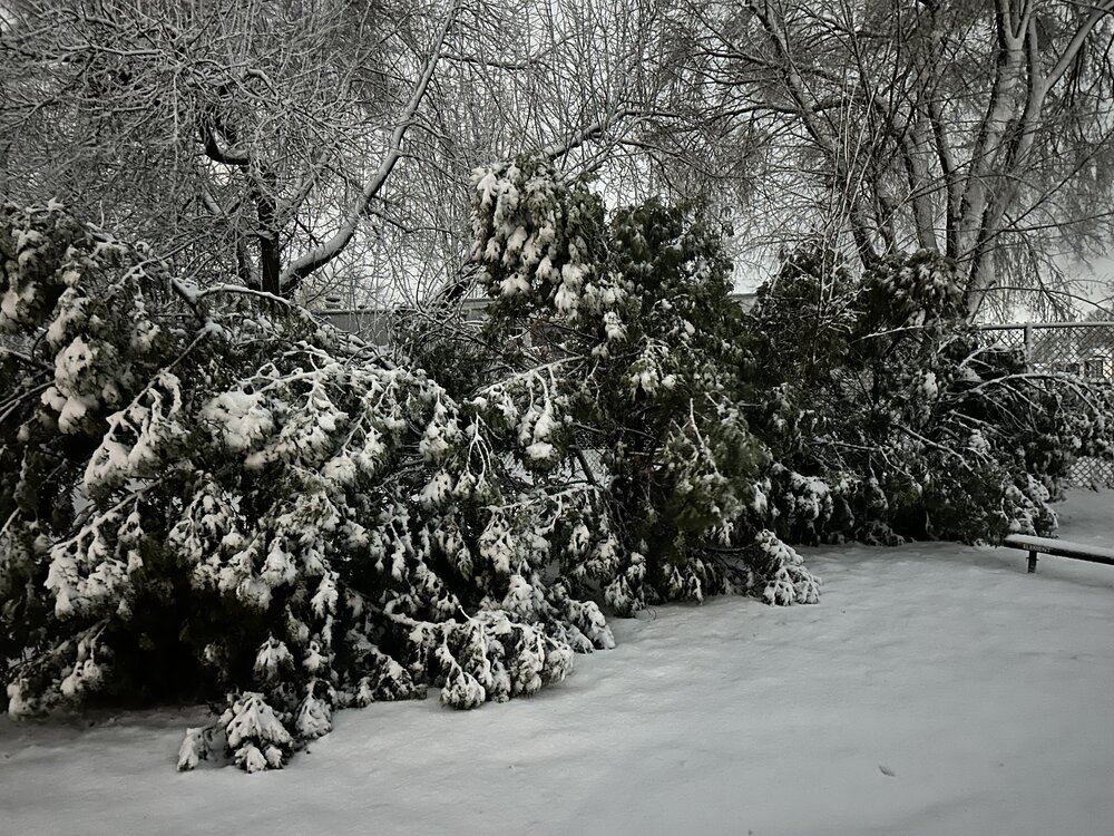
you just made me feel better on missing this. Looks like Thanksgiving 2018 at my place. You can keep that damage.
-
1
-
-
The guy that told me I'd be smoking cirrus yesterday busted bad. Have a thick overcast with a flake or two flying in the air.
-
4
-
-
22 hours ago, A-L-E-K said:
A brutal miss incoming
confirmed.
-
1
-
 1
1
-
-
1 minute ago, RCNYILWX said:
Temps and dew points are solid above the colder guidance. Looking problematic for any accums in our IL counties and even NW IN will probably underperform unless it absolutely rips this afternoon following changeover.
Strengthening east northeast flow may help bring in slightly lower dew points and help there, but especially IWX CWA. Up here in the metro, there's forecast to be strong lift in the DGZ, though strong subsidence and some drying in the lower levels northwest of the f-gen banding, per forecast soundings.
Sent from my SM-G998U using Tapatalk
Courageous of you to give us our post mortem. As said by many, it is a pleasure to get your insights as we follow an event like this. Oh, what might have been. Still think another shot at a decent event lurks for this area this season.
-
3
-
-
1 minute ago, NYC10023 said:
2 pages of model discussion and not 1 screenshot of said models to visualize what is being discussed. This sub forum would be so much better if these were attached.

because the time for posting models has passed. It's nowcast time pretty much. And frankly, if I see another model run after the last 5 days with this event I might wretch.
-
1
-
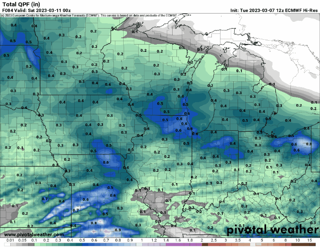
March 9-10 Winter Storm
in Lakes/Ohio Valley
Posted
looks like it should be snowing, but it's not.