
.jpeg.ee54af147b498e279581e1a7251c11d3.jpeg)
Baum
-
Posts
4,013 -
Joined
-
Last visited
Content Type
Profiles
Blogs
Forums
American Weather
Media Demo
Store
Gallery
Posts posted by Baum
-
-
17 minutes ago, ILSNOW said:
6z Euro


-
 1
1
-
-
compromise solution:

-
4 minutes ago, SolidIcewx said:
Sorry Baum I need to barrow this

it works since I think this is a 5-10" heavy wet snow on a classic axis of KC-CHGO-DET.
-
2
-
-
5-10" heavy wet snowstorms that bisect the Chicago metro are standard fare in late winter and early spring. One of my favorite cement events:

-
2
-
-
post 12Z runs:

-
2
-
-
the Baum Model at 06Z: consistent, to say the least.

-
1
-
-
Post 12 Z model run update:

-
2
-
-
quality lightning and thunder here. Nice CG strike as I was taking out the trash. Time to change the boxers. Little to much drama for a monday morning.
-
 3
3
-
-
Looks like the NE may finally get a snowfall.
-
overnight update:

-
I miss the DGEX
-
2
-
2
-
-
-
3 minutes ago, Stevo6899 said:
I was hoping you'd be on top of things and started the thread before hoosierdaddy. Still ridin high from the Jan 25 storm thread.
I normally don't bite on thread starting until the JMA comes on board.
-
1
-
2
-
-
Been busy. Just took a quick gander at the GFS and think that's the way to go on this one.
-
2
-
1
-
-
Bullseye. I'll be hittin the grocery store to stack up on food staples and TP. for this one.
-
1
-
1
-
-
TONIGHT
MOSTLY CLOUDY WITH A 20 PERCENT CHANCE OF SNOW
SHOWERS.THIS NARROW, BUT RATHER INTENSE, BAND OF SNOW WILL LIFT NORTH
ACROSS THE AREA NORTHERN ILLINOIS AND NORTHERN PORTIONS OF LAKE
AND PORTER COUNTIES OVER THE NEXT COUPLE/FEW HOURS.Update: REST OF TONIGHT
CLOUDY. A CHANCE OF LIGHT SNOW LATE IN THE
EVENING, THEN A SLIGHT CHANCE OF LIGHT SNOW AFTER MIDNIGHT.
DUSTING TO A HALF INCH OF ACCUMULATION. LOWS IN THE MID 20S. EAST
WINDS 5 TO 10 MPH LATE IN THE EVENING, BECOMING SOUTH AFTER
MIDNIGHT. CHANCE OF PRECIPITATION 50 PERCENT.this is already wrong. Izzied.
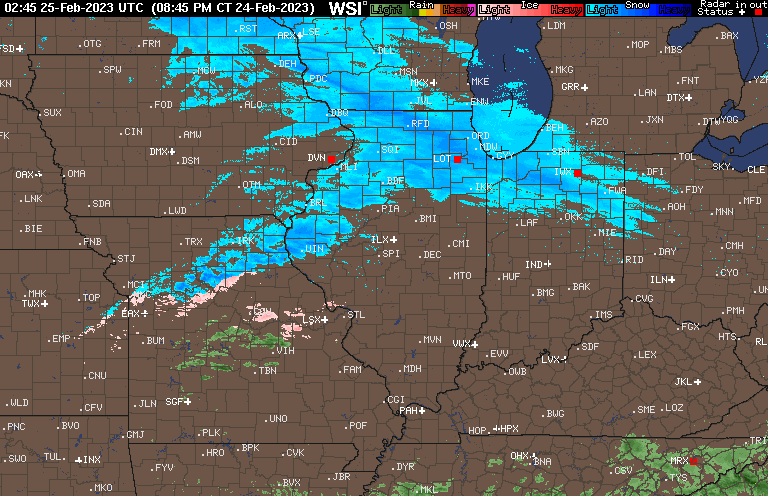
If your in the snow and ice business this type of blown call is frustrating. Snowing nicely in Dupage County and all roads covered. Suspect on a Friday night with no real expectation for travel impacts based on forecasting this will create some issues.
-
3 hours ago, Hoosier said:
Not a bad GFS run for the sub.
can someone post the "hello darkness my old friend meme". Thanks in advance.
-
38 minutes ago, weatherbo said:
Will reintroduced himself as Alyssa a couple years ago then never came back.
heard she moved to the UP
-
9 hours ago, ChiTownSnow said:
Not sure where to post. But thought it was worth a share
https://www.facebook.com/100044248578383/posts/830163671801911/?flite=scwspnss
Not surprising. And the '80's-'90's decades were extremely poor compared to recent, as depicted. And things can change in a hurry as Milwaukee can attest. They have had a 8",6", and 4" sleet storm in the past 25 days.
-
 1
1
-
-
Michigan is going to be ugly.
-
30 minutes ago, A-L-E-K said:
Dry fropa, sad times
30 minutes ago, A-L-E-K said:Dry fropa, sad times
Radar still looks a bit sketchy, though they tend to explode in set ups like this. I see LOT took the bait and brought the freezing rain line south a touch. Big worry with this is robbing of moisture transport from gulf convection.
-
Things I never thought i'd see. Hardy Palm weenied by Alek for complaining Ice Storm Warnings issuances are too narrow.
-
1
-
6
-
-
44 minutes ago, Natester said:
As expected, 12z EURO a tick to the south, but not by much. With forecast temps at 31-32F, much of it is going to run off.
let us know if your power goes out.
-
42 minutes ago, hardypalmguy said:
Ice is south, snow is north. What's left?
here is your answer:
PRECIP TYPE WILL STILL BE VERY TRICKY. THIS LOOKS LIKE A
WIDESPREAD SLEET EVENT FOR MOST.-
1
-
3
-

March 3-4 Potential Winter Storm
in Lakes/Ohio Valley
Posted
for the naysayers:
https://wgntv.com/weather/weather-blog/the-major-st-valentines-day-snowstorm-of-1990/