
.jpeg.ee54af147b498e279581e1a7251c11d3.jpeg)
Baum
-
Posts
4,014 -
Joined
-
Last visited
Content Type
Profiles
Blogs
Forums
American Weather
Media Demo
Store
Gallery
Posts posted by Baum
-
-
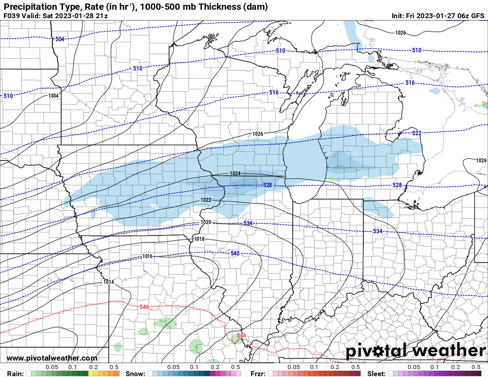
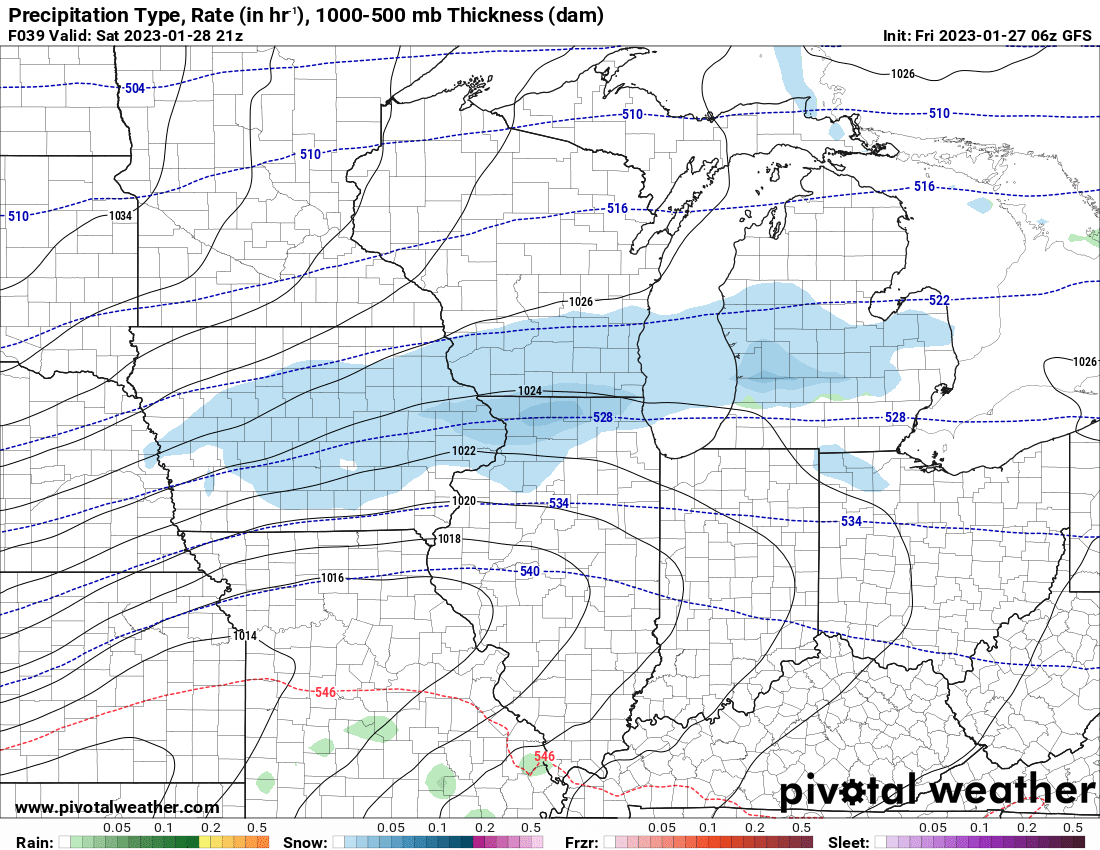
4 hours ago, hawkeye_wx said:
The 00z Euro did become stronger and snowier compared to the 12z run. Of course, this will be very wet, low-ratio snow, and if the Euro is too cold by a degree this forecast will bust. This is the snowiest of all the models this evening. I would err on the low side. DVN, this afternoon, said not much snow south of Waterloo-Dubuque. That's certainly possible.
I can't help but get a bit angry because we finally get a rare, strengthening low, loaded with moisture, tracking from St. Louis to Chicago (maybe once every few years track) and there is no f'ing cold air.... in early February. 19 times out of 20 this is a big snowstorm.

what he said.
-
 1
1
-
 1
1
-
-
Beavis's summer home.
-
4
-
 2
2
-
-
7 minutes ago, A-L-E-K said:
zzzzzzz

yeah. it's bad. and you know the pattern will flip cold and wet in mid march through may,
-
2
-
-
10 hours ago, ChiTownSnow said:
So they say.
Just because it missed us to the east with it's main accumulations does not it mean it didn't happen. Could also add one of the most impactful 1-3" snows given the wind and cold associated with it over a wide area I've seen in some time. So of course, it leaves us with;what could have been.
-
3 hours ago, Chicago Storm said:
don’t waste your time.
.3 hours ago, ChiTownSnow said:after the time wasted on the Christmas "blizzard" this is nothing..
the December event was in a pattern conducive for possible snowstorm. The pattern here is conducive for showers and thunderstorms.
-
9 hours ago, Baum said:
here is another example of bullshit NWS forecasting out of Milwaukee:
TONIGHT
SNOW. SNOW ACCUMULATION OF 2 TO 5 INCHES. TOTAL SNOW
ACCUMULATION 2 TO 8 INCHES. NEAR STEADY TEMPERATURE AROUND 18.
NORTH WINDS 10 TO 15 MPH. CHANCE OF SNOW NEAR 100 PERCENT.this is embarrassing. I'm sorry, you just cannot pull this stuff. What happend to forecasting, and if you bust...own it?
MILWAUKEE-
INCLUDING THE CITY OF MILWAUKEE
331 AM CST SUN JAN 29 2023
...WINTER STORM WARNING IN EFFECT UNTIL 6 AM CST EARLY THIS
MORNING...
EARLY THIS MORNING
SNOW SHOWERS LIKELY. NEW SNOW ACCUMULATION
UP TO 1 INCH. TOTAL SNOW ACCUMULATION 1 TO 5 INCHES. NORTH WINDS
15 TO 20 MPH. CHANCE OF SNOW 70 PERCENT. -
easy F. Even this weeks supposed cold is lame.
-
12 minutes ago, mimillman said:
I wasn’t here for 2011-2012 but this may look to beat that one in terms of futility
no worries, I'm sure we'll have a number of baroclinic frontogenesis systems that will perform.
-
MCHENRY-
INCLUDING THE CITIES OF CRYSTAL LAKE, ALGONQUIN, MCHENRY,
AND WOODSTOCK
912 PM CST SAT JAN 28 2023
..WINTER STORM WARNING IN EFFECT UNTIL 3 AM CST SUNDAY
REST OF TONIGHT
SNOW AND A CHANCE OF FREEZING RAIN LATE IN THE
EVENING, THEN SNOW LIKELY AND A CHANCE OF FREEZING RAIN AFTER
MIDNIGHT. PATCHY BLOWING AND DRIFTING SNOW. SNOW ACCUMULATION
AROUND AN INCH. NEW ICE ACCUMULATION AROUND A TRACE. LOWS AROUND
17. NORTHEAST WINDS 10 TO 15 MPH. CHANCE OF PRECIPITATION NEAR
100 PERCENT. -
here is another example of bullshit NWS forecasting out of Milwaukee:
TONIGHT
SNOW. SNOW ACCUMULATION OF 2 TO 5 INCHES. TOTAL SNOW
ACCUMULATION 2 TO 8 INCHES. NEAR STEADY TEMPERATURE AROUND 18.
NORTH WINDS 10 TO 15 MPH. CHANCE OF SNOW NEAR 100 PERCENT.this is embarrassing. I'm sorry, you just cannot pull this stuff. What happend to forecasting, and if you bust...own it?
-
1
-
-
as of now have not heard one impressive total out of this. We've learned to appreciate water out of a turnip. And radar doesn't really depict a big influx for a dramatic uptick.
-
in Beer Town. Bring it.
-
radar giving us any clue yet on jackpot zones? screwed zones?
.gif.02e1aeb9a0a4a904597ab9f62e654db0.gif)
-
"AS WHAT APPEARED SEVERAL DAYS AGO COULD BE A
CONTINUED ACTIVE PATTERN LOOKS DECIDEDLY LESS SO NOW." as taps plays in the background. -
12 minutes ago, cyclone77 said:
18z Euro bumped south a decent amount.
it's taken 3 years but the 18Z Euro bumping south is suddenly a win. Where's Chicago Storm when you need him?
-
1
-
1
-
-
34 minutes ago, Hoosier said:
All things considered, it seems reasonable enough. Tricky call for them, but at some point you have to make one. Can't punt forever.
unfortunately, i have seen how these bands play out historically here. But obv rooting for the southern outcome.
-
LOT Goes WWA for 3-6 I-88 and north
-
Just now, Malacka11 said:
This squall is without a doubt the event of the season so far.
yup. whipping snow.
-
1
-
-
thinking LOT goes with a Coin Flip Watch for this scenario?
-
maybe my skepticism can score us a coup.
-
Sorry, looks about right. And this one looks especially fickle with small narrow band.
-
2 minutes ago, A-L-E-K said:
About to crush b2b calls
actually I think this would be your 5th straight correct call. Lowballing all events 5 days out has been a winning move for some time now.
-
2
-
-
On 1/24/2023 at 1:11 PM, sbnwx85 said:
Definitely the most active pattern since November in these parts. Four inches tomorrow, 1" Thursday, 1" Friday and possibly 4" Saturday night/Sunday. It won't be 10" on the ground due to compaction but it'll at least look like a proper January. And the extended looks good too.
7 hours ago, mimillman said:Outside of an overperformer this weekend, what could have been a promising stretch has been lackluster. The extended looks wholly unremarkable
huh
-
1
-
-
2 hours ago, tuanis said:
This kind of system can be our bread & butter up here. Hope it delivers. The fronto band can really dump, but often seems to drift further north than anticipated instead of sitting overhead. Fingers crossed.
proof lack of snow has an impact on a snow weenies mental make up.

February 8-9 Should There Be a Thread For This Storm
in Lakes/Ohio Valley
Posted
if only it was that easy.