
.jpeg.ee54af147b498e279581e1a7251c11d3.jpeg)
Baum
-
Posts
4,013 -
Joined
-
Last visited
Content Type
Profiles
Blogs
Forums
American Weather
Media Demo
Store
Gallery
Posts posted by Baum
-
-
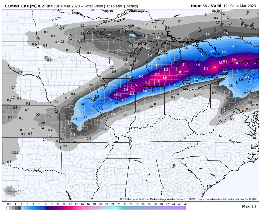
overnight update:
.jpeg.d28a5e258dd9b1c4ff284254cdaa5b3a.jpeg)
-
 6
6
-
-
forced into the medium range thread after another swift boot to the mid section. Oddly, it's much easier to overcome March disappointments than mid winter. Rumor is cold is on the table. Shocker.
-
 1
1
-
-
I see LOT decided to issue warnings/advisories prior to rest of overnight runs. I don't disagree with calls, and really don't put much credence in winter weather products, but surprised this move was made now.
-
Just now, SolidIcewx said:
As I’ve said before the sun shines on a dogs ass once in awhile

like the Hoosier reference, as we enter March.
-
1
-
-
Last model run I'll see tonight. Not in the jackpot. But like where I sit. Chicago metro will be bi - sected with heaviest to the south and east versus other events this year that favored north and west.
-
3
-
-
3 minutes ago, King James said:
Chicago crew cancelling storms that just miss them is one of my favorite parts of this sub.
Historical knowledge says cancel at your own risk.
-
1
-
-
1 minute ago, Malacka11 said:
The HRRR is bumping north slowly too if anyone cares
at this point wake up in the morning and watch the radar, my friend. It should be a beautiful presentation. As Joe Strummer once sang it's going to be "Death or Glory."
-
 1
1
-
-
2 minutes ago, SchaumburgStormer said:
And as is the norm lately, those in the "bullseye" will end up disappointed by underperformance due to the terrible modeling.
as they say,"if the ships going down your going to come with me." post. Cary's congratulatory tone to those in the bullseyes was all BS. Every true snow weenie knows it.
-
1
-
-
14 minutes ago, Chicago Storm said:
18z NAM will be SE, so there’s that.
.i'm okay with it.
-
1
-
-
1 minute ago, MidwestChaser said:

stole my programming. But love the new avatar. As they say, "shock me" or is it "snowblind"?
-
8 minutes ago, Chicago Storm said:
ya’ll are overusing the “lock of the week” meme.
.No worries. I have another one ready in the event of the inevitable.
-
1
-
-
13 minutes ago, Malacka11 said:
Glad you're still with me <3
As long as that band is modeled within 50-100 miles,esp SE, I refuse to bail. Way too many times seen those LP's coming up like that pull NW or throw moisture further back than modeled. Prepared to go down with the ship, as they say. It's not all models, to me. Climo and history play a part as well. Suspect the NAM will cave southeast as well here soon. But until I see the whites of it's eyes on radar presentation tommorow morning going to have stay the course.
-
6
-
-
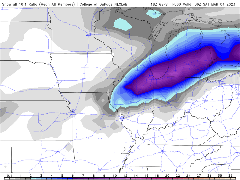
post 12Z model update:

-
1
-
-
memories of a march storm in the 1990's comes to mind. Call was for 1-2" on grassy areas. By mid day parachutes were falling with thunder and got about 6-8" in several hours. One of my favorite busts. Has all the earmarks.
-
3
-
-
-
5 minutes ago, Lightning said:
The one thing I like about this storm is the potential for few good hours of 2"/hour rates.
from Northern Ind. office:
WHERE SNOW FALLS FRIDAY, RATES COULD
REACH 3" PER HOUR.-
2
-
 1
1
-
-
14 minutes ago, A-L-E-K said:
there it is. running late today.
-
overnight update:

-
3
-
-
-
20 minutes ago, Frog Town said:
Got lots of laughs when posted but now it's not so funny. When you've seen this happen so many times over the Winter, it doesn't take a MET degree to catch on.
.thumb.png.f5cb2841386ee07e4f97b29acdf32011.png)
-
-
17 minutes ago, RCNYILWX said:
With all due respect, describing it that way makes it seem like there's a predetermined outcome. If your take is that the snow swath will end up south of what the 12z Euro op is showing, that's fine. There's no such thing as a model moving toward a consensus. Plus, the GEFS mean is solidly north of the GFS. And the amount of spread in the solutions means there isn't a consensus anyway.
not to take away from your post but I believe the GFS consensus from a day ago is now where the Euro consensus is today.
-
53 minutes ago, Chicago Storm said:
people should have never gotten invested several days out from a thread the needle potential in a not so great pattern in the first place.
can't resist. Post 12Z model update:

-
20 minutes ago, Lightning said:
It is obvious that the excitement of this storm is greatly diminishing in this thread.

People are scared is all.
.png.197bd6b2221bfb6f66a43f65e6ad29d4.png)
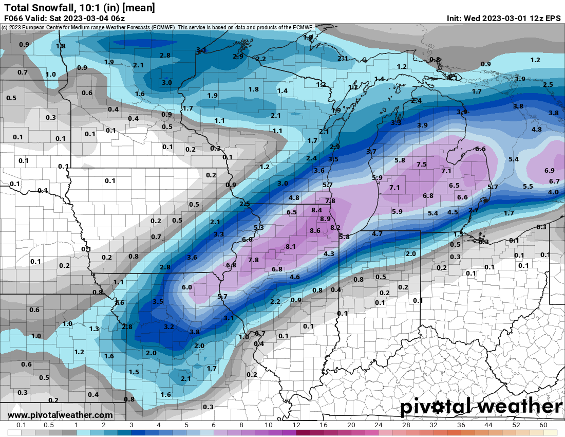
.png.9c8abed2cdac250c5fc8102c1c3ee196.png)

March 3-4 Potential Winter Storm
in Lakes/Ohio Valley
Posted
i did.