-
Posts
4,017 -
Joined
-
Last visited
Content Type
Profiles
Blogs
Forums
American Weather
Media Demo
Store
Gallery
Posts posted by Baum
-
-
4 minutes ago, SchaumburgStormer said:
LOT:
"There are other factors, though, that could play a role in limiting how much snow we`ll get compared to what most model guidance is currently advertising, including the aforementioned dry slot preventing complete saturation of the dendritic growth zone (resulting in poorer quality snowflakes and lower snow-to- liquid ratios) and the possibility of convection to our south limiting much moisture will reach our latitude. Also worth noting is that setups similar to this one featuring a positively-tilted trough and a not overly deep low have also underperformed here in the past when other mitigating factors such as dry slots and moisture robbing have been involved."
LOT with standard CYA jargon. There is a caveat with virtually any set up. Throw down your cards and play or leave the table.
-
-
we will see how today's models pan out. But sadly, this is could be the event of the season for MBY....................

-
Just now, Hoosier said:
Nice of it to finally start to wake up.
showed quite a bit of ice i think as well.
-
-
30 minutes ago, Hoosier said:
Somebody stop me... but I'm actually getting just a little bullish on this one especially in the northern 1/2 or so of the metro.
It appears like there will be a period of decent rates and temps may fall below 30 during that time. This would help to counteract the recent warmth. I could imagine advisory snowfall amounts south of where LOT currently has the watch.
DuPage County:
THURSDAY
RAIN, FREEZING RAIN, SNOW AND SLEET LIKELY IN THE
MORNING, THEN SNOW, A SLIGHT CHANCE OF RAIN AND FREEZING RAIN IN
THE AFTERNOON. SEVERAL INCHES OF ACCUMULATION POSSIBLE. ICE
ACCUMULATION AROUND A TRACE. BLUSTERY WITH HIGHS IN THE LOWER
30S. NORTHEAST WINDS 15 TO 25 MPH WITH GUSTS UP TO 35 MPH. CHANCE
OF PRECIPITATION 90 PERCENT.LOT thinking same it seems. Guessing LOT/MKE didn't see eye to eye on WSW issuance. Milwaukee going 5-7 in SE Zones yet no watch. Interesting.
-
1 minute ago, madwx said:
18Z NAMs say wagons south
has always been weak and south...no?
-
6 minutes ago, A-L-E-K said:
miss north
the disappearance of Hardy Palm guy confirms
-
 2
2
-
 5
5
-
-
LOT issues a WSW for northern tier of counties. Board shrugs.
-
 2
2
-
-
-
the take outta beer town:
THE ONE CAVEAT IS THERE HAS BEEN A TREND FURTHER SOUTH AND IF
THIS TREND CONTINUES WE COULD SEE LESS AND LESS SNOW POTENTIAL IN
THE CWA. WITH A PHASING SYSTEM SUCH AS THIS THERE IS A LOT OF
UNCERTAINTY AS THE TRACK CAN GO FROM SLAMMING SOUTHERN WISCONSIN
TO BEING A COMPLETE MISS (USUALLY TO THE SOUTH). BUT AT THIS POINT
IT REMAINS A POTENTIALLY HIGH IMPACT EVENT.-
 1
1
-
-
that moment when you realize Chi Storm posting "southeast and weaker" after every model run as the storm approaches is your only friend.
-
 1
1
-
 2
2
-
-
-
1 hour ago, Hoosier said:
Did you see the UKMET? Go start that thread... Chicago gon reel her in

2/13/23 update on "The storm with no thread"
-
12 minutes ago, Hoosier said:
Over/under on ORD snow amount: 1.35"
over/ under:
5.5 " MKE
4.2" Rockford
6.5" Madison
4.0 " Cary,IL
-
 1
1
-
-
the fear of starting a thread for the incoming Thursday system is real. I thought model trends looked a tad better so far this AM. I'm still waiting for that event that strengthens as it approaches. Been awhile.
-
 1
1
-
-
12 minutes ago, A-L-E-K said:
Good posting baum
It's a sick hobby, my friend. Who attends a Super bowl bash, downs 3 bloody marys and posts commentary on a run of a weather model and uses the Rolling Stones as a reply. Life of the party.
-
 2
2
-
 5
5
-
-
2 hours ago, Hoosier said:
I bet that wouldn't even be 2" in Chicago. Mild temps/warm ground leading in would eat away at some of the accumulation in the absence of good rates.
THIS
DOES NOT APPEAR TO BE SHAPING UP AS A SIGNIFICANT WINTER STORM FOR
THE AREA AT THIS TIME. -LOTstart the thread.
-
 3
3
-
-
1 hour ago, Cary67 said:
Baum trying to reel this in
-
17 hours ago, Chicago Storm said:
East will translate to weaker, less phased and more sheared.
.on cue:
A SOMEWHAT
WEAKER MID-LEVEL WAVE LIFTING ACROSS THE MIDWEST, WITH LESS-ROBUST
PHASING OCCURRING WITHIN A PROGRESSIVE DEVELOPING LONG-WAVE UPPER
TROUGH. SOME SPREAD REMAINS IN THE DETAILS OF COURSE, THOUGH THE
GENERAL CONSENSUS AT THIS DISTANCE IS FOR A WEAKER SURFACE LOW
PASSING OVER OR JUST EAST OF THE FORECAST AREA ON THURSDAY. -
-
-
50 minutes ago, A-L-E-K said:
lol wut
what should my thread title be after today's 12Z runs be?:
" Madison Special Derailed" or the "The Southeast slider that changed Chicago's winter fortunes"....ill have to decide
-
 2
2
-
 2
2
-
-
gut feeling the Thursday storm is ours after we break 60 on Wednesday.
-
 1
1
-


.thumb.jpeg.56a9ebf712d5b807b01f737fdf2721c2.jpeg)

.jpeg.3d81f15741da9b87c6735326cd2ab27f.jpeg)
.png.f748c34038d8f269313d778d8592620a.png)


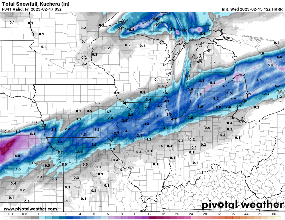
2/16/23 Winter Storm
in Lakes/Ohio Valley
Posted