
.jpeg.ee54af147b498e279581e1a7251c11d3.jpeg)
Baum
-
Posts
4,018 -
Joined
-
Last visited
Content Type
Profiles
Blogs
Forums
American Weather
Media Demo
Store
Gallery
Posts posted by Baum
-
-
IZZI itchin to throw up the watch:
COMING
OUT OF THE BRUTAL COLD SPELL MEANS THAT PAVEMENT TEMPS WILL BE
WELL BELOW FREEZING AND AIR TEMPS DURING THE SNOW SHOULD BE IN THE
TEENS, SO SNOW WILL ACCUMULATE IMMEDIATELY ON PAVEMENT AND LIKELY
RESULT IN HAZARDOUS TRAVEL CONDITIONS. SOME OF THE HIGHEST TRAVEL
IMPACT EVENTS EACH WINTER ARE SUB-ADVISORY AND OFTEN LESS THAN 1
INCH SNOWFALLS WITH VERY COLD TEMPS AND THIS SYSTEM DEFINITELY
HAS THAT LOOK TO IT.-
 2
2
-
 2
2
-
-
21 minutes ago, Hoosier said:
Will be interesting to see if people are a little gunshy if it trends better after what just happened. Can't really compare this setup to the current one though.
I'd issue a watch with this afternoons package to be on the safe side. All kidding aside, given the wind and cold with this event you can see why the early watches were issued. If we had a foot with this thing...good luck.
-
1
-
2
-
-
blowing dirt
-
1
-
8
-
-
55 minutes ago, A-L-E-K said:
D5 call looking $$$
may get there a little different than planned.
-
3 minutes ago, Chicago Storm said:

The Euro is solely responsible for many NWS offices wearing a bag over their head tonight.
-
1
-
-
48 minutes ago, Malacka11 said:
I was/am in the acceptance phase, but whenever the radar starts lighting up I get carried away anyway. I'm just glad that it won't be raining on Christmas.
you're officially indoctrinated.
-
1
-
1
-
-
3 minutes ago, A-L-E-K said:
pre-xmas cad storm
brutal.
-
1 minute ago, Sciascia said:
This might be the most empty feeling Winter Storm Warning I can recall.
no question. Time to issue a Travelers Advisory.
-
I'm still riding my call from Monday
.jpeg.b8981bbef2fc70bfbfdd2ccae0e6cf21.jpeg)
-
1
-
-
7 hours ago, Baum said:
oddly, i still think this will be a memorable event and NWS offices will have been justified in the early lead time watches.
this argument was not helped overnight, i see. Good news is they can run with a WWA and most folks won't think much about it.
-
10 minutes ago, A-L-E-K said:
Call looking $$$
little did we know we'd count that as a win.

-
1
-
-
oddly, i still think this will be a memorable event and NWS offices will have been justified in the early lead time watches.
-
3
-
-
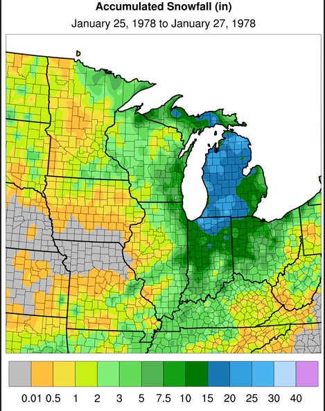
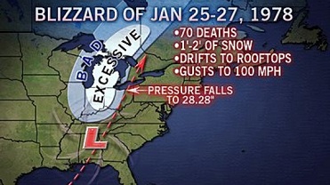
13 minutes ago, RogueWaves said:
We don't have the Fujiwara effects of '78 in this case, so if we can indeed keep this track nudged east across Lk Erie this could certainly treat SEMI better than that did.
To all the down-players of less SN total = storm cancel. Keep in mind that '78 did this in Mansfield OH on just 5-6" of new accums.
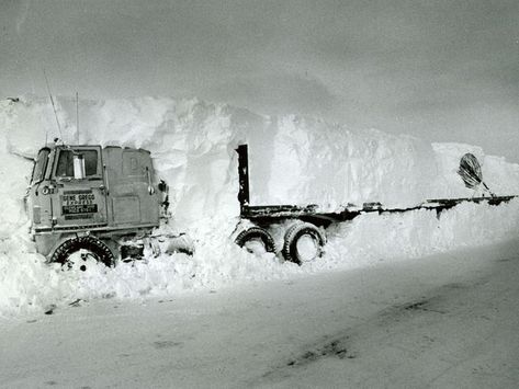
it would only be fitting to happen to Alek's rig in 5" of snow and a spot on call.
-
1
-
-
59 minutes ago, cyclone77 said:
Gonna reduce that original 4-6" call to 2-4".
actually ,not allowed.
-
1
-
-
2 minutes ago, SchaumburgStormer said:
I've seen worse snowfall maps for N IL today. Keep the trend going.
post of the day

-
1
-
-
reduced to looking for table scraps from the 18Z NAM
-
-
17 minutes ago, Chicago WX said:
GEFS tend to play follow the leader, but holy crap versus what was projected a day ago...to this below off the current 6z run.
And no not saying storm cancel at all, just posting the run.
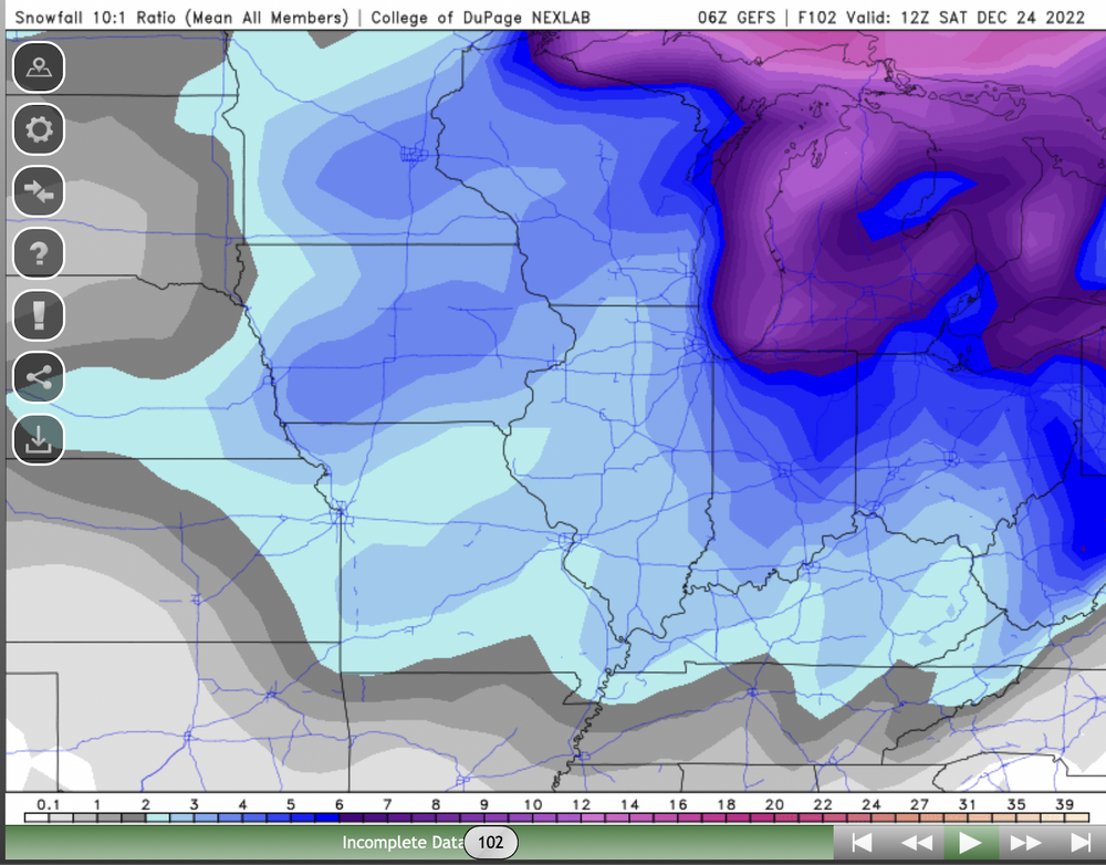
that's ugly.
-
LOT with another nice write up. If you get bummed with the back and forth of the model hugger crowd it provides a nice reality check when deciphering all the information used to hone in on a forecast with an event like this.
-
3
-
-
7 minutes ago, A-L-E-K said:
Gonna bust high

I tend to think you'll be spot on or bust badly low. Either way,
.jpeg.fc5e083104e44b8a6b212058a233348a.jpeg)
-
21 minutes ago, mimillman said:
18z euro will be less amped again.
Onset of precipitation keeps getting delayed a few hours each run as WAA snows shift well north out of the area. We are dealing with mostly a Thursday evening into Friday system now and yes, the scale may be large but we are at least 78 hours away from any meaningful precip. Still think a bit premature to hoist watches.
Of course it's a risk. But given the potential and the time of year you need to get the word out. It was a concerted effort to make the public aware. The normal tom,dick, and jenny isn't looking at the 18Z European model. Let's face it a widespread 2-5" event with below zero wind chills and 45mph winds the days before Christmas is a major hazard for joe public.
-
2
-
-
a taste of AFD's for shits and gigggles:
Minny:
IN SUMMARY, THIS IS SHAPING UP TO BE A HIGH END, LIFE-THREATENING
EVENT. THE RISK FOR BLIZZARD CONDITIONS HAS INCREASED ACROSS THE
ENTIRE REGION, EVENT THE EASTERN MINNESOTA AND WESTERN WISCONSIN
COUNTIES THAT ARE MORE WOODED. THIS, TOGETHER WITH THE EXTREMELY
COLD WIND CHILLS, NEEDS TO BE TAKEN SERIOUSLY.Beer Town:
CONFIDENCE CONTINUES TO INCREASE IN A POTENT WINTER STORM LATER
THIS WEEK THAT COULD BRING BLIZZARD CONDITIONS TO SOUTHERN
WISCONSIN.Des Moines:
TRAVEL ACROSS MUCH OF CENTRAL IOWA IS LIKELY TO BECOME
DANGEROUS IF NOT IMPOSSIBLE IN SOME LOCATIONS IN IOWA BY LATER
THURSDAY INTO FRIDAY. IN ADDITION, ANYONE STRANDED WILL BE FACED
WITH LIFE THREATENING CONDITIONS IF CAUGHT OUTDOORS GIVEN THE
EXTREMELY COLD WIND CHILLS, POOR VISIBILITIES AND DRIFTING SNOWPACK.
ACCORDINGLY, THE WINTER STORM WATCH HAS BEEN UPDATED WITH BLIZZARD
WORDING.Kansas City:
TRAVEL THURSDAY AND FRIDAY STRONGLY DISCOURAGED WITH POTENTIAL
WHITE-OUT/BLIZZARD CONDITIONSFort Wayne:
HOW QUICKLY THIS DEEPENING AND EVENTUAL WARM OCCLUSION OCCURS IS
THE KEY TO THE ALL IMPORTANT SFC LOW TRACK AND WHO ENDS UP TAKING A
DIRECT HIT FROM A CRIPPLING BLIZZARD. EVEN AREAS THAT DON'T TAKE A
DIRECT HIT, WHICH COULD INCLUDE A LOT OF THE IWX CWA, WILL STILL
SEE SUBSTANTIAL IMPACTS TO BE DISCUSSED SOON.Merry Christmas.
-
5
-
 2
2
-
-
3 minutes ago, Chicago Storm said:
Well, he went all out. I personally wouldn't have gone there...
yup. Went full IZZI on a day 4 forecast. Now we know who to blame
-
22 minutes ago, mimillman said:
LOT just pulled the trigger
8 minutes ago, SchaumburgStormer said:Then ends up way west going straight up lake michigan. NAM gonna NAM
maybe they saw the 18Z NAM
Winter 2022/23 Medium/Long Range Discussion
in Lakes/Ohio Valley
Posted
another mid month flip incoming...