PhiEaglesfan712
-
Posts
1,720 -
Joined
-
Last visited
Content Type
Profiles
Blogs
Forums
American Weather
Media Demo
Store
Gallery
Everything posted by PhiEaglesfan712
-
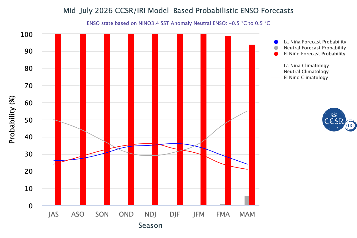
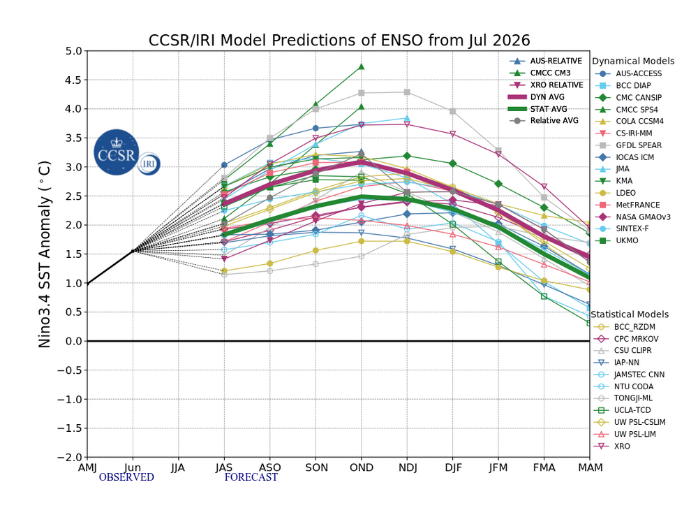
2026-2027 Super El Nino
PhiEaglesfan712 replied to Stormchaserchuck1's topic in Weather Forecasting and Discussion
Yes, I'm pretty sure the August spike was 2023, and likely the September spike as well. I remember there being an anomolous heatwave in South America in August 2023, and another one the following month. -
2026-2027 Super El Nino
PhiEaglesfan712 replied to Stormchaserchuck1's topic in Weather Forecasting and Discussion

-
Last year was a frontloaded warm summer, with the heat wave in late June and the warmth lasting all through July. The summer pretty much ended after July 31.
-
Probably not. I think we've already seen the worst of the heat. Unlike those years, we've had heat early and often, with 80s as early as March, 90s as early as April, and 100+ earlier this month. I highly doubt we see more 90-degree days in August than in June or July.
-
2026-2027 Super El Nino
PhiEaglesfan712 replied to Stormchaserchuck1's topic in Weather Forecasting and Discussion
94-95 was really skewed by February. The rest of that winter (November-January and March) absolutely torched in the Eastern US and was actually cool in the West. I'd say 14-15 was the best match for 25-26. -
2026-2027 Super El Nino
PhiEaglesfan712 replied to Stormchaserchuck1's topic in Weather Forecasting and Discussion
Makes sense. For about 50 years (before 2015-16), many of the strongest el ninos were followed by the strongest la ninas: 1972-73 super el nino -> 1973-76 la nina (with 1973-74 and 1975-76 being strong la ninas) 1982-83 super el nino -> 1983-85 la nina 1986-88 strong el nino -> 1988-89 strong la nina 1997-98 super el nino -> 1998-2001 la nina (with 1998-2000 being a strong la nina) 2009-10 strong el nino -> 2010-12 la nina (with 2010-11 being a strong la nina) -
2026-2027 Super El Nino
PhiEaglesfan712 replied to Stormchaserchuck1's topic in Weather Forecasting and Discussion
This was a textbook frontloaded warm/backloaded cold winter. If we continued this into spring, I believe April 1983 was the coldest April on record CONUS. That one had a major freeze/snow event in the Eastern half of the country (impacting the midwest on the 13th-16th, and North Carolina northward on the 19th-22nd). -
E PA/NJ/DE Summer 2026 Obs/Discussion
PhiEaglesfan712 replied to PhiEaglesfan712's topic in Philadelphia Region
I'd stay away from lettuce, at least until the drought is over. -
2026-2027 Super El Nino
PhiEaglesfan712 replied to Stormchaserchuck1's topic in Weather Forecasting and Discussion
Do you have the September or October 2015 prediction for JFM 2016? That JFM 2014 prediction was spot on, lol. -
E PA/NJ/DE Summer 2026 Obs/Discussion
PhiEaglesfan712 replied to PhiEaglesfan712's topic in Philadelphia Region
Perfect weather for Eagles football -
I thought we had one in late June 2012, just ahead of the early July 2012 heatwave.
-
2026-2027 Super El Nino
PhiEaglesfan712 replied to Stormchaserchuck1's topic in Weather Forecasting and Discussion
I feel like if the PDO doesn't reverse, especially with how big of an el nino we are expected to have, we are pretty much in a permanent -PDO. We haven't had a +PDO winter now since 2015-16, which was more than a decade ago, and is unprecedented. Even in previous predominant -PDO periods, we got a +PDO in there somewhere. Also, if we don't reach 175 ACE this year, it would be sixth straight year that we don't reach the threshold. Here is a list of longest periods with no hyperactive (175+ ACE) seasons: 1. 1962-1994 (33 seasons) 2. 1894-1925 (32 seasons) 3. 1934-1949 (16 seasons) 4. 2006-2016 (11 seasons) 5. 1927-1932 (6 seasons) [2026 would tie this streak, which began in 2021] The thirteen hyperactive (175+ ACE) seasons are: 1893 1926 1933 1950 1955 1961 1995 1998 2003 2004 2005 2017 2020 -
2026-2027 Super El Nino
PhiEaglesfan712 replied to Stormchaserchuck1's topic in Weather Forecasting and Discussion
As I said, I'm going to wait until the fall before taking this seriously. If the strong winter signal is still there in September/October, then you know it's going to be a cold and snowy winter. 2009-10 was the last time a strong winter signal held in the fall during a developing strong el nino. Contrast that to 2015-16 and 2023-24, when there was no strong winter signal in the fall months. -
2026-2027 Super El Nino
PhiEaglesfan712 replied to Stormchaserchuck1's topic in Weather Forecasting and Discussion
It depends on how early the el nino dissipates. If it peaks earlier than normal (in the fall, rather than winter), then we might get a robust la nina that challenges 1973-74 and 1988-89 (both of these, of course, followed robust el ninos). -
2026-2027 Super El Nino
PhiEaglesfan712 replied to Stormchaserchuck1's topic in Weather Forecasting and Discussion
Very low, less than 0.001%. Our strongest el ninos (namely 1982-83, 1997-98, and 2015-16) ended up between 2.5-3C. 5C is way off the charts. -
2026-2027 Super El Nino
PhiEaglesfan712 replied to Stormchaserchuck1's topic in Weather Forecasting and Discussion
All I know is that if we get a 5.0 and the PDO stays negative, then we're likely in a permanent -PDO. -
I'm surprised 2015 didn't hold the record. It rained heavy in the morning and later in the day.
-
Last summer was as frontloaded as you can get temperaturewise. The highest temperature was reached in June, and the summer was pretty much over on July 31.
-
2026-2027 Super El Nino
PhiEaglesfan712 replied to Stormchaserchuck1's topic in Weather Forecasting and Discussion
An interesting trend with the QBO this decade, with it wildly swinging back and forth from +QBO to -QBO each year): 2020-21: +QBO (11.15) 2021-22: -QBO (-26.34) 2022-23: +QBO (12.89) 2023-24: -QBO (-25.86) 2024-25: +QBO (13.78) 2025-26: -QBO (-26.92) 2026-27: +QBO? (2027-28: -QBO?) (2028-29: +QBO?) -
2026-2027 Super El Nino
PhiEaglesfan712 replied to Stormchaserchuck1's topic in Weather Forecasting and Discussion
1982-83 was a classical backloaded winter in the mid-Atlantic. In addition to the February blizzard, there was a snow/freeze event on April 19-20. Places as far south as North Carolina got a hard freeze. -
Do you know what is causing the wild temperature swings this spring and summer? This is like the 5th month in a row, dating back to March, where we have set a new temperature swing record.
-
E PA/NJ/DE Summer 2026 Obs/Discussion
PhiEaglesfan712 replied to PhiEaglesfan712's topic in Philadelphia Region
The last 3 days were perfect Eagles weather. 103, 102, and 101 degrees. -
2026-2027 Super El Nino
PhiEaglesfan712 replied to Stormchaserchuck1's topic in Weather Forecasting and Discussion
If the Eastern US is going to be cold in a strong/super el nino, I feel like the record warmth will have to be centered around the PNW or southwestern Canada. (2009-10's record warmth was centered around southwestern Canada, which had an effect on the 2010 Winter Olympics.) The fact that there is a warm signal in southwest Canada is promising. -
E PA/NJ/DE Summer 2026 Obs/Discussion
PhiEaglesfan712 replied to PhiEaglesfan712's topic in Philadelphia Region
PHL at 101 at 4 pm. This is the first time PHL has ever reached 101 on 3 consecutive days. -
2026-2027 Super El Nino
PhiEaglesfan712 replied to Stormchaserchuck1's topic in Weather Forecasting and Discussion
June 2026 PDO: -1.75 AMJ 2026 ONI: 1.0 AMJ 2026 RONI: 0.5