

JenkinsJinkies
-
Posts
1,612 -
Joined
-
Last visited
Content Type
Profiles
Blogs
Forums
American Weather
Media Demo
Store
Gallery
Everything posted by JenkinsJinkies
-
 Also I would not be shocked if the post PD warmup gets muted like all the other ones have since New Year's.
 -
It's looking to be short lived, followed by another cooldown that goes into March.
-
It’ll be sometime in March before we finally get a sustained warmup at this rate. Maybe even April.
-

-
Oh look, Hagerstown doesn't get screwed.
-
I said a month ago about how it can torch all it wants in April. Well if the metros can get enough snow this month to surpass climo then I can accept a March torch. It’ll have earned it in that scenario.
-
After RevWar's little fit I don't want to hear any more complaints about me.
-
I’m also not buying the post PD warmup.
-
WxUSAF's weak ass frontal passage thing.
JenkinsJinkies replied to dailylurker's topic in Mid Atlantic
Usually that happens when the Niña breaks. Though last year it injected steroids instead. -
I was also not intending for my post to deny any relaxation, it’s just that some of the dates in the latter part of the range are showing up on google’s extended forecast and at the moment look rather mild. If the euro verifies then I think the highs will get walked back a bit.
-
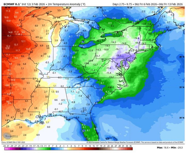
If the ridge bridge still looks like it’ll only last 3 days then the 11-16th map could pretty much cover the relaxation in its entirety. Which if so shows barely any deviation from the seasonal mean at that time.
-
I know that, you’re misinterpreting the post. This shows that the euro thinks that the warmup will be muted like all the other ones this season. The map Ji posted shows us barely deviating from average temps in that period, some areas on the bay even being slightly below average.
-
If the relaxation isn’t enough to cancel out this weekend’s cold is it really that much of a warmup?
-
Euro says “what warmup?”
-
Maybe wait a few days given the rug pull track record?
-
1. It's the GFS 2. You don't want to be in the bullseye this far out.
-
That top map is wind chill.
-
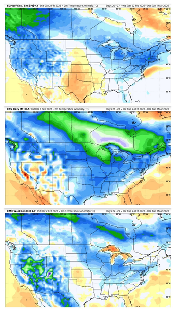
Found this in the SE board. Late month is looking BN again, not vodka cold but still below average. GFS is more intense, Canadian is more moderate, and Euro meets in the middle.
-
*looks at the title* We're so lucky there aren't any middle schoolers here.
-
Well how do we know that won’t end up like those mega torches perpetually two weeks away that some ensembles were showing a month ago?
-
Warmer as in closer to average after exiting the arctic or warmer as in our first 60 since December?
-
Yeah, isn't it only supposed to be there for about 3 days?
-
Based on what others have said there’s going to be a ridge bridge that should warm us up. For all of three days, and it could be a “warm up” that takes us from arctic to slightly above seasonal.
-
23-24 could count too due to the spectacular failure of the epic blocking.
-
Save is relative. It can mean anything from saving us from falling short of climo to saving us from making the futility list.


