

Powerball
-
Posts
14,286 -
Joined
-
Last visited
Content Type
Profiles
Blogs
Forums
American Weather
Media Demo
Store
Gallery
Posts posted by Powerball
-
-
42 minutes ago, Hoosier said:
From the "that'll work" department
MAZ007-015-016-019-022-023-290930-
/O.CON.KBOX.BZ.W.0001.220129T0500Z-220130T1000Z/
Eastern Essex MA-Suffolk MA-Eastern Norfolk MA-
Eastern Plymouth MA-Barnstable MA-Dukes MA-
Including the cities of Gloucester, Boston, Quincy, Plymouth,
Chatham, Falmouth, Provincetown, and Vineyard Haven
322 PM EST Fri Jan 28 2022

...BLIZZARD WARNING REMAINS IN EFFECT FROM MIDNIGHT TONIGHT TO
5 AM EST SUNDAY...

* WHAT...Blizzard conditions expected. Total snow accumulations of
  18 to 24 inches with localized 30 inches possible. Winds
  gusting as high as 70 mph.

* WHERE...Portions of eastern, northeastern and southeastern
  Massachusetts.

* WHEN...From midnight tonight to 5 AM EST Sunday.

* IMPACTS...Travel could be extremely difficult to impossible.
  Very strong winds could cause extensive tree damage.

* ADDITIONAL DETAILS...Considerable blowing and drifting snow
  along with near white out conditions at times. Snowfall rates of
  2 to 4 inches per hour is possible at times.

PRECAUTIONARY/PREPAREDNESS ACTIONS...

Travel should be restricted to emergencies only. If you must
travel, have a winter survival kit with you. If you get stranded,
stay with your vehicle.
Boston gonna Boston.
-
Several weeks ago, @Stevo6899 did predict that Chicago might end with 10" more for for the season than Detroit, when all said & done.
This storm, as currently depicted on the models, would definitely be the one to test that prediction.
-
 1
1
-
 1
1
-
-
We're going to be having power grid issues and another deep/prolonged freeze again here, so yeah, you guys will definitely get buried like you did last February.
-
 1
1
-
-
17 hours ago, Harry said:
A open gom can usually get the job done in situations like this.
Who is this stranger that is posting?
")
-
4
-
-
*IF* (big if) DFW manages to avoid seeing mesurable precipitation with the 1/31 system, this would tie for the 2nd driest January on record.
-
1
-
-
And of course, now the models are showing a system on the last day of the month that might just ruin our top 10 (let alone top 5) driest January on record...

-
A top 10 driest January on record seems to be a lock for DFW. Could even be a top 5 driest if tomorrow's system and the system on the 27th fails to produce measurable precipitation.
Will likely see an expansion of the extreme drought conditions for Thursday's drought monitor.
-
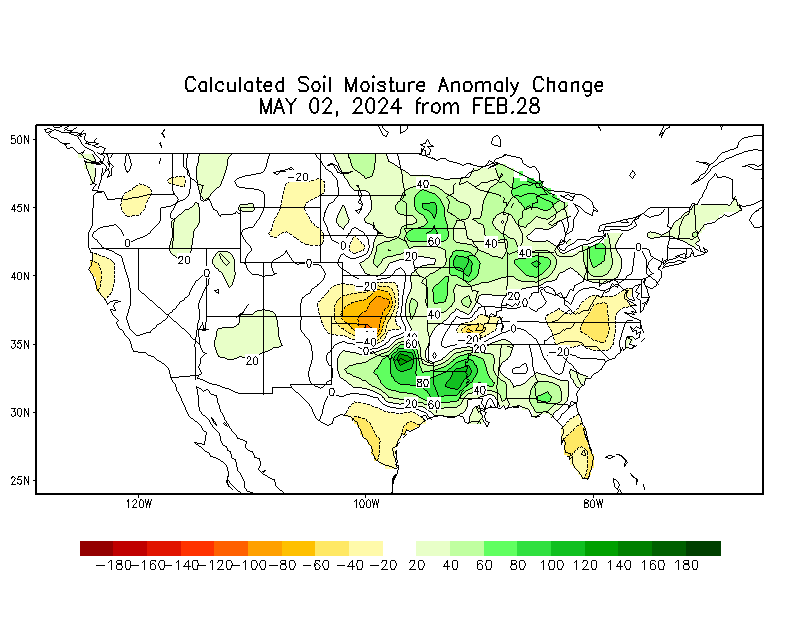
Brtual...

And the Soil Moisture's really drying up too:
-
1 hour ago, hawkeye_wx said:

Pretty crazy that we're halfway through Met Winter and Nashville has seen more snow than Chicago.
-
-
-
My kind of snowstorm.
Jealous...
000
FXUS61 KBUF 170550
AFDBUF

Area Forecast Discussion
National Weather Service Buffalo NY
1250 AM EST Mon Jan 17 2022

.NEAR TERM /THROUGH TODAY/...
...MAJOR WINTER STORM TONIGHT THROUGH MONDAY...

Regional radars showing an intense band of snow moving north across
Western NY, with confirmed snowfall rates of 3-4"/hr and
extremely large dendrite conglomorates. A few spotter reports
and webcam imagery show sleet mixing in close to Lake Erie, a
result of strong downsloping off the higher terrain of NW PA and
the Southern Tier. This mix with sleet won`t last too long, but
may briefly spread into other areas in Western and Central NY
overnight. We expect the heaviest snowfall rates of 2-4"/hr to
fall between now and 6am, then snowfall rates will back off to a
more manageable 1-2" per hour.
-
23 hours ago, mimillman said:
I wanna know how this is gonna happen
La Nino.
-
23 hours ago, luckyweather said:
Unpopular wish - Tonga volcano keeps emitting and creates a year without a summer and it snows in June.

-
17 minutes ago, StormChaser4Life said:
This has to be the lamest snow "event" I experienced in a long time. Pixie dust. Wet a** pixie dust. Not sticking. Temps right at 32. Snow has barely made it east of me and you can tell it's fighting dry ne flow. I will be shocked if we get a inch. Make winter storms great again. This sucks. Lol
I'd give this rant a C- at best.
You can learn a thing or two from beavis.
")
-
1
-
 2
2
-
-
Pretty dire 00z GFS run last night. Most of OK and TX sees virtually no measurable preciptation the entire run.
-
2 hours ago, StormChaser4Life said:
Obviously long range HRRR not reliable but find it interesting it has the sfc low and snow shield significantly farther east than global models. Definitely something to keep an eye on.
Probably typical long range HRRR being overamped type of deal.
-
1
-
1
-
-
What a weirdo system.
If it keeps trending SW, even we might get snow from it.
-
22 hours ago, nwohweather said:
My complaint is everyone expects a Traverse City winter. The last 15 years have totally spoiled snow fans with its deep cold and deeper snows
-
19 hours ago, ILSNOW said:
Rant!!!
I remember a time when we would have a parade of clippers ( what happened to them) and when storms would phase and bring big storms (what happened to them). Outside of last weeks snow we have had nothing even to track and the next 10days to 2 weeks don’t offer much hope. It’s going to be almost the end of January and we will have snow one day this winter. Places in Kentucky and Tennessee will have twice as much snow!!!!
They became extinct for everywhere not named Boston or Minneapolis after GHD 1.
-
On 1/5/2022 at 12:35 PM, Spartman said:
That's actually the 00z GFS map. Here's today's real 12z GFS map.

A winter to remember for the Music City!
-
1 hour ago, CheeselandSkies said:
Wouldn't that be Mayim, now?
Sent from my Pixel 4a using Tapatalk
That would be Ken and Mayim now.
-
1
-
-
9 hours ago, fluoronium said:
I'm glad I saved a copy of this gem. We can't let the SPC cover up this one

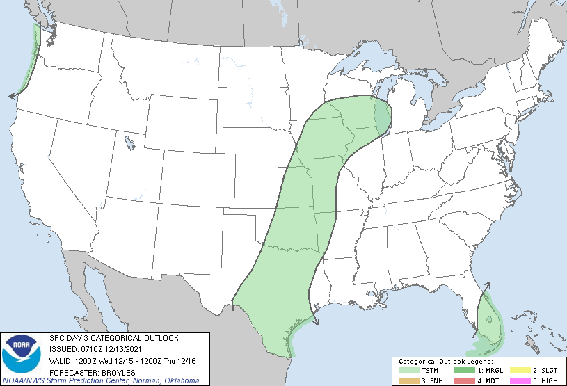
And of course, it had to be a Broyles outlook.
Peak Clown Shit there...
-
1
-
-
7 hours ago, TexMexWx said:
Strangely enough, almost unwittingly drove past a small grass fire this afternoon (east Plano). First time I've seen one personally. The grass was definitely very dry, but no clue how it started- the median in the middle of the road was just covered in flames. Definitely hadn't been going on for long, but it looked like it was fixing to jump across the road, but again I have no real experience with fires (this road was between a church and a high school right as students were leaving, so it was busy). As soon as I grabbed my phone to dial 911, a firetruck rounded the bend into my FOV and took care of it.
I guess that's just a little experience I wanted to share to which the severe drought here is relevant.
We'll see what happens the rest of this winter / early Spring, but it's certainly something you don't want to see headed into the warm season, because of the positive feedback loop with temperatures.
-
1
-

Feb 1 -3 GHD III
in Lakes/Ohio Valley
Posted
I would legit be jealous if that happened.