

Powerball
-
Posts
14,286 -
Joined
-
Last visited
Content Type
Profiles
Blogs
Forums
American Weather
Media Demo
Store
Gallery
Posts posted by Powerball
-
-
3 minutes ago, Kaner88 said:
Never a good sign when the 18z RGEM is your best friend
It did get GHD 1 right. So anything's possible, lol.
-
2 minutes ago, michsnowfreak said:
The Southern row of counties in Michigan is golden right now.
I think he meant in terms of the epic amounts. Those might end up south of the border.
But in terms of getting a decent storm, then yeah, that seems to be guaranteed for Southern MI.
-
Just now, Jonger said:
Congrats corn country on your storm. Southern Michigan is just about out of the mix.
You're getting snow for sure.
Just may not be as much as you would like.
-
3 minutes ago, ILSNOW said:
right about now Chicago storm will say 18z NAM has bumped south
You mean there was a change in orientation.
")
-
 1
1
-
-
12 minutes ago, Baum said:
really? I was going to post it feels like spring outside today, and if that warm weather meant the storm would be further north. Also, with the snowpack melting off a bit that should help as well to bring it north. I have no pride when it comes to landing a 20" snowstorm IMBY.
I'm just waiting for the "nowcasting time!" posts.
-
 2
2
-
-
16 minutes ago, CANNOTDIVIDEBY0 said:
I saw someone say something about the high pressure over Canada is running a bit weaker than what is modeled. Looks like its about 2-3mbr weaker with my completely untrained eye. Will this have any real impact on the trajectory of the main event?
*I guess I should mention that the pressure right now is a little bit weaker. I don't know what it was 6~hours ago.*No.
The evolution of the upper level trough and jet dynamics is what will dictate the strength of this storm and the location of the best forcing.
-
2
-
-
The 12z EURO is also slightly drier.
I will make a final call after the 00z run, but the 10-15" prediction I made earlier (with isolated higher amounts) doesn't look too bad
-
3 minutes ago, Powerball said:
If there's any solace, there was at least GHD 2 that did the opposite. It had started to trend south at this point on the models, then it corrected back north at the last minute, which ended up being correct.
Granted, it was a different setup and not exacly a Jan '67-esque big dog, but my point is I wouldn't completely rule anything out just yet, especially with a +NAO and the jet dynamics at play. It's not like you need this to shift all the way NW from KY/PA, but just a 50-mile shift.
Jan 2014 also started to shift SE before correcting NW at the last minute.
-
1
-
-
9 minutes ago, Harry said:
Not a freakout. I have just seen this one too many times to know better. Again see Dec 04, VD 07, March 08, etc, etc.
Am I disappointed? Sure. Had figured we were past this kind of model mayham ( especially with the GFS ) to be proven wrong which is irritating in itself. For whatever reason storms of this magnitude keep finding ways to avoid here which yes is disappointing. Nearly everyone in this sub has seen a historic snowstorm total in their back yard in the past 18 years but here over to Detroit and it now looks to repeat it again and for some further south they are about to be visited again by a history making storm . I don't care who it is one has to be disappointed if you fall into the zone of keep getting missed by such storms except you perhaps. Lol Life goes on though.
Now for the euro which should be up and running!
If there's any solace, there was at least GHD 2 that did the opposite. It had started to trend south at this point on the models, then it corrected back north at the last minute, which ended up being correct.
Granted, it was a different setup and not exacly a Jan '67-esque big dog, but my point is I wouldn't completely rule anything out just yet, especially with a +NAO and the jet dynamics at play. It's not like you need this to shift all the way NW from KY/PA, but just a 50-mile shift.
-
1
-
-
What/who do we have to sacrifice in order to get the 1/29 12z GFS run back?
-
1
-
-
1 minute ago, Chicago Storm said:
12z GEFS mean
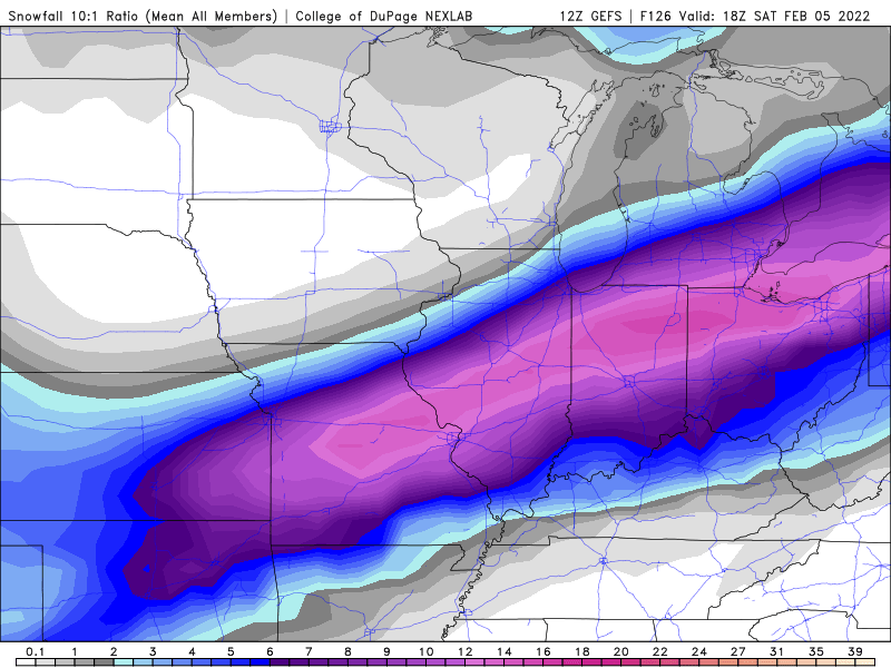
Another bump southward.
-
1 minute ago, KokomoWX said:
Thanks. I updated my original post.
Is "professional meteorology analyst" now the PC label for "weather weenie?"

-
1
-
1
-
-
7 minutes ago, Weather Mike said:
Agree GFS making some slight corrections south. Euro coming slightly north. ICON south. RGEM and NAM coming north.
What a battle. Some changes of 30-50 miles makes a difference.
My comment about the EURO was tongue in cheek.
In my honest opinion, we'll probably see further consolidation with the heaviest amounts from C. Illinois, N. Central IN and NW Ohio, along with a continued but slow drying trend.
-
3 minutes ago, Stevo6899 said:
Models really struggling with this setup. Gfs led the way being amped up, now its more on the southern end.
Now watch the EURO come in super amped.

-
1
-
-
Just now, nwohweather said:
Oh I am on Wednesday for sure. It'll take a second for the front to pass and the column to completely cool
I'm talking about after Wednesday's changeover occurs.
-
2 minutes ago, nwohweather said:
Obviously mixing will cut down some of these absurd numbers a bit, but still this is a pretty insane to see so close to the event. Just for context, Toledo averages 37" of snow a year & Findlay gets 25". This storm at a likely 3-6" Wednesday and 8-16" on Thursday could drop over half season's worth in 36 hours. Also lets not forget, the backside of this is going to drop air temps into potentially the negative double digits on Friday
I'm not convinced precip issues (at least of consequence) will make it as far NW as Toledo and Findlay.
They might get occasional sleet mixing in, but unless it's ongoing for an extended period, that doesn't do much to cut down on totals.
-
5 minutes ago, ILSNOW said:
and of course 12z RGEM comes north

No kidding. Almost looks like the GFS did before last night.
-
2 minutes ago, vwgrrc said:
Not sure if I'm looking at the same thing - but at least the 12KM NAM i'm looking at, Thursday 9-15z has DFW under mostly freezing ice and sleet. That's 6 hours under icing condition!
I'm looking at the Total Accumulated Freezing Rain QPF map on Pivotal Weather.
Do note, rain can technically fall with air temperatures below freezing but still not actually accumulate much because of residual warm air on surfaces.
-
8 minutes ago, DFWWeather said:
It is still ingesting data, and I bet those amounts go up a bit into tomorrow. It is forcasting and inch plus of sleet which is still Watch criteria. Remember a Watch can be upgraded or downgraded to a Warning or Advisory.
The headlines (or lack thereof) really don't matter to me.
I hate ice (along with the extreme cold coming behind it) and I'm not looking forward to any amount of it.
I'm hoping it does trend to a nothingburger.
-
21 minutes ago, dmc76 said:
Conveyor belt of snow per NAM for SEMI.
And the heavier rates were still ongoing at the end of the run, so it would have had more snow to come.
-
1
-
-
5 minutes ago, DFWWeather said:
Looks like 12z NAM has come aboard. Winter Storm Watch probably will get issued this afternoon.
If you look closely, the NAM spares the heart of the Metroplex from much (if any) ice, with only advisory criteria amounts in the outer suburbs.
(^^^Oh, Thank Heaven!!!)
Different story along the OK border around Sherman though.
-
1 hour ago, DFWWeather said:
The delay in the Winter Storm Watch is because of the NAM. This model is usually king in its handling of shallow/dense Arctic airmasses and it is delaying the arrival of the coldest air. It is the model that has thrown the monkey wrench into this forecast - lol! This has huge impacts on forecast amounts with the NAM showing hardly any accumulation. It also is keeping the storm track a bit further north. I must say this is pretty unusal. It also should be noted, the entire 0z suite of CMC ensembles have warmed from where they were, though the operational has not really. The ECMWF, ICON never get us below 20°F with this event, or just barely in the case of the ICON. The ECMW is also a bit delayed on the 32°F arrival of air into the Metroplex.
Given past experiences with 1050 mb Arctic highs, I don't see what would hold up cold air like that. I would side with the colder faster solutions.
The amounts forecasted above by the FWD NWS is in line with Winter Storm Watch criteria. I would have issued the Watch. It can always be canceled or downgraded to an Advisory (that is exactly what a Watch is for anyhow). If they were making a decision on a Warning, I would have held off.
I definitely think waiting for the 12z model cycle at least is the best move.
Those 00z/06z model runs might have been the start of a trend towards a relatively less signifucant event.
-
2 minutes ago, Baum said:
Chicago had never been modeled for such. And it still looks like in excess of 20" is on the table for those that catch both portions of the event.
Besides the band seemingly starting to consolidate south of GFS/NAM/SREF had it, the amounts have been slowly coming down too. So I wouldn't even say 20"+ totals are a lock.
-
4 minutes ago, Baum said:
To be honest at this point yesterday we were not even in the game per the GEM, EURO, and NAM. If you were anticipating a 2' snowstorm you were always going to be dissapointed. From what I can tell the GFS and Euro have sort of settled on a track that will split the metro. So your call of 4-8" looks reasonable and basically fits what LOT has out. Plenty of wildcards still in play track of main event, lake enhancement, exact placement of frontal band(which many times ends up different than modeled). Bottom line, it's a fun event to track and it sure seems like a good percentage of this forum will see a significant event over a 3 day period. So all is good. Enjoy the chase, as they say.
Still, it is unfortunate that we got several runs (that seemed to be consistent at first) with those insane amounts setting up further NW.
Now some people will be disappointed over getting what will still be a big snowstorm (just not epic/crippling/historic).
Feb 1-3rd GHD III Part 2
in Lakes/Ohio Valley
Posted
See bottom of page 15.