

Powerball
-
Posts
14,286 -
Joined
-
Last visited
Content Type
Profiles
Blogs
Forums
American Weather
Media Demo
Store
Gallery
Posts posted by Powerball
-
-
28 minutes ago, vwgrrc said:
Like a hotel room? How you know they will have power if you don't
Sent from my SM-G991U1 using Tapatalk
They had it last February.
There are some hotels (though not many) that have backup generators.
-
Just now, Powerball said:
FFS. The 06z runs are the worst yet for ice. Widespread 0.50"+ freezing rain across *ALL* THE Metroplex.
And that's not including the sleet on top of it.
What a ****ing disaster.
I did book a room though. I'm not getting caught without power like I did last time.
-
 1
1
-
-
FFS. The 06z runs are the worst yet for ice. Widespread 0.50"+ freezing rain across *ALL* THE Metroplex.
And that's not including the sleet on top of it.
What a ****ing disaster.
-
Just now, HillsdaleMIWeather said:
0Z GEM is a touch northwest
You mean it had a shift in orientation.
-
 3
3
-
-
Pretty decent bump south with the 2nd wave on the 00z GFS.
-
1
-
-
4 minutes ago, snowstormcanuck said:
That'd be something...rain with the overrunning and a whiff with the main storm. If this were 10 years ago I'd need a straightjacket and IV of valium.
But somehow, Toronto still makes out quite well with the storm on the 00z RGEM.
Yet, Cleveland gets a massive sleet fest.
-
1 minute ago, snowstormcanuck said:
That'd be something...rain with the overrunning and a whiff with the main storm. If this were 10 years ago I'd need a straightjacket and IV of valium.
I think Brian D's original title was more appropiate for this storm.
-
Just now, Powerball said:
It might be cutting due NNE into Ohio.
Maybe not, it hit a wall in Kentucky.
-
1 minute ago, Powerball said:
2nd wave relatively organized on the RGEM over
Memphis(60hr).EDIT: Meant Nashville.
It might be cutting due NNE into Ohio.
-
2nd wave relatively organized on the RGEM over
Memphis(60hr).EDIT: Meant Nashville.
-
Since someone asked earlier, here's the 00z HRW FV3 through 12z Thursday. It also shows that "lull" between waves like the NAM.

-
1
-
-
1 minute ago, Chicago Storm said:
The change this run did end up making for a more organized storm system a bit as it moved east through the sub-forum (IN/OH/MI).
Still a few bumps back the other direction before it would be really noteworthy.
There is certainly the remote possibility that enough spacing between the first and second wave could allow for that 2nd wave to cut to Cincinnati, which would bring back the solution we were seeing a couple days ago.
-
1
-
-
2 minutes ago, Chicago Storm said:
Looks to be more tied to the wave diving into the Pac NW, which eventually gets involved with the wave coming out of the SW.
Notice how earlier runs had that wave diving more southward into the West, before eventually trending further NW with less of a dive the past several runs. This in turn has lead the heights being shunted down ahead of the main ejecting trough.
This run seemed to reverse the Pac NW wave issues a bit, but the faster timing of the SW wave ended up still lowering heights.
It did try to finally cut towards the end there, but still too little too late for those on the northern edge.
-
It makes sense.
As the first wave trends beefier, it surpresses heights in its wake that forces the 2nd wave further south, along with the better forcing/moisture.
-
1
-
-
One trend that seems to be legit is that the models are getting beefier with the amounts from that first round. The 00z NAM continues that trend.
-
On 1/28/2022 at 8:45 AM, Powerball said:
*IF* (big if) DFW manages to avoid seeing mesurable precipitation with the 1/31 system, this would tie for the 2nd driest January on record.
It looks like DFW will be safe from precip between now and Midnight.
-
1
-
-
4 minutes ago, ILSNOW said:
Without a doubt the RAP and HRRR are on to something
Truer words never spoken, lol.
-
5 minutes ago, mimillman said:
So you’re sayin there’s a chance
-
1
-
3
-
-
Just now, michsnowfreak said:
That's only thru 72. Thru 84 looks even better.
Oh I'm sure, because there was still another 6 hours of snow to go.
-
7 minutes ago, ILSNOW said:
Enjoy
Seems like more the area of snow expanded on the edges, which made up for any shifts.
It's also a bit wetter.
-
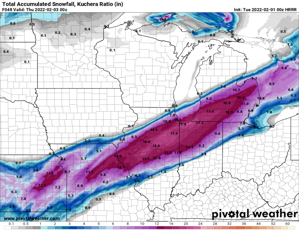
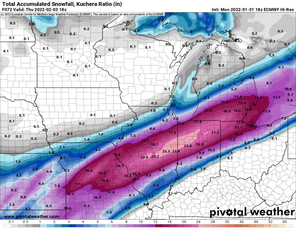
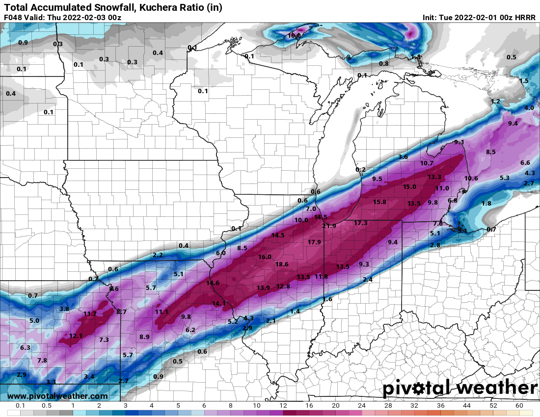
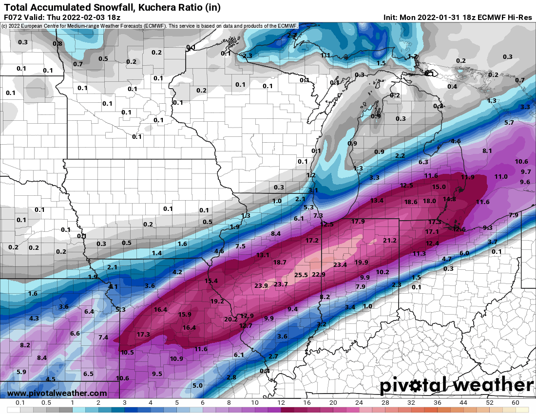
Can someone please post the 18z EURO map?
-
5 minutes ago, Air Traffic Control said:
This run gives me nightmare fuel. That's a LOT of sleet and ice, which, last time in this area during GHD I, kicked off power for two weeks.
Please go south, runs! If my 1" snow season total gets crushed by inches of ice and sleet, I'll be legit frozen solid in my generator-less house, jajaja...
Relax.
RAP is notorious for being way NW / too amped in its long range.
It's mostly being posted as weenie fodder for those on the northern edge.
-
2
-
 2
2
-
-
That 21z RAP would probably look like the 12z GFS run from 1/29, if extrapolated.
But alas, that is the ceiling.
-
Just now, Jonger said:
What's the verification rate on that model?
As I said earlier, the last time it got something right was GHD 1 right, haha!
But it's a northern outlier right now any way.
Feb 1-3rd GHD III Part 2
in Lakes/Ohio Valley
Posted
*ahem*, the proper term is "orientation"...")