

Powerball
-
Posts
14,286 -
Joined
-
Last visited
Content Type
Profiles
Blogs
Forums
American Weather
Media Demo
Store
Gallery
Posts posted by Powerball
-
-
Severe Thunderstorm Watch has been issued for North Texas (including DFW) until 10pm.
-
1 hour ago, michsnowfreak said:
Dry. Warm. Dry. Sunny. Dry. Colors continue to pick up steam despite the warmer weather. Did I mention dry?

I did hear the east side of the city got a surprise strong storm (with flash flooding) yesterday though, which is something.
Apparently, DET picked up nearly 2" of rain from it.
-
On 8/8/2025 at 6:05 PM, DFWWeather said:
I'd be curious to hear everyone's input on this, especially those that know what is going on with the weather models. For the last 5 to 8 years, I have been noticing a pronounced trend in the models high temp forecasts to be excessively too hot. This is particularly evident in the summer time high temps for DFW. The operational GFS is the worst, in fact so bad, I have to throw its numbers out beyond day 3 when forecasting. To be clear, I'm talking about the raw numbers of the model itself not the MOS numbers. The raw GFS numbers can be as much as 8 to 20 degrees hotter than what actually verifies. It consistently forecasts high temp values above 110°F, sometimes as high as 120°F plus. First off, the hottest temp ever recorded here is 113°F, and we have only been 110°F or warmer 14 times out of 125 years of records. So that is absurd! If I had to pick a model to forecast summertime temps for the DFW area, it seems the Canadian ensemble average is the closest to what actually verifies. The ECMWF was a close second until this summer. It has now skewed warmer. This summer all of the models tend to want to forecast temps into the 100s when there is no valid reason for that if one looks at the pattern and conditions. Our normal temp in the height of summer is 97°F. Current forecasts I have seen for DFW over the past several days have been 2 to 5 degrees too hot than what verifies. The NBM numbers are also being skewed too warm because of this. So what is happening?
The models get far too aggressive with the mixing out of moisture through the column.
In dry Summers such as 2022, 1980 and 2023, they're closer to right than wrong. But in years like this one, 2021 or 2015 where there aren't drought conditions ongoing, they tend to be way off.
-
DFW just recorded its 7th 100*F day of the season as of 3pm. Highs in the upper 90s are forecasted for tomorrow.
And looking into the medium/long range, after another bout of below-normal temps this weekend, there's still plenty of Summer (90s) to come yet...
-
Nelson didn't say anything that others weren't thinking to themselves.
-
 1
1
-
-
Seems Milwaukee (especially the south side) is really getting a shellacking.
-
We're even getting the smoke way down here.
It will make for a nice sunset, at least.
-
On 7/25/2025 at 7:17 PM, Powerball said:
DFW only topped out at 98*F yesterday and 99*F today, so the 100*F drought continues...
Looks like the top 10 list for latest 1st 100*F days may be in play now (starting with 8/7). Meanwhile, 1973 and 1906 are the only years in recorded history thus far that DFW didn't see a single 100*F day.
BTW, the high of 98*F yesterday is also amongst the latest in the season DFW has recorded a temp that high, with the exception of 2002.
DFW did finally hot 100*F for the first time this season yesterday.
Should log 2 more today and tomorrow.
-
DFW only topped out at 98*F yesterday and 99*F today, so the 100*F drought continues...
Looks like the top 10 list for latest 1st 100*F days may be in play now (starting with 8/7). Meanwhile, 1973 and 1906 are the only years in recorded history thus far that DFW didn't see a single 100*F day.
BTW, the high of 98*F yesterday is also amongst the latest in the season DFW has recorded a temp that high, with the exception of 2002.
-
28 minutes ago, michsnowfreak said:
Thought this was interesting. 90° days in the US are 23rd lowest on record to date.
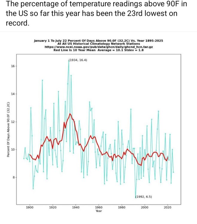
DFW still has yet to hit 100*F this year, although that may change today.
-
2 hours ago, TheClimateChanger said:
High temperatures yesterday across Southeast Lower Michigan. Reported highs ranged from 92 at Port Hope, Port Austin, Cass City and Linden, to 102F at Grosse Pointe Farms. The latter looks a little high, but I'm not sure of the microclimate there. The next closest (not shown) was 98F at Selfridge ANG Base. That site is on xMacis, but for some reason, the data doesn't get input until the end of the month. In fact, there are records for Mt. Clemens Area extending back to the 1800s.
Weather Bureau sites, plus Uni. of Mich. (5 pm observation time) and White Lake 4 E (midnight to midnight - NWS office site):

Other co-op sites, with morning observation times. Note that these go into the book as the temperatures for 7/25, but the highs occurred yesterday and the reported lows this morning:

I wonder if that observer in Grosse Pointe is the same one that perpetually lowballs their snowfall totals...

-
2 hours ago, TheNiño said:
Slight risk added for Chicago metro today? Didn’t really see that one coming.
Got strong surface heating, modest mid-level lapse rates and surface dews in the low/mid 70s. So wet microburst potential is definitely on the higher end today.
-
2
-
-
DFW has another shot (albeit marginal) the next 2 days at 100*F.
But at this point, if it doesn't happen, I'm all aboard the futility train...
-
51 minutes ago, Torchageddon said:
The impossible happened: on what was suppose to be a mostly clear sunny hot day, I woke up at 7 to see dark overcast!!
 For 9th in a row that comes to 0.00052% - this is incomprehensible. Now the caveat is what range in the morning to use as this morning isn't quite so long for darkness. At 815 there were bluer skies coming in a bit to the west but the sun was mostly covered and new clouds generated over me as of 850am. I've used up to this point 6am-10am but the majority of these Thurs mornings have been overcast til noon at least. I could increase my % to 35-40% to reflect less time in the dark but that muddles this.
I checked my own records for mornings even before May 22, which fortuitously I keep track of. May 15th was partly cloudy, but the previous 3 Thur mornings were all dark overcast!!
 The last clear Thurs morning I had was all the way back on April 17!!! Only 1 out of the last 13 had partly cloudy with sun, WTF!? As you go back into mid-spring the chances of an overcast morning skyrocket but nearly 13 in a row, come on....
Them are the doldrums of living in the Great Lakes region (specifically downwind).
I feel for you...
-
 1
1
-
-
Seems DFW may have its first legit shot at seeing its first 100*F day tomorrow, per the latest NWS grids.
But if it doesn't happen tomorrow, the "lack-of" streak continues for the forseeable future.
-
10 hours ago, nvck said:
unbelievable 14"+ of rain in 24 hours in central texas, with some areas seeing 19" over 3days
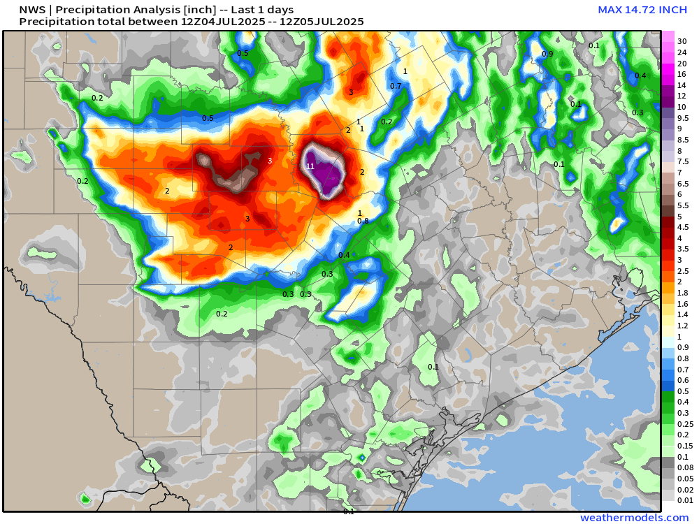
A couple things.
1. This specific area has desperately needed rain as they've been dealing with a multi-year severe drought since at least 2022. It's just unfortunate that it came in the form of a historic flash food event.
2. There have been 56 confirmed deaths so far, and there's still 27 people missing. This is in part because the worst of the flooding occurred in the middle of the night.
-
 1
1
-
-
10 hours ago, michsnowfreak said:
My aunts sister has lived in Texas since the late 1970s and HATES the summers down there. She always says that no one goes out during the day.
Obviously you can adapt to an extent to long winters or summers, but people will always have preferences.
The bolded is a huge exaggeration, lol. But Texas summers are like Michigan winters in that a lot of people are staying under the A/C or heat as much as they can.
-
On 6/24/2025 at 6:03 PM, Stevo6899 said:
They say the same when they have those rare days in the 40s. Thats us for atleast 5 months. All depends on individuals tolerance. I think most people would take warmth over arctic air.
I started to post exactly that in response, but yeah. You're spot on, lol...
EDIT: Funny thing is, after 3 top 20 hottest Summers in a row before 2025, this Summer's looking to be more on the normal (if not cooler) side with no real heatwaves on the horizon for us. We still have yet to see our first 100*F+ day and should close out June without one.
-
 1
1
-
1
-
-
43 minutes ago, sbnwx85 said:
IWX kind of on an island issuing an Extreme Heat Warning but with the overnight lows being so incredibly warm, I think it’s the right call.
To be fair, the bigger metros with UHI effect (Chicago, Detroit, St. Louis, Milwaukee, Pittsburgh, etc.) are also under Excessive Heat Warnings.
-
1
-
-
-
2 minutes ago, canderson said:
It does look that way - how is the wind though?
At least in Collin / Denron Counties, there were numerous 60-70 MPH wind gusts, which any other day if not for all the hype would be a solid severe weather event.
It is rapidly turning into a Flash Flood situation for DFW now.
-
1
-
-
Scenario #2 from FWD's AFD ended up panning out.
-
Just got the notification for a Destructive Wind Warning (80 MPH) here.
-
13 minutes ago, canderson said:
True, that cell near McKinney especially. But it’s very sporadic.
And the supercell down around Stephenville. It's producing massive anvil/outflow blowoff.

October 2025 General Discussion
in Lakes/Ohio Valley
Posted
I think multiple things can be true.
Yes, people might be ready for fall, but I highly doubt they were complaining about having a bunch of warm and sunny days in the mean time.
EDIT: Now if it were truly hot/humid weather, then maybe a different story.