

Powerball
-
Posts
13,763 -
Joined
-
Last visited
Content Type
Profiles
Blogs
Forums
American Weather
Media Demo
Store
Gallery
Posts posted by Powerball
-
-
North Texas (including DFW) is looking a lot better on the lateat model runs skycover-wise. HRRR is even picking up on the temp drop during totality.
Hopefully, this trends continues and holds.
-
 1
1
-
-
If you had told me Maine would have Texas beat for sky cover with this Eclipse several months or even several weeks ago, I would have called you crazy.
And yet, here we are...
-
1 hour ago, cheese007 said:
Looking more and more like Monday in TX will be more noteable for severe potential than eclipse visibility


Fortunately, as things stand now, the severe weather potential should hold off until the late afternoon / early evening hours (after the Eclipse time).
-
2 hours ago, CheeselandSkies said:
Neither of our major national news partners at work (NBC News, and CNN) have ANY affiliate content available for the 50th anniversary of the Super Outbreak. Zilch. Nada.
Another sad reminder that there are severe weather geeks, and then there's everybody else.It's an election year. All other news goes on the back burner.
-
Seeing more (recent) reports of TSSN+ from Green Bay on Twitter.
EDIT: As well as more lightning strikes on the tracker.
-
-
Lightning is being detected up near Green Bay.
-
41 minutes ago, Floydbuster said:
3 hours later, since that sounding, the atmosphere in SW Ohio has seen significant recovery, primarily thanks to the 40-50kt LLJ.
With the impressive shear & forcing in place, you don't need a ton of instability nor that much of a temperature spread for tornadic weather.
-
Radar trends are looking pretty ominous for the Cincinnati area.
-
Still a pretty brutal cap on the 20z FWD cap.
We'll see if the storms can prevail through it post-peak heating
-
Much of Central OK and some of the Texas counties along the Red River have been upgraded to a Moderate Risk, again mainly for hail (45% hatched).
-
The latest SPC Day 1 Outlook has expanded the enhanced risk area to include all of North Texas (includiing DFW), mainly for hail.
-
39 minutes ago, Chargers09 said:
Way too early
The precise weather conditions at the exact time of the eclipse for any specific location remain unknown this far out, but we're now close enough to April 8th to discuss large scale pattern trends as well as ensemble data, which is what FWD has been doing for the past several AFDs.
-
1 hour ago, michsnowfreak said:
It doesnt matter if its cold or warm or anything in between. Its all about skycover that day.
Yup!
-
28 minutes ago, TheClimateChanger said:
Let's hope this is wrong.

Indeed.
-
 1
1
-
-
Doubtful...
-
10 hours ago, michsnowfreak said:
My sister has lived in Saint Clair Shores for 10 years now and the number of times we get more snow than her far outnumbers times we get less (don't think I don't ask for updates in our group text every single snowfall
 ). But yesterday they got nailed. Seemed quite high ratio too. When I was out with my nephews, the snow in the shaded areas remained fluffy while in the sun it was great packing and rapidly melting.
I can confirm second hand.
My mom said there was enough snow for her neighbor to pull out the snow blower.
She was tiffed too because she was telling me Kim Adams swore much of the snow would fall north of the city the night before (and in all fairness, that's what the models indicated as well). She about blew a gasket when she looked out the window yesterday morning.
-
1
-
-
Per the storm reports it seems 4-5" is the rule from that mesoscale band that affected areas between I-94 and M-59 this morning across the Detroit area.
Considering these areas were only expected to get 1-3" at most, that's a decent bust in a good way.
-
Looks like much of the Detroit area might end up getting 3-6" with everything apparently having shifted southward.
-
2
-
 1
1
-
-
5 hours ago, OrdIowPitMsp said:
The full run GFS gives Minneapolis nearly 30” of snow, starting with a system next Thursday. That would get us within striking distance of normal snowfall for the season. Won’t happen but hopefully this is a signal for some unsettled weather to assist our parched soils.
Would be crazy if it did happen though.
The comeback of the century...
-
1
-
-
-
-
1 hour ago, Powerball said:
A few echos are starting to show up over parts of DFW, albeit nothing impressive-looking for now.
Some of CAMs are hinting the streamers coming NNE out of the Hill Country could blow up over the next few hours, but we'll see.
And it looks like systems are a go!
-
2
-
-
A few echos are starting to show up over parts of DFW, albeit nothing impressive-looking for now.
Some of CAMs are hinting the streamers coming NNE out of the Hill Country could blow up over the next few hours, but we'll see.
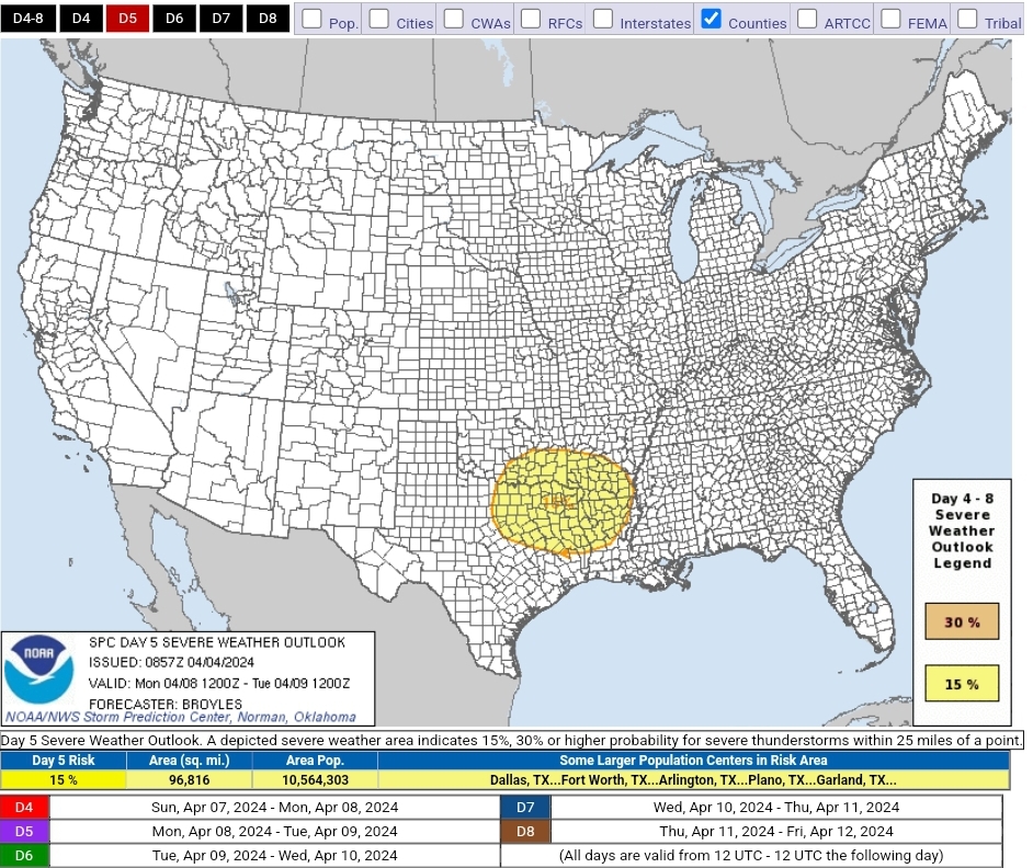

Severe Weather 4-8 through 4-11-24
in Central/Western States
Posted
Crazy to think we could be dealing with low clouds and severe t'storms tomorrow given dewpoints today mostly in the 20s & 30s.
But I guess that's the Plains for ya!