

Powerball
-
Posts
13,763 -
Joined
-
Last visited
Content Type
Profiles
Blogs
Forums
American Weather
Media Demo
Store
Gallery
Posts posted by Powerball
-
-
If any CWA is in the toughest spot right now headline-wise, I'd definitely say it's DTX.
Hypothetically, even if snowfall amounts for Metro Detroit were a more conservative 2-4" (instead of taking the current model output verbatim), snowfall rates could conceivably exceed 1" per hour and this would be happening right at rush hour with likely 20-30 MPH wind gusts.
-
Might have to watch that part of the line along I-20 / I-30 headed towards downtown. Looking pretty beefy on radar.
-
18 hours ago, cheese007 said:
Surprised to see a D1 hatched ENH centered on the ArkLaTex this morning. Then I saw it was Broyles and it made more sense.
 Still worth watching I guess...
SPC AC 110558

   Day 1 Convective Outlook
   NWS Storm Prediction Center Norman OK
   1158 PM CST Wed Jan 10 2024

   Valid 111200Z - 121200Z

   ...THERE IS AN ENHANCED RISK OF SEVERE THUNDERSTORMS ACROSS PARTS OF
   THE ARK-LA-TEX...

   ...SUMMARY...
   Severe thunderstorms, associated with tornadoes, wind damage and
   isolated large hail, are likely to develop across parts of the
   Ark-La-Tex this evening into the overnight. A severe threat is also
   expected to develop further south across parts of east Texas and
   Louisiana.

   ...Ark-La-Tex...
   An impressive upper-level system will translate quickly eastward
   through the Desert Southwest today, reaching the southern Plains
   this evening. Within the base of the trough, a 100 to 120 knot
   mid-level jet will move through west Texas this evening, as the nose
   of the jet overspreads the Ark-La-Tex. Ahead of the system, moisture
   will return northward across east Texas and Louisiana, with the nose
   of the moist sector reaching southern Arkansas by early evening. In
   response, a pocket of instability is forecast to develop across
   southeast Oklahoma, southwest Arkansas and northeast Texas, where
   convective initiation is expected during the mid evening.
   Thunderstorms are likely to rapidly increase in coverage during the
   late evening. Most hi-resolution models develop a line of strong to
   severe storms and move the line slowly eastward across southwest
   Arkansas and far northeast Texas during the early overnight period.
   As lift and shear increase due to the approach the mid-level jet,
   conditions are expected to become favorable for severe storms.

   Model forecast soundings across the Ark-La-Tex by 06Z have surface
   dewpoints near 60 F as far north as the Louisiana and Arkansas state
   line. Even so, MLCAPE should reach the 500 to 1000 J/kg range at the
   northern edge of the moist sector by late evening. Very strong lift
   associated with the exit region of the mid-level jet combined with
   low LCL heights and strong low-level shear should be favorable for
   supercells embedded in the line, and with the more discrete cells
   that develop ahead of the line. Some forecast soundings suggest that
   700-500 mb lapse rates will approach 8 C/km across the northern part
   of the warm sector. Although the large-hail threat should remain
   isolated, the steep mid-level lapse rates should be sufficient for a
   significant-hail threat. Hailstones of greater than 2 inches in
   diameter will be possible a few hours after cells initiation, as the
   storms mature. In addition, 0-3 km storm-relative helicity is
   forecast to peak near 400 m2/s2 in and just north of the Shreveport
   vicinity. This is also expected to support a tornado threat with the
   more intense supercells. Any supercell that can persist and become
   dominant may be able to produce a significant tornado or two. A
   wind-damage threat will also likely develop along the line of
   storms, with the greatest potential located across Ark-La-Tex, where
   an Enhanced risk has been introduced.

   ...East Texas/Louisiana...
   Further south into east Texas and Louisiana, storm coverage is
   expected to be more isolated from the late evening into the
   overnight period. In this area, to the south of the mid-level jet
   axis, instability is not expected to be as strong. Also, lift may
   not be quite as concentrated. For this reason, supercell development
   is expected to remain more isolated. Any cell that can become
   organized and sustained could produce isolated large hail, wind
   damage and a tornado or two. The severe threat should more isolated
   with southward extent, with only a marginal severe threat expected
   near in the coastal sections of southeast Texas and southern
   Louisiana.

   ..Broyles/Lyons.. 01/11/2024

   CLICK TO GET WUUS01 PTSDY1 PRODUCT

   NOTE: THE NEXT DAY 1 OUTLOOK IS SCHEDULED BY 1300Z
   CURRENT UTC TIME: 1111Z (5:11AM), RELOAD THIS PAGE TO UPDATE THE TIME
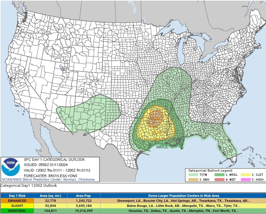
Seems Broyles might have gotten this one right.
Pretty impressive MULIs (over -10) and Mid-Level Lapse Rates (over 8 C/KM) right now.
-
Got a line ripping right over the Metroplex.
Not severe thus far, but frequent lightning and loud cracks of thunder.
-
 1
1
-
-
3 hours ago, Radtechwxman said:
When was the last time that model was right?
Believe it or not, GHD #1.
It was consistently the furthest NW / deepest / warmest the entire time and ended up being spot on.
-
2
-
 1
1
-
-
25 minutes ago, Snowstorms said:
I think @michsnowfreak would go nuts if he experienced 4 of the top 5 least snowiest winters on record in a period of 10 years like we did in Toronto from 2006-2016. And if so, he can pull out any historic stat but I know there's nothing as unprecedented as experiencing 4 futility winters in 10 years.
That being said, February's are not as favorable for snow for our region as January is in El Nino's, especially strong El Nino's. But thing's can always change. Like how rare it is to get two sub 980 Low's in 4 days that both end up being cutters in an El Nino.
Well, there was February 2010...
-
2
-
-
A part of me wants Detroit to see a winter of relative futility, just to see how @michsnowfreak would react.
I know if all else fails, February seems to always come through to save the day. That said, January so far isn't looking as hot as the broader pattern originally suggested for snow prospects in/around the Motor City (it's looking cold but dry)...
-
1
-
 1
1
-
-
1 hour ago, mississaugasnow said:
Ya, no different for the eastern lakes. Looking near identical to the system that just went thru. Bring back the December pattern haha
Amen to that!
-
4 hours ago, Stevo6899 said:
...I know he recently moved to Dallas but its not believable to have 10 hours of pingers no matter the location....
February 2-3, 2022 Winter Storm here in Dallas...
BTW, if the former Lafayette, IN members (Hoosier & ChicagoWX) were still actively posting, they could also attest to experiencing pingers for roughly the same length of time during GHD 2011. All of their old posts about the event are still easily searchable.
Point being, after experiencing such an event, I'm fairly numb to relatively intermittent pingers now. It can be so much worse.
-
4 hours ago, Stevo6899 said:
I am not your sweet summer child and I dunno what 10 hours you are referring to lol. While detroit always seems to get in on pingers, I don't recall having 10 hours of it. I remember ghd 11 was a few hours.
Oh boy...
I was just teasing you, my friend.
BTW, "Oh, My Sweet Summer Child" is an internet meme from The Game of Thrones, again meant to be a joke.
I will be more careful next time I respond...
-
 1
1
-
-
2 hours ago, icemiser said:
Sleet storms can actually be fun (not as much as ice of course). A 4” sleet storm has the staying power of 10-12” of moderate ratio snow. Not fun to hear, I get that.
^^^Another Palm Dude sock?
-
2 hours ago, Stevo6899 said:
Automatic F grade for winter when you hear pingers bouncing off your windows. For those receiving snow today, enjoy it
Oh my Sweet Summer Child...
Until you've had to suffer through the torture that is 10 straight hours of non-stop pinging on your windows, I feel no sympathy...

-
3
-
-
4 minutes ago, glacier said:
lock it in like jeffrey dahmer
Hi Palm Dude...
-
1
-
3
-
-
16 minutes ago, Stevo6899 said:
I guess I'm not around as much, but from what I saw he just liked to show off his love for warmth and palm trees. Nobody else in his life cared so he turned to here. I suppose not everyone has the tolerance to deal with trolls...
His trolling was funny at first, but after while his schtick started to get old.
-
1
-
-
21 minutes ago, Stevo6899 said:
It's a message board, not a workplace. Just ignore people that try to troll sometimes. Its not that hard. Not sure why we gotta threaten people on here.
That's the joy of WFH. You and you alone comprise of the "workplace."
-
 2
2
-
-
The elusive triple phaser has resurfaced...
-
1
-
-
5 minutes ago, dmc76 said:
The hills were that 1 degree colder. Most locals got over 10” some over 12”
4 minutes ago, Stevo6899 said:The point is that may be the only storm the past few winters that didn't end up weaker/se than what the euro depicted 4/5 days out. I think the fact that detroit had mixing issues is why I didnt recall that event.
But even during the event, I remember the models were still spitting out crazy amounts like a widespread 15-20".
Probably the rare instance where a storm didn't trend drier before the onset.
-
1
-
-
1 hour ago, michsnowfreak said:
3/3 was a wound up storm with blinding snow and lots of thundersnow in SE MI. Not a lot of cold air.
That's the one where, had it been like a half degree colder throughout the column, Detroit would have been buried in well over a foot of concrete.
In fact, before the mixing issues eventually happened (as dynamic cooling was doing its thing for a good minute), I recall DTX was strongly considering a Blizzard Warning.
-
1
-
1
-
-
lol at the 12z GGEM.
Ain't gonna happen...
-
One reason to be cautiously optimistic about this system delivering a high-end event is that, unlike the past several seasons, we finally have an active STJ with the borderline strong El Nino, which should help to keep the southern stream wave from shearing apart.
-
4
-
-
-
That EURO Control run is disgusting...

-
9 minutes ago, Powerball said:
I know. I'm mostly teasing.
In the process of moving, so I'm actually liking the dry/sunny weather we've had down here (even though it's been too cold for my liking).
If the broader pattern can stay the way it has been through at least the end of next weekend, I'll be a happy camper.
Ooof!!! I just realized this December is possibly on track for a top 5 warmest at DFW (even though it hasn't felt like it in the past week).
I've really lost my tolerance for non-Summer temps, lol...

-
1
-
-
13 minutes ago, CheeselandSkies said:
Certainly not grasping at it, just mentioning it. Verbatim a lot of the runs suggest (heavy) rain if anything for most of us. I'd be fine with armchair chasing a winter Dixie
 outbreak.
I know. I'm mostly teasing.
In the process of moving, so I'm actually liking the dry/sunny weather we've had down here (even though it's been too cold for my liking).
If the broader pattern can stay the way it has been through at least the end of next weekend, I'll be a happy camper.
-
1
-
Jan 11-13th Blizzard
in Lakes/Ohio Valley
Posted
Was Jim Cantore also live on scene?