-
Posts
13,820 -
Joined
-
Last visited
Content Type
Profiles
Blogs
Forums
American Weather
Media Demo
Store
Gallery
Posts posted by Powerball
-
-
4 minutes ago, michsnowfreak said:
We have actually had quite a few cold and snowy Novembers the last decade. Some of it is superstition, but a more recent trend is that you WANT the snow to hold off until December for the sake of a better winter.
I was going to ask you aboutt that and I'm glad you addressed it, because I figured (and I recall you saying in the past) there wasn't the greatest correlation historically between November weather and how winters end up.
Definitely gotta be careful with putting too much weight on any recent trends.
-
1 hour ago, IWXwx said:
 It appears that you are acclimated to living in the south. Correct me if I'm wrong, but isn't that the southern expression for dumbass?
IYKYK...

-
-
1 hour ago, michsnowfreak said:
Our depth here peaked at 15".
BTW...a friend of mine who lives in a brand new condo refused to turn the heat on until today. As his temp inside dropped to 60.
Bless his heart...
-
 2
2
-
-
On 9/1/2023 at 3:49 AM, Powerball said:
DFW Summer 2023 summary:
*3rd warmest on record with an average of 88.7*F (only behind 1980 and 2011)
*3rd highest average high on record of 99.4*F (only behind 1980 and 2011)
*3rd highest average low on record of 78*F (only behind 2011 and 2022).
*4th driest on record with only 1.25" of rain.
*Tied for 2nd driest August on record with only a T of precipitation (2000 is the driest with 0.00" precipitation).
*6th warmest July on record with average of 89.3*F
*2nd warmest August on record with an average of 92.9*F (only behind 2011).
*47 days (and counting) of 100*F+ highs, tied with 2022 (so far) for the 6th highest in a year.
*44 days (and counting) of 80*F+ lows, 2nd highest in a year (only behind 2011 with 55 days)
*Hit 110*F twice (8/25 and 8/26), first time since 8/2/2011 and both being the 2nd + 3rd latest ever observed (latest being 9/4/2000).
*6th highest number of consecutive 100*F+ days on record (tied with 2022).
*26 days (and counting) of 105*F+ highs, 2nd highest on record behind 1980 (so far) with 28 days.
*All-time record maximum low of 86*F tied twice (8/7 and 8/8).
*Longest streak of consecutive 85*F+ lows on record with 6 days total (previous 3 records all tied for 2 days in 2011).
*Longest consecutive duration of 80*F+ temps on record (previous record set in 1998 with 358 hours).
*Highest number of days with a heat index of 110*F+ on record
*Tied (with 1980) for the highest heat index ever recorded of 117*F.
*Tied for the highest dewpoint ever recorded (80*F) on 6/15, the 2nd earliest on record in a year (earliest being 6/14) and the highest on record since 1997.
Now that the 90s & 100s seem to be mostly gone for good (for sure after this Thursday)...
Revisiting this post, it's crazy how many records we set or tied this Summer, for it being mostly backloaded.
1980 and 2011 both still reign as kings, but this year was definitely a solid runner up behind the 2 by most measures.
And that doesn't even speak to September. I suspect JAS period was also amongst the warmest on record for DFW, similar to how MJJ was in 2022.
-
1 hour ago, Ed, snow and hurricane fan said:
Expected light show driving N on TX 249. None. Full bore thunderstorm, minus the thunder, winds probably gusting near 40 mph moving my car around, blinding rain. No thunder at all with the heavy rain. There was thunder with the light rain afterwards.
There wasn't much thunder here either. I heard maybe one good crack.
-
On another note, DFW overachieved temp-wise yesterday as it tied the record high of 96*F from 1898.
This was with quite a bit of cloud cover too.
-
It's going to be entertaining lurking and watching @hardypalmguy troll @michsnowfreak the next 6 months.
He's being a good sport about it though.
-
 2
2
-
 5
5
-
-
41 minutes ago, Stx_Thunder said:
Oh boy...
I definitely know your type on these places.
Respectfully, you can keep your snark to yourself.
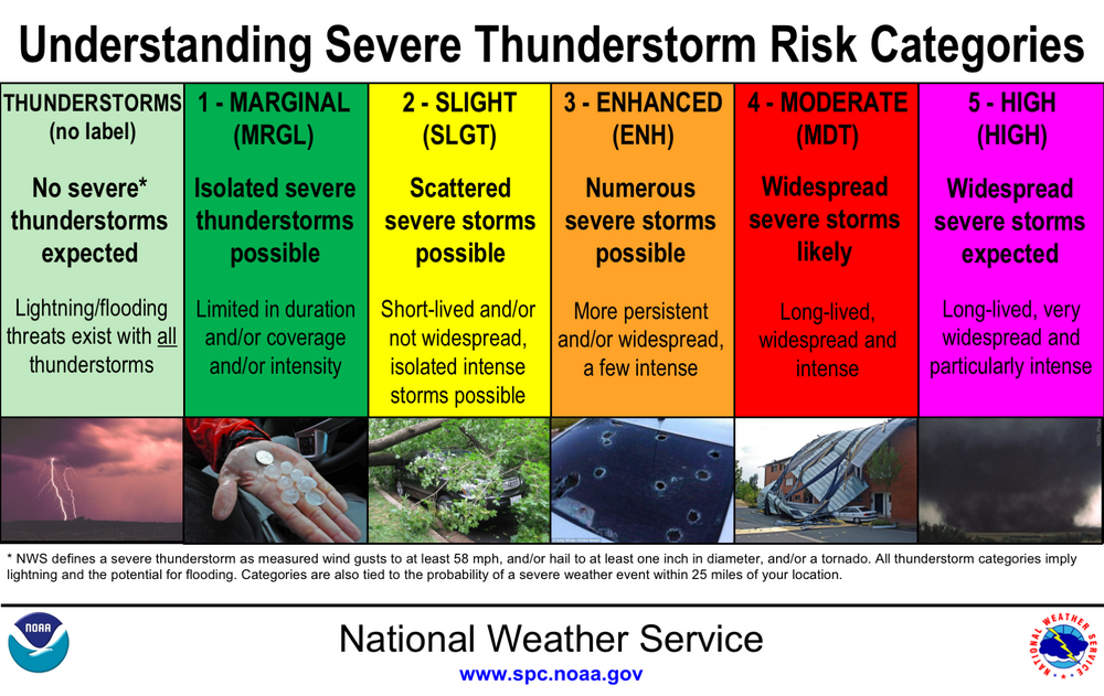
So an isolated part of the Metroplex saw 70+ MPH winds. Most areas did not. An isolated high-end report did not make enough justification for an enhanced risk outlook IMO. In fact, my take aligns exactly with the official SPC definitions:
I stand by what I said and you're free to feel whatever type of way about it.
-
Also, I will say, I did see widespread observations of wind gusts in the 35-45 MPH range, which (although sub-severe) is something.
And that was likely in part due to the somewhat lower than expected RH levels mentioned, as that helped to enhance the downdrafts a bit (though still not enough to overcome the cooling boundary layer).
-
1 hour ago, Stx_Thunder said:
- Bulk shear was nearing 50 kts (like the 12Z CAMs were showing by evening), effective shear nearing 60 kts, and Significant Severe value was passing 50 K at the time of the 0Z FWD sounding launch tonight, with virtually nil CIN of any kind.
Moisture was lacking a little with 60% RH in both lower and mid levels. So the boundary layer wasn't quite unstable as the lower to mid-level lapse rates dropped some during the day.
Outflow or frontal boundary also outran the storms as I saw on radar going through DFW which cut off some of the boundary layer or southerly lower level inflow into the cells. Had they not been undercut by the boundary, things would've likely been a bit more interesting severe-wise all around there.
Overall, it was a sufficient enough potential to justify the enhanced severe risk around DFW area with all the severe instances and warnings issued around there a while after dark, also taken into account.
Especially, the convective segment with 75+ mph measured gusts that literally came right next to Fort Worth metro as I also saw on base velocity next to 9:00 PM from the west.
Only 3 confirmed reports so far in DFW.
Granted, there may be more forthcoming, but in all likelihood still not enough to be enhanced risk worthy IMO.
Aside from that overachieving mini-bow echo that moved into FW proper (and actually weakened shorty thereafter), it's been largely "more bark than bite" severe-wise, with impressive shear on paper that didn't translate into a more impressive event. And that's pretty typical for these nighttime events in the Fall, which is why I didn't really buy into the hype.
That being said, it's certainly been a solid event rain-wise for the Metroplex and has been a prolific lightning producer.
-
30 minutes ago, Stx_Thunder said:
MUCAPE this morning is at 990mb. Which is literally just above the surface layer...I would in no way, consider that elevated.
Even with a stable near surface layer, if you have enough deep-layer or effective shear and support for lift going on aloft with a relatively unstable boundary layer, it can still promote stronger cells and higher wind gusts. Especially in a very linearly forced MCS or segment.
Since you replied toward me, the only other thing I'm going to add is SPC, especially on updated Day 1 outlooks, would not be highlighting your area in a large Slight risk if they knew the severe potential wasn't actually there. And, they've pretty much explained their reasoning with just about everything I wrote about the ongoing convective parameters in here. It's not just about what the conditions are at or near the surface (or how unstable/stable it is in that layer alone in your case). Elevated supercells also do actually exist.
On the contrary, from all my convective analysis experience over the years, it has a lot more to do with the boundary layer when it comes to instability. And even with limited instability overall, it still does not mean severe can't happen at all (and has before). Even SPC talks a lot about all of these things too, reading their discussions frequently over the years.
Also, they've expanded the enhanced risk area much closer to you now in the late morning update.
The severe threat is definitely there. I just disagree that it's great enough for an upgrade to an enhanced risk (as you seem to) for DFW.
The better potential will be NW of here, where the activity will occur during or just after peak heating.
-
9 minutes ago, Stx_Thunder said:
Despite the lower CAPE on this morning's sounding, I wouldn't say that's marginal instability up there in DFW given the already fairly weak inhibition, 700mb - 500mb lapse rates already up at 7 C, a 70 F + surface dew point (which I would think is pretty high for this time of year up there in October), and already almost 35 kts Effective shear, and nearing 100 kts cloud shear now.And, the forecast of no real MLCINH on CAMs around there through the evening.
Craven/Brooks SigSevere already at 20,000 also. Which will likely increase through the day just like the shear values with the upper trough obviously getting closer. BRN low, but will probably go up later today with lower-level flow veering and increasing from the south-southeast.
Plus, 12Z CAM runs like the ARWs this morning are pushing back on the main and pretty sharp convective line further into the evening compared to yesterday evening runs. This could be an indication of the upper trough deepening/slowing down.
---
At this point, it looks like a close call looking at the latest data and parameters this morning as more would seem to favor it later today than not (despite it being a nocturnal event).Especially if there's a potent incoming mid-level shortwave involved (like SPC is talking about today). If there isn't or timing is off with the stronger dynamics coming in this evening, then severe would be less likely around there.
To clarify, the reason I say somewhat marginal instability for severe weather is because much of that instability on the sounding you presented is elevated. Even the CAMs indicate a stable layer forming near the surface by the time the storms arrive into DFW (temps only in the low 80s and dewpoints in the low/mid 70s), which will significantly temper downburst potential.
Instability and moisture levels are definitely good enough for prolific rain producers and frequent lightning though, which is already pretty well covered in the current outlooks/forecasts.
-
21 minutes ago, Stx_Thunder said:
- SPC finally getting their act together. Wouldn't be surprised if they expand that enhanced risk into or near the DFW area this afternoon due to more significant damaging wind gusts or hail events (given the upward of 60 kt shear CAMs are showing in that region by this evening).
Probably a good mid-level shortwave coming into the mix too given how deep that incoming upper level trough probably is also. Can't really underestimate these EN Fall systems. Especially being still pretty early in the season.
Not going to happen due to less than ideal timing (late evening hours) and already somewhat marginal instability with an unimpressive dewpoint/temp spread, likely preventing much of that shear from mixing down to the surface.
The enhanced risk is mainly for very large hail (2-3"+) with the initial activity.
-
In all likelihood, this September will end up being the 2nd warmest on record for DFW.
Only September 2019 was warmer.
-
2 hours ago, michsnowfreak said:
Tired of the heat yet?
DFW 113 days 90+ this year, max 110
DTW 2 days 90+ this year, max 90
I'm good, as the trade off will be not having to deal with never-ending freezing temps a couple months from now.
-
 2
2
-
 1
1
-
-
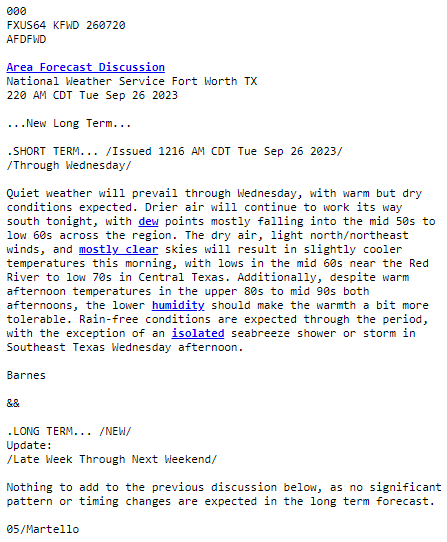
One of the shortest and sweetest AFDs I've ever seen.

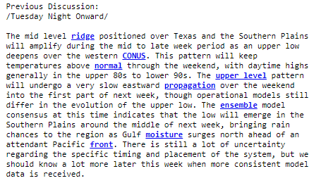
And the previous discussion for reference:

-
 1
1
-
-
5 hours ago, CheeselandSkies said:
Remnants of Idalia didn't come anywhere near Wisconsin. It headed east back out over the Atlantic.
.gif.85857603b61ac18d0fb7fd11ce9ef19b.gif)
-
 1
1
-
 3
3
-
-
Welp, the 80s that were in the forecast went POOF.
But we seem to be finally done with the 100s, lol...
-
8 hours ago, Powerball said:
It's finally my turn. Ton of CTG lightning.
Ending uo getting no more rain more other than the 30s seconds of fat raindrops from earlier yesterday afternoon.
-
It's finally my turn. Ton of CTG lightning.
-
 1
1
-
-
In the mean time, DFW made it to 101*F for the 2nd day in a row, another record...
-
For what little it's worth. Radar/satellite look quite underwhelming thus far...
-
Just got a bunch of fat raindrops for about 30 seconds. Was enough to dampen the ground and make a few puddles.
Fortunately, most of this weak sauce crap percolating seems to missing the airport, so another 100*F high should still be on the table.


Autumn 2023 Banter Hangout
in Lakes/Ohio Valley
Posted
If you listened to WWJ (950 AM) during the afternoon rush in the 2000s, Sonny Eliot was the regular on-air metereologist. This was long after he had retired from TV (he was the Chief Meteorologist at WDIV until the late 70s).
While he was a fine weatherman, he wasn't nearly as revered as Tom Skilling has been for his technical expertise. It was more so his personality and eccentric way of delivering forecasts that won him favor with his audience. What was unique about him was that he was always perky on-camera (although I heard he was kind of difficult to work with behind the scenes), cracking jokes and speaking in riddles.
https://youtu.be/0WyBMhnmGb8?si=Mz1fmA1iaEGLbCmm