

Powerball
-
Posts
14,270 -
Joined
-
Last visited
Content Type
Profiles
Blogs
Forums
American Weather
Media Demo
Store
Gallery
Posts posted by Powerball
-
-
1 hour ago, Powerball said:
DFW has at least tied the record high of 82°F today.
83°F was the official high at DFW, breaking the previous record of 82°F set in 1905...
-
DFW has at least tied the record high of 82°F today.
-
Tornado Watch has been dropped for the western half of DFW...
-
Quiet as its kept, might have a flash flood episode setting up for parts of DFW too...
-
27 minutes ago, TXHawk88 said:
Let’s see how this all unfolds
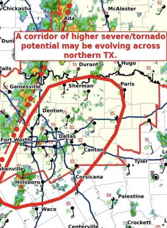
Might have spoke too soon.
Things are looking more messy on the latest radar frames, and the active warnings have ended -
It's getting pretty randy just SW of DFW now...
-
-
-
The more I look over everything, today is feeling like a somewhat underhyped setup...
-
 1
1
-
-
Tomorrow's record high for DFW is 91*F, which is also the forecast high.
-
15 minutes ago, A-L-E-K said:
P good signal for a mega torch coming
The only thing that could throw a wrench into things would be the potential formation and recurving of a typhoon in the western Pacific.
There'a a decent signal for that (although not a lock just yet) too.
-
 2
2
-
-
As things stand now, October is on track for the warmest on record for DFW...
Also, crazy as it might be, DFW may have a legit shot at finishing the month with no precip (obviously also being the driest on record).
-
1
-
-
Getting walloped right now with a severe t'storm.
Power went out briefly then popped back on for now, and had some large hail for a brief moment.
-
 1
1
-
-
DFW set a record maximum low of 79*F yesterday.
-
Interesting tidbit from FWD this morning...
All
available perfect-prog guidance projects 500mb temperatures above
the Dallas/Fort Worth Metroplex will rise above -1C (into the 30s
in Fahrenheit) on Friday. The NAM has 500mb temperatures above
freezing! This isn`t just near-record for September but would
challenge the all-time record high 500mb temperature for our local
weather balloons (1950 to present), which is -0.5C from July 1951.
-
With August 2024 having come to a close, 2024 was the 16th hottest Summer on record for DFW with an average temp of 86.0°F and the 10th hottest August on record with an average temp of 88.9°F.
While not nearly on the level of 2023, 1998, 1980 or 2011 hot, it was still up there with 1999, 2012 and 2018 in terms of overall intensity as well as 2.1°F above average.
August 2024 did tie with August 2010 for the 16th driest on record as well (with only 0.41" of precip).
-
12 hours ago, SolidIcewx said:
Kinda surprised they fizzled out on their way to the metro
Given some folks are still without power and clean up is still ongoing from the storms a few days ago, that was probably for the best.
-
On 8/29/2024 at 8:43 AM, michsnowfreak said:
March 2012 was obviously impressive, but I don’t recall any 90s in MI. The hottest temps in MI at the first order stations were: 86F at Detroit, 86F Flint, 87F Saginaw, 87F Alpena, 83F Sault Ste Marie, 85F Houghton Lake, 81F Marquette, 87F Grand Rapids, 86F Lansing, 82F Muskegon.
With that said, March 2012 gets talked about plenty (rightly so), but I dont feel Feb 2015 gets NEAR its due. We do talk about the snowy/harsh winters of the time, but rarely is Feb 2015 singled out for its brutal cold, whereas March 2012 is brought up everytime orange shows up on a model map after Feb 1st.
At DTW:
Mar 2012: Monthly departure: +13.5F. Highest daily departure: +31F
Feb 2015: Monthly departure: -13.9F. Highest daily departure: -29F (3 times).Besides everything stated above, another reason why Feb. 2015 isn't brought up as much is because perisistent extreme cold isn't nearly as pleasant to reminsce about as temps in the 70s & 80s
-
 1
1
-
-
1 hour ago, michsnowfreak said:
This summer was mostly pleasant here. In fact it should have been way hotter than it was. La nina summers, especially summers that transition from nino to nina, are traditionally scorching hot, which I was bracing for. Simply didn't happen. @mississaugasnow I was close in my guess. DTW hit 95 yesterday, which ties as the hottest temp of the year.
Part of the reason for that, if we're getting technical, is because the actual Nina transition has failed to happen thus far. We're still officially in a neutral ENSO state as the transition has been much slower than originally predicted.
-
1
-
-
I see the Detroit area got rocked (DTW recorded a 76 MPH gust).
I talked to my mom and she said there are down branches everywhere.
-
This Summer is likely on track to be a top 20 warmest for DFW (in addition to this being a top 10 hottest August). Also, a large part of North Texas is now under moderate drought conditions.
I know after 2022 and 2023, this year feels milquetoast in comparison (especially with the mild July). But yeah, statistically, the records will reflect it was another hot one with an impressve turnaround on both the precipitation (especially with the surplus we had as of early June) and temp front...
Can't help but wonder how much worse it would have been without the unusually early start to the season we had for global tropical activity in the first half of July.
-
Today marks the 14th 100°F+ day of the year for DFW.
In all likelihood, it's the start of a decent streak.
-
The summer hasn't been all that hot (relative to average) thus far, but if the 00z GFS is to believe, a brutal 2nd half of August will definitely help to make up for it.
-
The 100s are officially back, as DFW achieved an intra-hour high of 100*F today (9th for the year so far).
Could potentially be looking at a 7+ day streak too.

Texas 2024 Discussion/Observations
in Central/Western States
Posted
For DFW:
With November having officlally ended, it was the 8th warmest on record with an average temp of 61.7°F.
Also, Fall 2024 was the 3rd warmest on record with an average temp of 72.2°F.