

Powerball
-
Posts
14,286 -
Joined
-
Last visited
Content Type
Profiles
Blogs
Forums
American Weather
Media Demo
Store
Gallery
Posts posted by Powerball
-
-
19 minutes ago, WeatherMonger said:

Although not PDS, still pretty high end for a TOR Watch.
-
41 minutes ago, CheeselandSkies said:
I wonder if it will be a PDS watch...
-
CU field starting to develop in SE Nebraska and Central Kansas.
-
Got a few DFW sites reporting gusts over 50 MPH right now.
Pretty widespread 35 - 45 MPH gusts though.
-
The western 2/3rds of Iowa and much of far eastern Nebraska looks to have clear skies now.
-
23 minutes ago, CheeselandSkies said:
Ah. I was focused on the moderate/enhanced.
Actually, taking another look, they did expand the Moderate Risk areas a bit further SW to include Omaha and far east central Nebraska.
-
On 12/12/2021 at 3:01 PM, stormdragonwx said:
I have apparently started up a sh*tstorm over on this site regarding the above statement. Gotta love the general public.
 These are probably the same people that throw fits over severe weather coverage breaking in on the TV.
EDIT: lol They banned me so I couldn't respond after sending some personal insults my way. Apparently dissenting opinions are not allowed.
Sometimes, you just gotta learn how to read the room.
I doubt a bunch of theme park enthusiasts care about the intricate weather details you wanted to discuss
-
1 minute ago, CheeselandSkies said:
Doesn't appear SPC made any substantial changes to probability outlines at 1630.
Lower MI and far eastern IL were removed from the general thunder area, but that's about it.
-
Unless there's shallow low clouds I'm not seeing, there's pretty good insolation right now over SE Nebraska and SW Iowa.
-
Apparently, this is also the first Moderate Risk ever in this area in December...
-
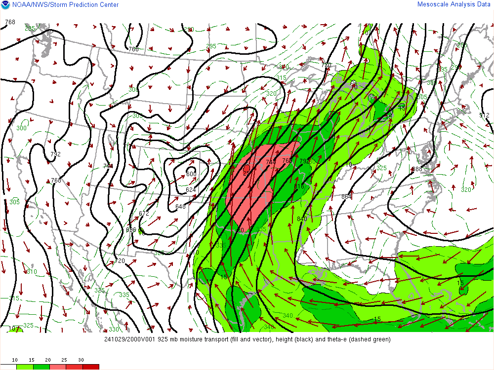
One concern I did have about this event was moisture return, but dewpoints are already ~60°F into Iowa. That should only go up further aa the LLJ strengthens and the trough amplifies...
-
6 minutes ago, CheeselandSkies said:
Socked in with fog/low stratus here in Madison. Vis sat appears to show some thinning/clearing over much of Iowa. Not that insolation is a major factor this time of year but any that does happen will only help the thermos overperform more. Might also allow the synoptic winds to mix down more.

-
1 minute ago, tim123 said:
Anyone know what these streaks on 3km nam are? Never seen them.

It's where the models are picking up strong rotation as the cells move through.
-
6 hours ago, hlcater said:
Wind driven moderate with a 10% tor. Did not expect that.

I called it back on Sunday. A lot of similarities to the severe weather setup tonight with this past Saturday/Sunday.
At least this time around, the heightened threat level is being a lot more hyped earlier. Perhaps this will convince more people to be more dilligent about monitoring the weather conditions this evening.
-
 1
1
-
-
Just now, Powerball said:
Well alrighty then...
Mesoscale Discussion 1981
   NWS Storm Prediction Center Norman OK
   0420 PM CST Fri Dec 10 2021

   Areas affected...Northeast Texas...far southeast Oklahoma...and far
   southwest Arkansas

   Concerning...Severe potential...Watch possible

   Valid 102220Z - 102345Z

   Probability of Watch Issuance...40 percent

   SUMMARY...Isolated to widely scattered severe storms are possible
   across portions of the Arklatex.

   DISCUSSION...High based showers have developed along a dryline which
   has recently passed through Dallas. These showers are now moving
   into a more moisture rich airmass with dewpoints in the mid 60s.
   This is yielding MLCAPE around 1500 to 2000 J/kg beneath strong
   mid-level flow and effective shear in excess of 60 knots. Therefore,
   further intensification of these showers are possible. The threat
   will likely remain isolated, but the environment is quite favorable
   for supercells with an initial large hail threat with an increasing
   tornado threat with eastward extent. The isolated nature of any
   storm development may preclude the need for a watch, but if storm
   intensity is great enough or if more storms develop, a watch may be
   needed.

   ..Bentley/Grams.. 12/10/2021

   ...Please see www.spc.noaa.gov for graphic product...

   ATTN...WFO...LZK...SHV...TSA...FWD...OUN...

   LAT...LON   33279692 34019584 34579457 34189338 33319365 32189491
               31809694 31979759 33279692
Severe Thunderstorm Warning TXC085-231-397-102330- /O.NEW.KFWD.SV.W.0274.211210T2243Z-211210T2330Z/ BULLETIN - IMMEDIATE BROADCAST REQUESTED Severe Thunderstorm Warning National Weather Service Fort Worth TX 443 PM CST Fri Dec 10 2021 The National Weather Service in Fort Worth has issued a * Severe Thunderstorm Warning for... Northwestern Rockwall County in north central Texas... Central Hunt County in north central Texas... Southeastern Collin County in north central Texas... * Until 530 PM CST. * At 443 PM CST, a severe thunderstorm was located over Fate, or near Rockwall, moving northeast at 50 mph. HAZARD...60 mph wind gusts and quarter size hail. SOURCE...Radar indicated. IMPACT...Hail damage to vehicles is expected. Expect wind damage to roofs, siding, and trees. * Locations impacted include... Wylie, Rockwall, Greenville, Commerce, Royse City, Fate, Farmersville, Wolfe City, Caddo Mills, Celeste, Campbell, Mobile City, Lavon, McLendon-Chisholm, Nevada, Josephine and Neylandville. This includes Interstate 30 between mile markers 68 and 100. PRECAUTIONARY/PREPAREDNESS ACTIONS... For your protection get inside a sturdy structure and stay away from windows. && LAT...LON 3284 9643 3300 9652 3338 9610 3341 9586 3324 9586 TIME...MOT...LOC 2243Z 227DEG 43KT 3298 9640 HAIL THREAT...RADAR INDICATED MAX HAIL SIZE...1.00 IN WIND THREAT...RADAR INDICATED MAX WIND GUST...60 MPH $$ Gordon -
Well alrighty then...
Mesoscale Discussion 1981 NWS Storm Prediction Center Norman OK 0420 PM CST Fri Dec 10 2021 Areas affected...Northeast Texas...far southeast Oklahoma...and far southwest Arkansas Concerning...Severe potential...Watch possible Valid 102220Z - 102345Z Probability of Watch Issuance...40 percent SUMMARY...Isolated to widely scattered severe storms are possible across portions of the Arklatex. DISCUSSION...High based showers have developed along a dryline which has recently passed through Dallas. These showers are now moving into a more moisture rich airmass with dewpoints in the mid 60s. This is yielding MLCAPE around 1500 to 2000 J/kg beneath strong mid-level flow and effective shear in excess of 60 knots. Therefore, further intensification of these showers are possible. The threat will likely remain isolated, but the environment is quite favorable for supercells with an initial large hail threat with an increasing tornado threat with eastward extent. The isolated nature of any storm development may preclude the need for a watch, but if storm intensity is great enough or if more storms develop, a watch may be needed. ..Bentley/Grams.. 12/10/2021 ...Please see www.spc.noaa.gov for graphic product... ATTN...WFO...LZK...SHV...TSA...FWD...OUN... LAT...LON 33279692 34019584 34579457 34189338 33319365 32189491 31809694 31979759 33279692 -
9 hours ago, luckyweather said:

Clown map
-
38 minutes ago, michsnowfreak said:
Lol I wouldn't say it's going to be hot and dusty.
Knowing Detroit, it's going to be grungy regardless of the temp.
-
^^^Of course, it works out for places like Detroit, because strong negative tilt cutters would more likely end up being rainers for them.
-
 1
1
-
-
58 minutes ago, Chicago Storm said:
The shift towards positive tilt junk has been significant the lastday or two.10 years or so
So unless that potential comes back, or Thursdays event up north in MN/WI/MI ends up further south, it might be about time to ring the futility bells.
.fyp.
-
 1
1
-
-
Off to a rocking start...
(BTW, record high is in the upper 80s).

-
 2
2
-
-
23 hours ago, Thundersnow12 said:
Was told the -PNA was gonna be rockin’
Not your best call
Why don't you have a Met tag? I remember you going to school for that.
(serious question)
-
 1
1
-
1
-
-
DFW ended up +1.3*F above average for November.

-
2 hours ago, RogueWaves said:
The actual wx changed their minds lol. 3pm AFD's only reason not to was due to it being post rush hour. Since when is that the only time of day worth warning Peeps that dangerous driving is likely. Besides, tons of folks work non day shift jobs. It sounded like GRR logic when I read it. Glad somebody thought twice about it. Snow-on-snow in November. Did they relocate Motown to NMI when I wasn't looking??
I mean, we had snow-on-snow in *Texas* this past February. So nothing surprises me any more, lol...
-
1
-


December 15th-16th Warmth, Wind, and Severe Threat
in Lakes/Ohio Valley
Posted
https://twitter.com/KathrynProciv/status/1471087134861930508?t=tr2yUJoFfeTw7aLYVg9EJQ&s=19