

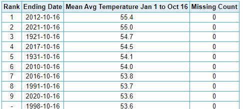
Powerball
-
Posts
14,286 -
Joined
-
Last visited
Content Type
Profiles
Blogs
Forums
American Weather
Media Demo
Store
Gallery
Posts posted by Powerball
-
-
5 hours ago, RogueWaves said:
Unfortunately, it's a pattern of cold NW flow mostly moisture starved clippers, and the risk is when/if it flips (nothing locks all winter) we end up on the warm side of hard cutters. Tbd ofc, but this gradient is very much like Dec 2017 so far.
If I remember correctly, 2017 was the year that Detroit saw the Christmas snowstorm.
-
 1
1
-
-
Not really getting strong wind gusts, but pretty erratic wind shifting.
-
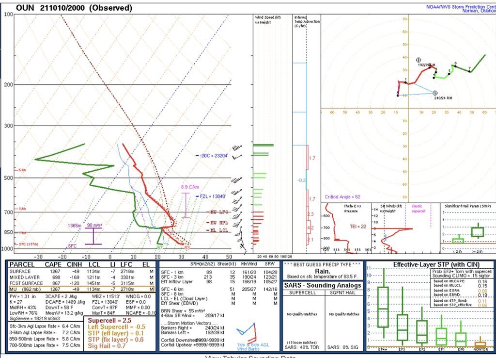
Mesoscale Discussion 1937 NWS Storm Prediction Center Norman OK 0506 PM CST Wed Nov 10 2021 Areas affected...parts of north Texas Concerning...Severe potential...Watch likely Valid 102306Z - 110100Z Probability of Watch Issuance...80 percent SUMMARY...Storms capable of damaging hail, strong gusts and perhaps a brief tornado are expected to affect parts of north Texas this evening. DISCUSSION...Surface analysis shows a cold front from central OK into northwest TX, with a dryline from near Wichita Falls extending southwestward toward San Angelo. While dewpoints are only in the 55-60 F range, temperatures aloft are quite cold which is maximizing instability. A 21Z sounding from OUN showed 2000 J/kg MUCAPE, despite little heating today. Visible imagery shows towering CU near the cold front/dryline intersection approaching the Wichita Falls area. One or more supercells may eventually form out of this area, with storms forecast to progress east/southeastward this evening. Lengthening hodographs as well as steep lapse rates aloft with 500 mb temperatures near -17 C suggest damaging hail will be possible as storms move east/southeast along and south of the Red River. A brief tornado may occur as well, as low-level shear remains favorable prior to the cold front passing. However, low-level winds are forecast to rapidly veer this evening. ..Jewell/Edwards.. 11/10/2021 ...Please see www.spc.noaa.gov for graphic product... ATTN...WFO...SHV...TSA...FWD...OUN... LAT...LON 34289674 34109555 33929504 33529492 33029494 32659544 32429606 32389696 32479793 32579891 32849899 33269877 33689878 34259895 34499858 34429769 34289674 -
14 minutes ago, Witness Protection Program said:
Well dang, so we're going to get another round tonight in DFW after this line that is currently rolling through.
Any chance this current line will lessen the tornado risk for tonight's main event for DFW?
If anything, the subsidence behind this initial line might help to keep the cells later this evening discrete longer.
-
1
-
-
15 minutes ago, Powerball said:
Looking at the clouds, you can actually see the updrafts trying their damndest to break throigh the cap as the initial line of showers moves through and instability/moisture advection picks up.
There's some lightning strikes showing up within it in OK I see...
Lightning's showing up now over DFW, hearing thunder here.
-
Looking at the clouds, you can actually see the updrafts trying their damndest to break through the cap as the initial line of showers moves through and instability/moisture advection picks up.
There's some lightning strikes showing up within it in OK I see...
-
1 hour ago, Iceresistance said:
Very strong concern for my area (Central Oklahoma), SE Oklahoma, & Southern Oklahoma tonight. the SPC is calling for a higher chance of Tornadoes, up to Tennis Ball sized hail & 70 mph wind gusts.
It appears that the area of Highest Instability is along & east of I-35, along & south of I-40, along & west of US-75 or US-69, & along & north of US-70.CAMs are showing mixed signals at best for DFW. Some of them are, in fact, duds.
So highly conditional setup here, but yeah, could be an active evening up in Central/Southern OK for sure.
EDIT: It's crazy that we're seeing a lot more severe weather threats/events this fall than we saw during the entirety of our actual severe weather season.
-
It seems October 2021 will tie (with 1988) for the 4th warmest on record for Detroit.
-
Looks like Detroit might be on track for a top 5 warmest October on record, and possibly the warmest October it's seen in nearly 100 years. Current departure is 60.1*F, and it would need to stay above 59.5*F to make the top 5.
Even down here, we're looking at a top 10 warmest October on record.
-
Apparently, we had a rogue t'storm come through a little while ago (I was asleep).
It doesn't seem to have been severe though. -
On 10/18/2021 at 9:01 PM, StormfanaticInd said:
Joe Bastardi is one of our greatest minds even though he can be a bit biased
I think you forgot to add your sarcasm tag there...
-
 2
2
-
-
On 10/17/2021 at 1:42 PM, TheClimateChanger said:
Also, the second warmest year to date in Chicago. Might as well root for a mild end to the year to unseat 2012.
The real story there is that 6 of the top 10 warmest years have all been in the last 11 years, and all but 1 of the top 10 warmest years have been in the last 30 years.
-
2
-
-
-

Mesoscale Precipitation Discussion 1082 NWS Weather Prediction Center College Park MD 1231 PM EDT Wed Oct 13 2021 Areas affected...southwest into west-central Texas Concerning...Heavy rainfall...Flash flooding possible Valid 131631Z - 132231Z Summary...Onset of a long-duration flash flood threat is underway across the discussion area. Discussion...Latest observations and objective analyses indicate a nearly surface boundary extending from near 6R6 (near the Big Bend region of Texas) east-northeastward to near the Dallas/Fort Worth Metro area. Along and southeast of the front, abundantly moist and unstable air was supporting scattered showers and thunderstorms near the front that were increasing in coverage and intensity this morning. Flow aloft was southwesterly - generally parallel to the front - which was already allowing for some training especially near the convective band about 70 WSW of SJT. Areas of 1"/hr rates were already noted, which is not particularly surprising given 1.5-1.9 inch PW values along and ahead of the front. Over the next 6 hours (and potentially beyond), models depict a gradual expansion of convective coverage primarily due to weak confluence/convergence along and ahead of the front. The approach of moisture/lift associated with Tropical Cyclone Pam along the western coast of Mexico will also contribute to expanded convective coverage over time as well. FFG thresholds are generally in the 2-3"/hr range across most of the discussion area (slightly lower near the Austin/San Antonio corridor), suggesting that the greatest flash flood threat will be tied to areas that can experience training and/or persistence of heavy rainfall in the near term. Cook ATTN...WFO...EWX...FWD...MAF...SJT... ATTN...RFC...WGRFC...NWC... LAT...LON 32689805 32479765 31719781 30789875 29679955 29130038 29300089 29560173 29570234 29690269 30450231 31190151 32489919 -
-
13 minutes ago, ouamber said:
Coweta tornado has hit the high school!
Crazy that in the same season, we've had the high schools in 2 different places named Coweta destroyed by a strong nighttime tornadoes.
-
 1
1
-
-
Also per KDFW news, there were over 50K power outages across DFW at the peak, but things seem to be getting restored quickly.
-
DFW measured a 70 MPH wind gust per the SPC, with numerous 60-70 MPH gusts around the greater Metroplex area.
EDIT: DAL also reported a 56 MPH wind gust per KDFW news.
-
5 minutes ago, cheese007 said:
Power just went out Dallas county
Still got power here.
-
1
-
-
Surprised they issued a Tornado Watch as quickly as they did and for such a large area in North Texas
It's in effect until 2am.
-
14 minutes ago, jpeters3 said:
I doubt this will have much of an effect on things. The really shallow high Td layer near the surface would "mix out" anyway as air parcels ascend through the boundary layer into updrafts. What really matters is the average PBL moisture.
True, but I suspect it explains why the CINH hasn't eroded as quickly as the CAMs progged.
-
It seems the problem is that dewpoints are now starting to mix out. They've fallen into the mid 60s here.
-
23 minutes ago, OhioWX said:
Special 20z OUN sounding. Once that cap erodes...
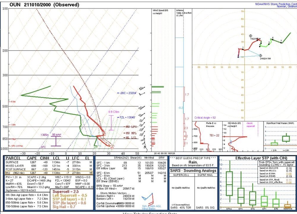
FWD's sounding isn't much better...

-
For what little it's worth though, I think today's event is the first time this entire season that every short-term CAM has agreed on a single outcome, and they all look good for DFW.
-
2
-


Southern Plains Winter 2021-2022
in Central/Western States
Posted
Although it was a roller coaster month and much cooler than October, November's still on track to be above average here in DFW.
In fact, highs for the next 2 days to end the month will be 10+ degrees above average.