Powerball
-
Posts
14,464 -
Joined
-
Last visited
Content Type
Profiles
Blogs
Forums
American Weather
Media Demo
Store
Gallery
Everything posted by Powerball
-
And it's all relative too. Even an oppressive Summer (ala 2011 or 2012) for the Detroit area would be considered cool for the Deep South and Desert SW...
-
*Laughs in Texas*
-

Texas 2025 Discussion/Observations
Powerball replied to Stx_Thunder's topic in Central/Western States
With an average temp of 64*F, 2025 was the 6th warmest March on record for DFW... -
Warnings for 80 MPH winds in Genessee and Oakland Counties..
-
Warning for Detroit now, 70 MPH winds...
-
Texas 2025 Discussion/Observations
Powerball replied to Stx_Thunder's topic in Central/Western States
Welp, aside from the freak FW storm that collapsed just as fast as it blew up, this afternoon's Watch is turning out to be a bust... -
Can confirm from experience, 80 MPH straight-line winds fortuantely don't cause much nearly as much destruction with bare trees vs. full leaf out.
-
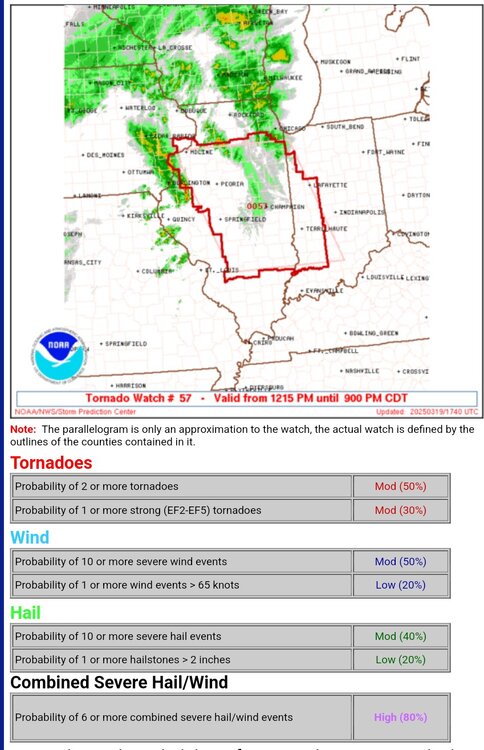
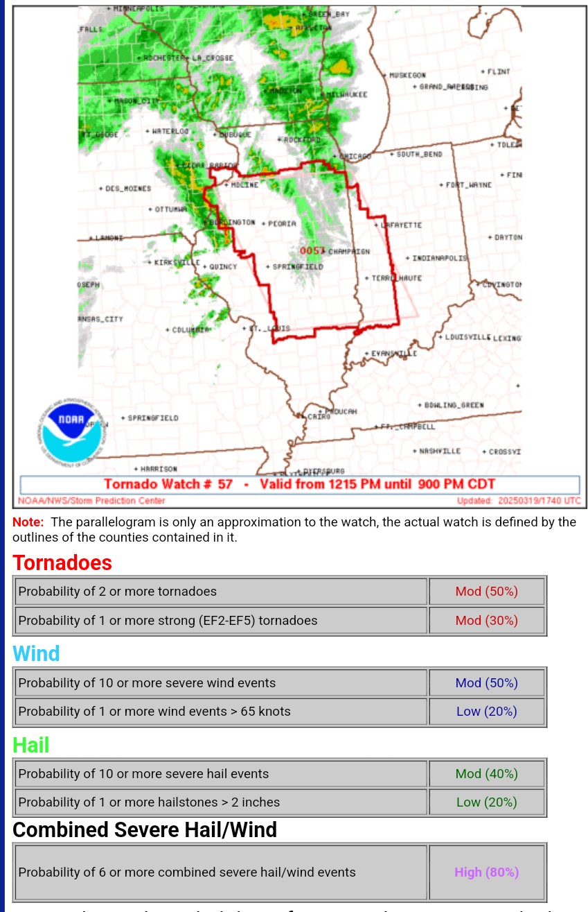
Severe T'Storm Watch in effect until 10pm... https://x.com/NWSSPC/status/1906457674717212685?t=XgQU6Y1_P2H4Dk-JDbKrGA&s=19
-
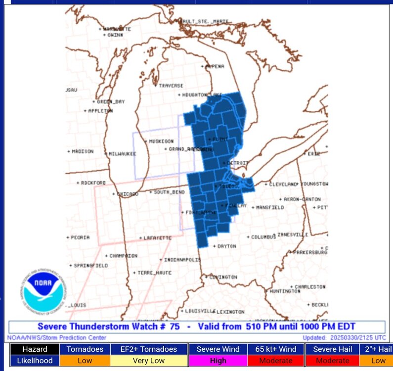
https://x.com/NWSSPC/status/1906402317005422997?t=SZ2bpund_HP6E8IJOlQ2jw&s=19
-
No one can hype up an event like Roger...
-
Texas 2025 Discussion/Observations
Powerball replied to Stx_Thunder's topic in Central/Western States
DFW did officially make it to 90*F for the first time this year. Also, it's the hottest day of the year, thus far. Not quite a record high though (that's 97*F). DFW has another shot at hitting 90*F on Saturday. -
Texas 2025 Discussion/Observations
Powerball replied to Stx_Thunder's topic in Central/Western States
DFW has a shot at its first 90*F day on Tuesday. -
Spring 2025 Medium/Long Range Discussion
Powerball replied to Chicago Storm's topic in Lakes/Ohio Valley
That's definitely what all signs point to. But not before parts of TX get a bit of drought relief. -
Spring 2025 Medium/Long Range Discussion
Powerball replied to Chicago Storm's topic in Lakes/Ohio Valley
I'm pretty sure it was just another PV stretch (the final one for the season as the PV dissipates) which don't always translate to severe / lasting cold spells. SSWE, like Polar Vortex in the context of winter storms, is grossly overused terminology in weather discussions (but especilly by one Met in particular). -
Spring 2025 Medium/Long Range Discussion
Powerball replied to Chicago Storm's topic in Lakes/Ohio Valley
^^^How lovely... -
Fall/Winter '24 Banter and Complaints Go Here
Powerball replied to IWXwx's topic in Lakes/Ohio Valley
Not quite, but close... 2024 = +4.3 2023 = +1.3 2022 = -2.1 2021 = +1.7 2020 = -2.8 2019 = +0.1 2018 = -5.9 2017 = +5.4 2016 = -2.6 2015 = +1.1 -
I'll take intermittent haboobs over days on end of lake-effect clouds and wrap-around stratocumulus in the Spring/Fall. #BlessTheSunbelt
-
Do you hear me complaining? #BestClimo
-
Unless the post-storm surveys indicate otherwise, the SPC has those spotter reports on the record as tornadoes (total of 9 reports yesterday).
-
There's also the whole Skywarn Training initiative where once you actually attend a full session in-person to learn all the technical ins & outs with storm reporting, they'd give you a "private" number & email number and implore you not to share it with anyone. But of course, humans being humans, people share it any way.
-
There's no foolproof way for the NWS to control who reports something and who doens't. That said, the onus should be on the NWS to discern the legitimacy of a report before confirming it.
-
The transluscence of the dust with dense cloud cover is something...
-
Well of course, for enhancement, the overall background environment still has to be favorable for convective development.
-
https://x.com/philipnation/status/1902391058736017607?t=9qgA-QqG2jZeawo6epgAsQ&s=19
-