Bob Chill
-
Posts
36,386 -
Joined
Content Type
Profiles
Blogs
Forums
American Weather
Media Demo
Store
Gallery
Everything posted by Bob Chill
-
1.5" with continued light to brief bursts of mod snow. Temp steady at 14 degrees. CC radar showing some sleet dancing around to my south but no major line yet.
-
3k nam said I would have nothing by 9pm and I'm just shy of an inch. Also shows my temp @ 19 and I'm still 14. 3k could have the sleet timing correct but it missed an inch of snow already. Currently light snow with little bursts of mod.
-
No prob. I figured I was mostly cooked in the big snow dept 3 days ago but I also assumed I would get 3" of snow no matter what. Today's models and upstream obs in TN mostly verifying made me change my mind that 3" of clean snow would be the high bar. Temps have been breaking colder. My high was 21 (forecast 25) and I'm already down to 14 with a forecast low of 17. I'm sitting at a half inch of snow right now and the sleet line is where models had it so I expect the flip to be on time around 12-1am. I skeptical I hit 3" before the sleet moves in but I have a few hours to go.
-
If the current conditions persist I can make up some ground quick. High ratio stuff falling right now and I lost another degree and down to 15. I'm honestly surprised with both. I figured my yard would underperform in both categories. Snow growth at the beginning was terrible. I think salt has a higher ratio lol.
-
Other than the NAMs, most guidance has me in the 2-4" zone before the flip. Pretty uniform agreement I flip around midnight/1am. Right now I'm under a lucky band of mod snow. I need to maximize the window I have to hit the high end of pure snow totals. Sleet line will mean business once it starts moving north.
-
Colorado dendrites now. Sleet line in NC. Temp down to 16. Legit winter night down here in the southern MA.
-
Light snow starting to accumulate now. It's a sand like quality and not puffy flakes. I don't have high expectations but maybe things will rip for a few hours with normal dendrites
-

Jan 24-26 Weekend Snow and Sleetfest Model Thread Part Tres
Bob Chill replied to H2O's topic in Mid Atlantic
Just a couple hours but snow has super light/off and on until just now. It's starting to stick but it's more like sand than snow. The DMV will likely have much better snow growth conditions than my yard. -
Very light snow and 19. Mountain tops starting to obscure. Slow ramp up
-
My city days are over until I leave this earth Seeing decent returns streaming into Roanoke. If those actually start accumulating then start time is ahead of schedule down here. Right now it's just light flurries to the east of that.
-
January 24-26: Miracle or Mirage JV/Banter Thread!
Bob Chill replied to SnowenOutThere's topic in Mid Atlantic
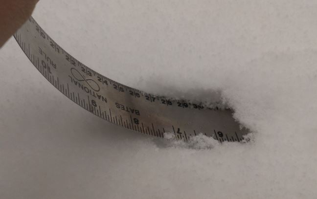
Metal ruler and this technique works best
-
19 degrees and first flakes! Extremely light and you have to concentrate to see them but considering how quick I'll probably flip to sleet, every single flake counts lol. NWS forecast for onset of accum precip is 7pm but anything that falls will stick so hopefully I can get some bonus snow
-
Gefs is building a decent sized camp of near the coast lows. Upper air pattern looks to favor a too far offshore track but this was a pretty good run all things considered. As we just relearned for the millionth time lol.... winter wx tracking is never clear cut and simple even inside of 96 hours. Lead time is double that rn
-
UTC time takes some getting used to but memorize these #s. Daylight savings moves them forward one hour but during winter it looks like this: 0z = 7pm 6z = 1am 12z = 7am 18z = 1pm
-
Jan 24-26 Weekend Snow and Sleetfest Model Thread Part Tres
Bob Chill replied to H2O's topic in Mid Atlantic
Feb 2015 had a west track with a Bermuda high and was all snow lol. 7" in my yard iirc lol. But other than that freakshow, mix lines slow down or stop for nobody when they are in the forecast area -
Jan 24-26 Weekend Snow and Sleetfest Model Thread Part Tres
Bob Chill replied to H2O's topic in Mid Atlantic
It's not that binary. Without blocking a nino will be stuffed with cut and rain events. Ninos are generally much less active so storms are far apart. Miss a few good chances and things don't look good in the end. Ninos aren't created equal. East based are not our friends nor are strong ninos. There's a sweet spot with west based/modiki mod ninos but they come along like 3 times in a person's life. Ninos often run warmish and considering how warm has been working against us, I'm not sold that ninos in the future will be as kind as the past . Time will tell there. The highest probability of snow in the MA is most correlated to the AO and that often works in any enso phase. The AO runs in some sort of longer term cycle that is hard to predict but easy to identify. We just came out of a long term +AO cycle. Seems like the cycle flips in 13 year cycles but thats just an oversimplified #. IMHO, last year and this year indicate that the AO cycle has probably flipped. For that reason alone, I'm pretty optimistic about MA snow chances over the balance of the next decade no matter what enso does. There will certainly be duds but overall I think there will be a string of memorable storms heading our way. -
Jan 24-26 Weekend Snow and Sleetfest Model Thread Part Tres
Bob Chill replied to H2O's topic in Mid Atlantic
Smith Mtn Lake/Penhook -
Jan 24-26 Weekend Snow and Sleetfest Model Thread Part Tres
Bob Chill replied to H2O's topic in Mid Atlantic
Decent virga on radar down this way keeping me entertained for now lol Forecast start time pushed out to 7-8pm so we'll see how that breaks later. Some areas of TN are overperforming in the snow dept so that's a glimmer of hope but I'm not feeling optimistic about 4" of clean snow anymore. Time will tell. Ice amounts have bumped up in my area as well. I'll keep posting until I lose power and internet lol. -
Jan 24-26 Weekend Snow and Sleetfest Model Thread Part Tres
Bob Chill replied to H2O's topic in Mid Atlantic
Lol agreed. Global models aren't supposed to be analyzed at the microscopic level. I never thought the gfs and euro were that apart when people were calling it 2 different planets yesterday lol. This is how it always works entering the short range. Global models will never be identical beyond 48 hours. The gfs and euro ticked towards a middle ground pretty much like they always do. A gfs/euro blend at 72 hours is a pretty safe take with the vast majority of our events. Euro is a superior model in the mid range but the gfs does pretty good with the northern stream. A blend with a hedge towards the euro is pretty much what I do with every storm. Tomorrow the mesos will be more important than the globals. I know you know this stuff and we probably agree that some mountains were made out of mole hills the last 24 hours. -
Jan 24-26 Weekend Snow and Sleetfest Model Thread Part Tres
Bob Chill replied to H2O's topic in Mid Atlantic
My yard will be a good barometer for my northern friends. Time spread for the models with my flip to sleet is as early as 1am or as late as 7am (as it stands right now). Onset right around 6pm or so. Range of snow amounts before the flip is 3-7". If I'm awake lol I'll post my snow totals and flip time. My gut guess is 4-5" of snow, 2-3" of sleet, and .25zr. Anything less than 3" of snow would be a bar buster but 3" or more of sleet would make up for it lol -
CFS weeks 4,5,&6 are normal to AN precip and a -AO, -NAO, -EPO, +PNA combo straight through lol. This -AO cycle looks like it wants to follow the classic 45 day cycle. All this happens during our best snow climo. Feeling very confident more snow events are coming. Not chances... events... heh
-
January 24-26: Miracle or Mirage JV/Banter Thread!
Bob Chill replied to SnowenOutThere's topic in Mid Atlantic
This is a pretty good video tutorial. Since we focus mainly on winter wx, you dont have to master everything. At the very least, memorize levels, temps, and wind direction. All a sounding is is a vertical visualization of the atmosphere from the surface to the jet stream. Winter wx focuses mainly on 500mb or below or roughly 18k' down to the surface. Learn to locate the 0C (freezing line). It runs diagonal and memorize altitude of key levels like 500mb (approx 18k'), 700mb (approx 10k'), and 850mb (approx 5k'). Levels are related to pressure are not static and altitude varies but the approx levels are the most common. Once you get that and the 0C line yaou can track temperature above your head and easily spot the trouble areas and also predict ptype. -
GEFS is picking up on the Miller A idea.
-
Jan 24-26 Weekend Snow and Sleetfest Model Thread Part Tres
Bob Chill replied to H2O's topic in Mid Atlantic
Euro AI a tick colder with a bit more snow down here in the south -
It's obviously long range but analogs and teles are screaming big storm potential. AO on the relax after a big dive and a solid analog list. Weenie rule that the big ones are sniffed out early and a big +WDI