Bob Chill
-
Posts
36,387 -
Joined
Content Type
Profiles
Blogs
Forums
American Weather
Media Demo
Store
Gallery
Everything posted by Bob Chill
-
It's one for the books down here. I'm still at basically 100% coverage. Many side roads are still a packed glacier. Took my dog up smith mtn fire road yesterday and someone had a snowmobile up there within the last couple days lol. 100% coverage for 12 consecutive days has to be a record or close to a record in these parts. My climo kinda sucks (12"+/-) but I'm at 13"+ with 4 legitimate accum events. This winter gets a minimum grade of A- from me. If PD3 pans out or any other decent accum event it would be an A+ based on how I look at this stuff.
-
 As long as I get the most snow for PD3, I hope the dmv gets demolished ...I'll show myself the door now....
 -
Winter wasn't in the dumpster fire category up to that point but watching BOS get 100" of snow in 3 weeks while we missed....every.single.storm... was awful lol. Shortly after Jeb's epic "Scumstonian" rant our fortunes changed. The VD squall was wild. I got 2.6" in 30 minutes then the bottom fell out on temps. I was grilling in the single digits with howling winds after getting squalled. What a great day and beginning of an epic run. I pulled my Rockville yard totals for 14/15. Dec sucked but JFM more than made up for it. 11/26 .8 01/06 3.8 01/21 2.0 01/26 2.3 02/14 2.6 02/16 3.2 02/18 .2 02/21 8.3 02/26 1.8 03/01 .3 03/05 6.8 03/20 1.5 Total: 33.6
-
That guy was hilarious. It was a bit of a punch when he disclosed he was sick and shortly after the blizzard of 2016 he stopped posting. I know I'm not alone when I feel some pain thinking about that stuff. This subforum has been pretty legendary. I will always remember the OGs like Ian, Wes, Matt, etc during events. The clever humor was hilarious at times and the analysis was A+. It was much harder back then before we had 50 models running every 15 mins and model output really needed some skills to interpret. I learned an encyclopedia of stuff basically just hanging out and having fun. I still think this place is incredible for both laughs and knowledge but it's different now. Like everything in life and online , it's always evolving and changing. The stretch from 2006-16 was a class of its own. Eastern was great too but chaotic af during events lol.
- 411 replies
-
- 29
-

-
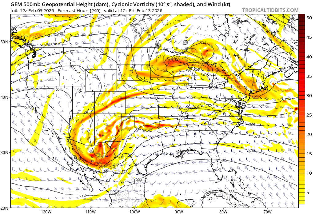
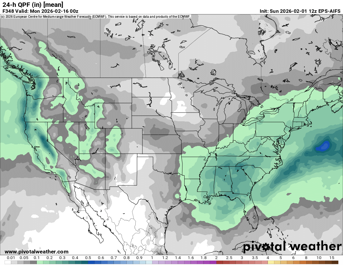
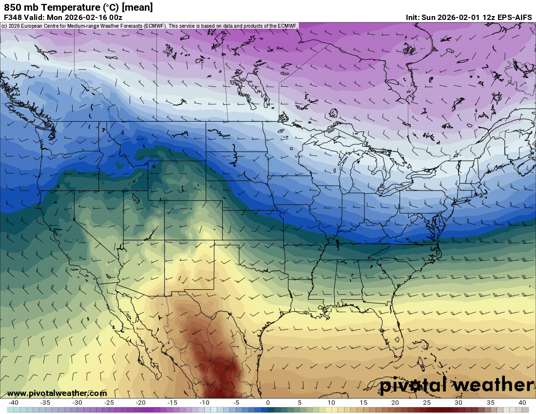
For fun, the cmc is setting up for some kind of winter event in the east during the window...

-
Not that I think the gfs is right during the 14-16 period but it's warm/rainy because the initial wave draws up warmth for the follow up. A more consolidated shortwave timed correctly could work out. Way too far away to worry about fine details in op runs but the window has some things going for it to produce. A warm front/waa snow could do something and a decent track after the cold front could be even better. I'm probably too far south either way but there would be little surprise from me if it becomes a legitimate threat for the dmv. It's a typical luck/timing/chaos marginal setup.
-
My yard is walking the ptype line but your yard is gtg haha


-
It was a fun ride while if lasted. See ya in September when you cancel next winter.
-
Just caught up with this thread. In a nutshell.... lol
-
12/2: T .003" zr and 5-6 sleet pellets 12/5: 3.0 12/8: 3.8 1/25: 4.3 (1.8 snow / 2.5 sleet) 1/31: 2.5 Total: 13.6
-
The Jan 31 Potential: Stormtracker Failure or 'Tracker Trouncing
Bob Chill replied to stormtracker's topic in Mid Atlantic
Models definitely got the crazy gradient idea right. I'm surprised you got less than an inch. I'm prob 30 miles south of you as a crow flies and I'm at 2.5". Still snowing so I may be able to add to that but the end is near. I'm curious what Martinsburg and Chatham end up with. -
The Jan 31 Potential: Stormtracker Failure or 'Tracker Trouncing
Bob Chill replied to stormtracker's topic in Mid Atlantic
It's an evil radar loop. I feel for ya. Been through some incredible busts and march 2013 still haunts me to this day. Looks like the coastal bands are finally going to push into RDU. I hope a deform band sets up and parks over your yard. -
That has to be one of the more evil dry slots. Upper level low and coastal have remained 2 separate and discrete events. RDU should get into the ULL action shortly but it's a shame things didn't merge and play nice today.
-
Richmond Metro/Hampton Roads Area Discussion
Bob Chill replied to RIC Airport's topic in Mid Atlantic
3k and hrrr have done terrible for my yard last 3 runs. I'm over 2" otg and it hasn't stopped snowing since I got up this AM. Had several hours of light/non accum snow between 11am-2pm but it's picked back up the past hour with vis under 1mi. -
The Jan 31 Potential: Stormtracker Failure or 'Tracker Trouncing
Bob Chill replied to stormtracker's topic in Mid Atlantic
Interesting event down here. Figured I was done for the day around 1pm when if looked like dry air was shutting down accum rates. Getting a nice burst of steady light snow and vis back under a mile. Not sure how long it will last but might be able to add to the 2". -
Yea lol. If wouldn't surprise me at all if the ridge connection happens for like... 3 days... before a trough digs right back in. I see nothing about this pattern that says it's going to morph into extended warmth/shutout.
-
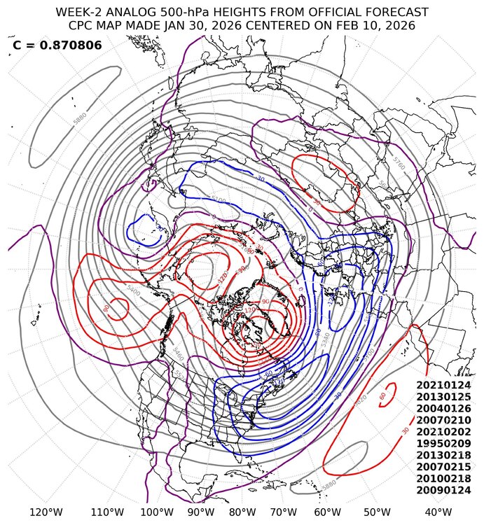
Practically every single one of our snow events has fine details that no hemispheric index can account for. Basically chaos, luck, and timing factors. Those same factors can produce a snow event when basically all indicies are working against us. That said, odds favor higher probabilities of winter weather vs rain when the indicies are in total sync. I personally don't like amplified +pna/-nao periods as much as others here. It's a good combo for a noreaster but it's also a good combo for non-stop cold/dry frontal passages. I personally prefer a more neutral or slightly negative PNA with blocking help because it opens the door for more widespread precipitation across the eastern half of the conus. You've probably heard me talk about the "big bowl" pattern. That's my favorite for tracking because there are multiple ways to score even if the risk is higher for mixed events or cutters. I like action more than big dog chasing and that's why 2013-14 is one of my favorite winters of all time. I have a bias so keep that in mind when I like what I see. A slightly negative pna with a neg ao/nao combo is a big bowl pattern. We might be heading for one and I personally like that even though it opens the door for bad tracks and rain even with blocking. CPC d8-14 analogs are pretty loaded with winter wx chances Late jan/early feb 2021 has a big noreaster but MD didn't do well. Analogs shouldn't be used to predict that level of detail. The fact that a noreaster existed during the analog period is a big plus. We often say "I'd take my chances with a repeat of a storm like that" which is a good way of looking at it. No 2 storms are alike and even though Boxing Day 2010 was a gut punch, I'd take my chances with another shot at a similar but not identical setup. The list above also includes late Jan 04, mid Feb 2007, early Feb 95, and late Jan 2009. All of those periods produced winter wx in the DMV. IIRC, mid Feb 2010 also had a big coastal that impacted areas to our NE. The above list is yelling that a potential east coast storm is on the horizon
-
Big blocks (especially the NAO) have a history of this. Some of the dmv's coldest/driest periods have happened during strong neg naos. Carolinas biggest storms have occurred during the same. The flip side is some of the biggest dmv storms have happened during the breakdown of big blocks. Based on history, were prob not even at the halfway point of the current blocking cycle and it will oscillate. The next 3-4 weeks are also the dmv's prime snow climo. I'm pretty optimistic for snow chances over the next month and (imho) chances for a large storm are above to much above normal.
-
Fwiw, ukie was abysmal with the current storm. I mean absolutely terrible. Euro/ai appear to be doing the best (shocker lol), cmc #2, gfs/ai #3. Imho, based on what I've seen so far this season, you can pretty much hug the euro/ai combo inside of 7 days and use the cmc for confirmation. Gfs seems to only add uncertainty into the mix
-
The Jan 31 Potential: Stormtracker Failure or 'Tracker Trouncing
Bob Chill replied to stormtracker's topic in Mid Atlantic
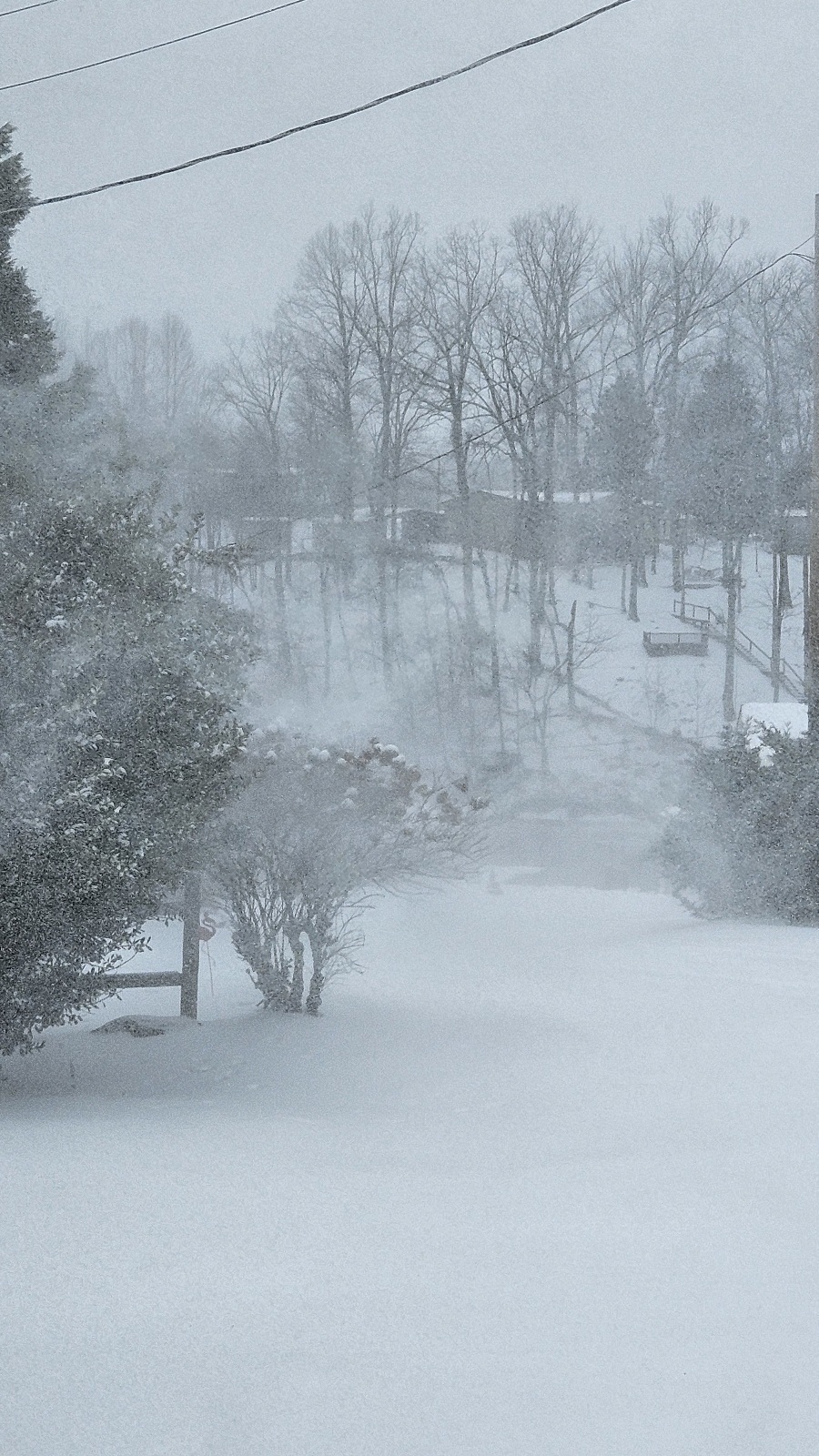
Up to 2 inches so far. Looks like most models are going to bust low on the NW periphery. Not sure if I can squeak another inch out but the mesos aren't going to do well with this one in my yard. 15 degrees and the wind is picking up. Roads dont look like roads lol. Snowmobiling isnt a thing down here but I sure wish I had one today lol. Deep winter.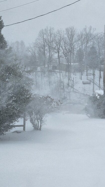
-
Richmond Metro/Hampton Roads Area Discussion
Bob Chill replied to RIC Airport's topic in Mid Atlantic
I'm just a few miles from the dam at Smitn Mtn Lake -
Richmond Metro/Hampton Roads Area Discussion
Bob Chill replied to RIC Airport's topic in Mid Atlantic
All guidance has bumped south with qpf (in their own way) but I've already picked up an inch and it's steady light with bursts of mod high ratio snow. This is a tricky storm with 2 distinct areas of synoptics and dry air entrainment in between and around the periphery but so far in my yard guidance is busting too low. I hope that translates eastward into your yards. -
The Jan 31 Potential: Stormtracker Failure or 'Tracker Trouncing
Bob Chill replied to stormtracker's topic in Mid Atlantic
Getting kinda lucky I think. Picked up up an inch overnight/early AM and steady light high ratio snow. 16 degrees. -
Richmond Metro/Hampton Roads Area Discussion
Bob Chill replied to RIC Airport's topic in Mid Atlantic
It's been snowing lightly for the last 30 mins and had flurries earlier today around 10-11am. Not much virga. When radar shows 10dbz or higher its making it to the ground. -
Richmond Metro/Hampton Roads Area Discussion
Bob Chill replied to RIC Airport's topic in Mid Atlantic
My yard has been riding the line between 3-6 and 1-2 and I've pretty much been expecting 2-3" tops but being so close to whiter pastures keeps me interested in the idea of a more impactful event. The 12z euro ai/euro/gfs all bumped better qpf northward. Not a ton but all 3 did and it's encouraging. If 18z does the same I'll be more confident in the 3-6 idea. Ratios will be high no matter what. Blacksburg's AFD stated 15-20:1 rations and I believe it. Upper level lows are often fluff bombs and it's plenty cold. I could potentially get close to 6" on .30qpf. RIC could get 4" on .20. Time will tell. Keep expectations low and enjoy the F out of a boom if it happens