Bob Chill
-
Posts
36,386 -
Joined
Content Type
Profiles
Blogs
Forums
American Weather
Media Demo
Store
Gallery
Everything posted by Bob Chill
-
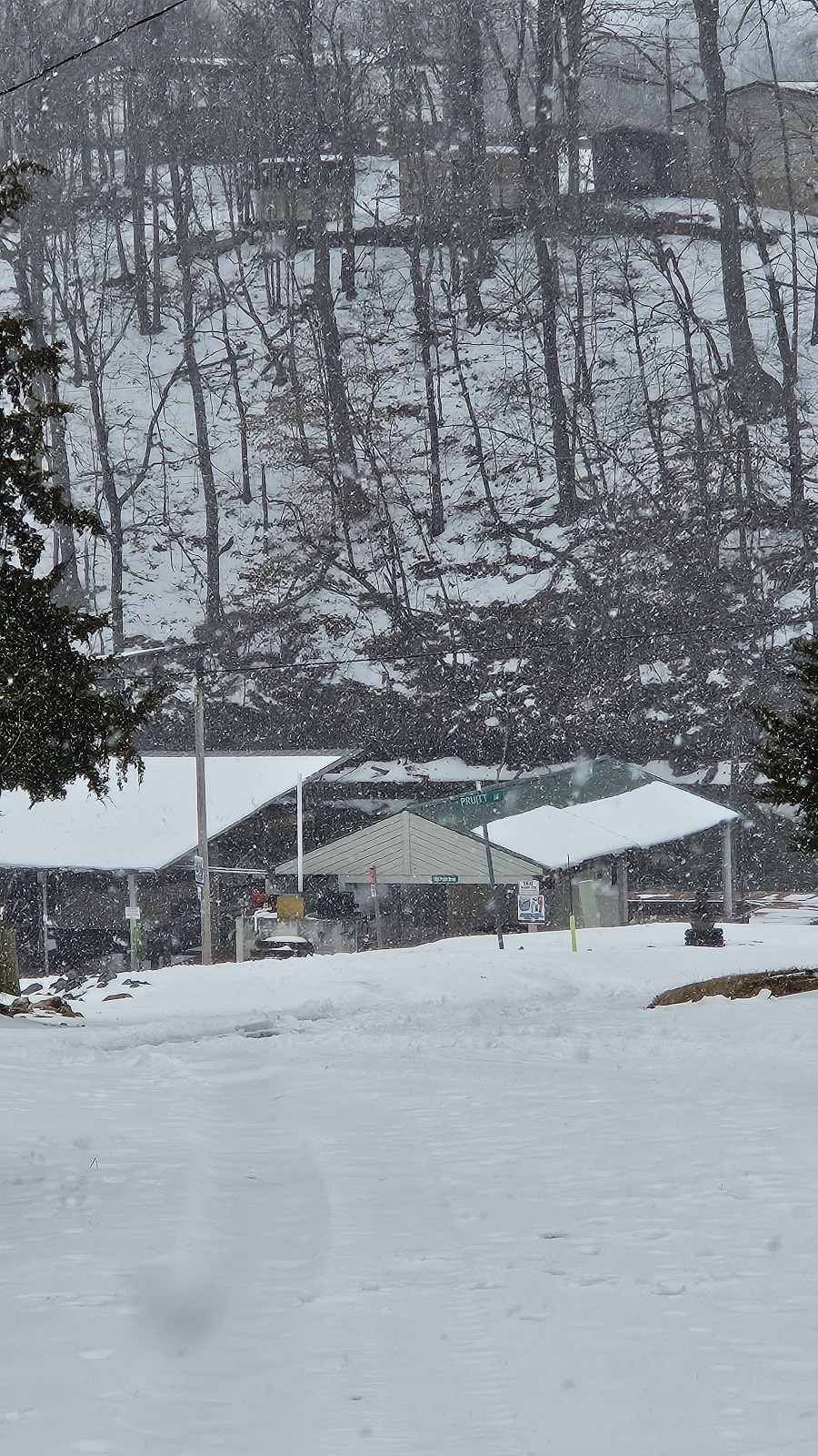
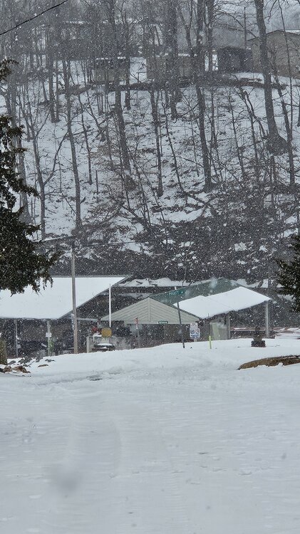
Mod snow/sub 1mi vis. Starting to stick a little. Honestly didn't see this coming. Was certain it wouldnt work down here. Hope this slug translates to the DMV. Was covered in sweat and dirt 24 hours ago. Wx is awesome lol
-
Slush missiles have commenced. I didn't believe the models showing snow this far south but hey, I'll take the win.
-
Thundersleet lol. What a wild day
-
Should have waited 60 seconds before I posted... sleet now lol
-
Still rain here but had a heavy roll thru and it frosted the pines at the top of smith mountain. I'm at 900' and top of smith is 2k'. Not sure if snow will make it this far down but it's pretty close....
-

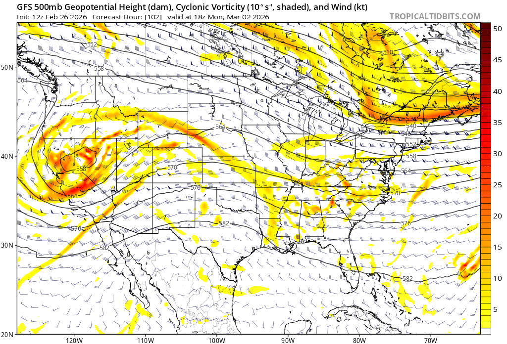
Outta gas and Outta Time: Early March Winter Storm finale
Bob Chill replied to Ji's topic in Mid Atlantic
There's been some poor post quality this year. You know this up down but mid/late March snow can 100% happen all the way to the coast. Even in RIC (3/12/2022). It's not common because it requires some specific longwave features to overcome climo. A legit-AO and/or -EPO can 100% deliver an airmass capable of producing. They don't last as long as earlier in the season so windows of op are shorter but a warning level snow is in the deck for all of us.- 959 replies
-
- 14
-

-

-

-
Outta gas and Outta Time: Early March Winter Storm finale
Bob Chill replied to Ji's topic in Mid Atlantic
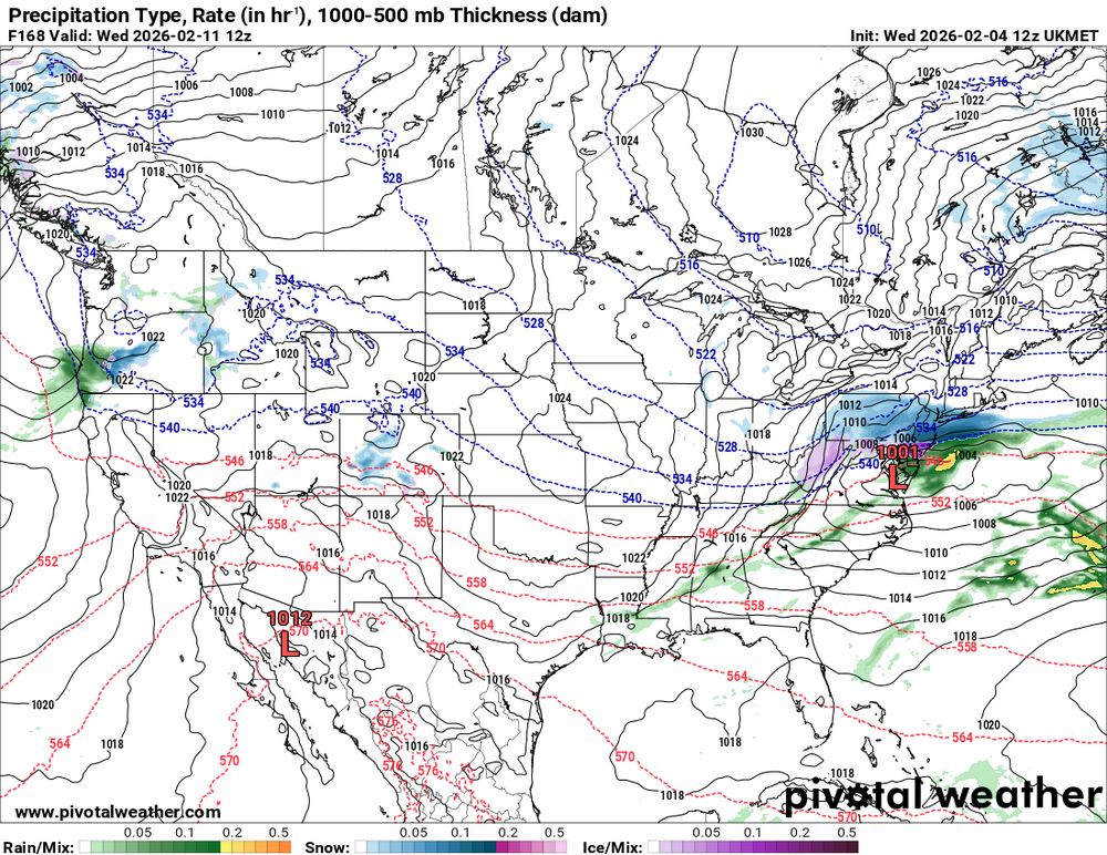
Upper levels have looked pretty blah on this one since the beginning. I agree with Wes about the overcooked potential and that's why I've been quiet. It's just not adding up for a 6" snowfall anywhere. Weak sauce won't do it with surface temps so I've been leaning towards SnowTV at best and I also don't think it ends up hitting my yard. Central VA thru the DMV is the most likely area to see any snow falling. If I only saw this panel on the GFS I would never think a 6" snowfall would be the outcome. I would think a swath of scattered light precip and not a shield that drops .5+qpf. All that said, models haven't locked into the strength of the shortwave and it definitely bears watching for accum snow for someone. The setup with the HP pressing into the precip is much better than HP running away. With enough lift pushing against a modest shortwave it can maximize potential in narrow stripe.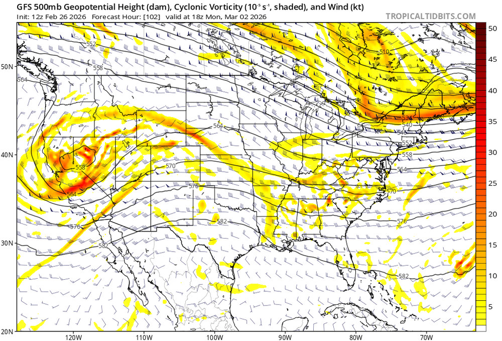
-
Outta gas and Outta Time: Early March Winter Storm finale
Bob Chill replied to Ji's topic in Mid Atlantic
Thank you for the intro good sir. With great honor I accept my 6" of digital snow and bare ground award on Monday. -
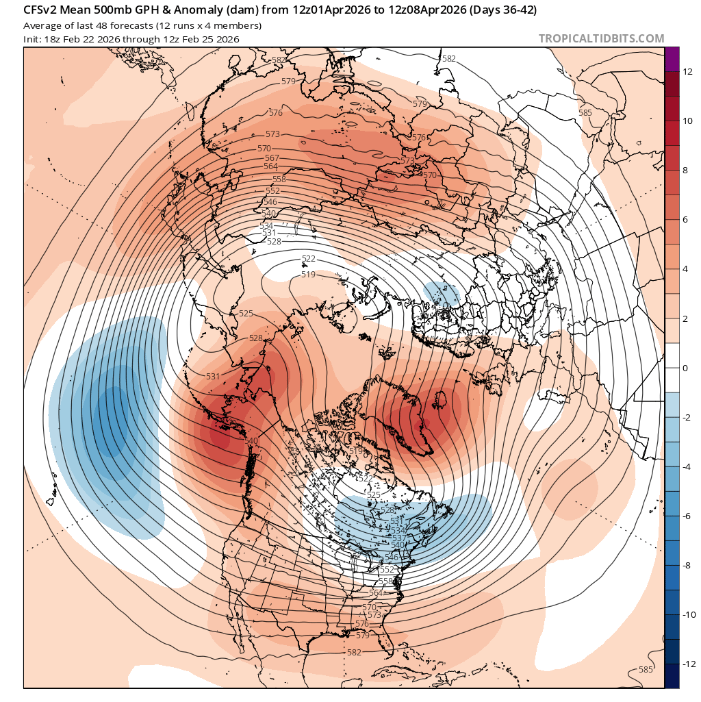
First week of April looks money
-
Outta gas and Outta Time: Early March Winter Storm finale
Bob Chill replied to Ji's topic in Mid Atlantic
This may be the most ridiculous thread of the year. Euro AI hits me pretty good. I'm in. -
Feb 22nd/23rd "There's no way..." Obs Thread
Bob Chill replied to Maestrobjwa's topic in Mid Atlantic
It's been pretty rowdy down here too. Went outside to work for a bit, got blasted by a 2 minute gust, couple branches fell near me, went right back inside. Not enough wind to damage much but plenty of 40mph gusts today. Not a good boating day on the lake I don't think -
Feb 22nd/23rd "There's no way..." Obs Thread
Bob Chill replied to Maestrobjwa's topic in Mid Atlantic
Under an advisory down here but of the wind variety. It's howling with some random flurries so at least I got some snow. Rain performed well. It poured last night lol. The Miller a/b debate has been going on since I joined Eastern in 06. The truth is that true/clean Miller As and Bs are more rare than something in between. The majority of our coastals are hybrids and have parts of both. Imo, the current storm is not a Miller B screw job at all. There was a solid period of WAA precip AND half decent backside precip. Those are pretty good to the DMV. Screw jobs are either late developers with no WAA precip or having the WAA die off and lull during the transfer then everything after is too late for the MA latitude. The current storm is what you want with a hybrid but the front side was wasted because of temps. That's just the way it goes sometimes. It will happen again -
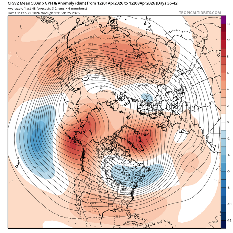
March 2007 (both events) and March 2022 analogs are on the list right now. Pattern seems pretty favorable for the MA considering it's getting pretty late in the season. I'm probably too far south but imo, the DMV probably has another chance or 2 before time runs out. It hasn't been a super productive year but interesting winter wx has been on the table since the start and this season is from from a dud/ratter. The amount of snowcover days down here probably falls in the top 10% of recent history.
-
Feb 22nd/23rd "There's no way..." Obs Thread
Bob Chill replied to Maestrobjwa's topic in Mid Atlantic
I hope the old school MoCo/HoCo band sets up and dumps white asteroids for hours hahaha. Unfortunately I've had to root against this one down here and was never in the game anyway so it was easy. The 3 week glacier really set me back with property development work and I'm behind schedule. Picked up 2 nice excavator jobs for the second half of March so I'm seven days a week on our land until then. Had a real good winter down here this year. I gotta root for warm and dry from here on out so I'll only jump back into wx disco if I'm in legit crosshairs for a late season event. Always pulling for my northern friends. Enjoy the storm! -
Low vis mod rain all morning. Just a wonderful cold rain piling up in ditches, potholes, and mud depressions. Y'all jelly don't lie now. Planning doing a jebdrive to knock off a few layers of dirt salt here shortly. I'll take pics
-
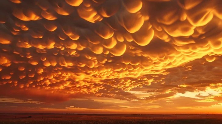
Mammatus cloud sunset. Rare but they happen in the dmv once in a while. Mammatus clouds behind a gnarly thunderstorm are wild but toss a sunset color pallet into it and it's other worldly. Not my pic but what a show here...
- 19 replies
-
- 11
-
-
Idk. Been a snow magnet this year. Radar looks half decent for continued showers/squalls but highly doubt it will amount to much.
-
Dumping down here. Legit mod+ snow lol. Roads caved!... or haven't been plowed in 2 weeks.... one or the other.
- 553 replies
-
- 25
-
-
Ended up with a clean half inch last night.
-
Official car topper now and temp down to 32. Might pull off something, measurable if another pulse comes through.
-
Snowing lightly down here. Started around sunset with snow pellets. Slowly transitioning to dendrites. I'm at 33 degrees so it prob won't accumulate unless it picks up quite a bit. Euro says I get 1-2" lol but I think those odds are 1-2% lol
-
Ukie says don't even write off the pre-PD3 event lol Models breaking persistence too quickly has been a thing for as long as I've played this game. In both directions many times. Since most of our winters kinda stink it feels like that only works against us but persistence is a real thing and toning down warmth in the LR has been happening since early fall lol. It doesn't surprise me at all that guidance has been easing off the warmth part of the pattern. Remember JFM 2014? Day 15 warmth was a staple in guidance. Remember how it went lol? We need a pattern change or it will just keep being dry and cold. Looks pretty locked in that flow will be MUCH more active than its been for many weeks. Back off on the warmth and keep sending shortwaves our way every 3-4 days and we're bound to chaos/luck into something.
-
It's one for the books down here. I'm still at basically 100% coverage. Many side roads are still a packed glacier. Took my dog up smith mtn fire road yesterday and someone had a snowmobile up there within the last couple days lol. 100% coverage for 12 consecutive days has to be a record or close to a record in these parts. My climo kinda sucks (12"+/-) but I'm at 13"+ with 4 legitimate accum events. This winter gets a minimum grade of A- from me. If PD3 pans out or any other decent accum event it would be an A+ based on how I look at this stuff.