
Bob Chill
-
Posts
36,385 -
Joined
Content Type
Profiles
Blogs
Forums
American Weather
Media Demo
Store
Gallery
Everything posted by Bob Chill
-
Exactly. The PDO is just a single piece. Just dont want a big -pdo flex. That really hurts. Doesn't look like that is happening... so far.... I wouldn't be surprised if your area is one of the weird jacks this year. Recent history is on your side. I dont expect anything exceptional in my new yard no matter what happens this year lol
-
Nina climo can be harsh with the MA getting a major or historic storm to run the full gauntlet but it's always possible for an average coastal to make a run up 95 in any enso state. Nina's favor higher totals north of us but it's not a stretch at all to get a 6-10 swipe here with double that from Philly north. Get some legit blocking in place and bigger things can happen like Jan 96 and 11. Far fewer and between for big storms but no sense ruling them out until March
-
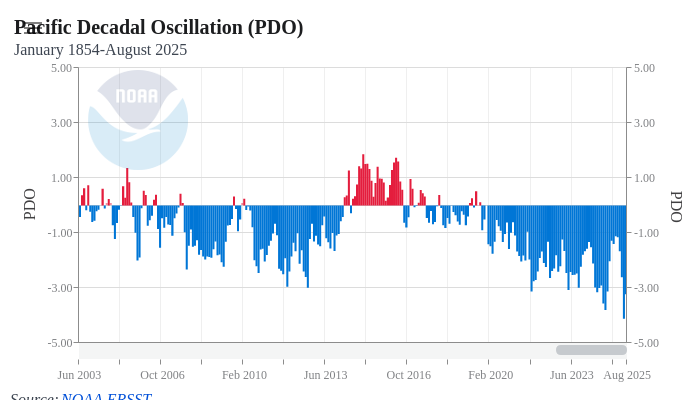
I've become more optimistic for a couple basic reasons. The Wpac/pdo area has improved dramatically in just a month and a half. The nina setup isn't that strong and may not drive the bus in a bad way (SE ridge of doom and stuff like that). Lastly, my personal algorithm and gut instinct likes the chances of a favorable AO/NAO on the balance for DJFM. I'm pretty confident in some decent blocking at times and it probably will include Dec. If/when/how much is way beyond my pay grade. But the Dec AO monthly mean is probably the most reliable long range index there is. Get a Dec AO avg below -1.25 and a dud winter is most likely off the table. PDO is still negative but considering the frog boil that was happening back in early Sept, things have greatly improved. Maybe due to the record cold in Siberia exiting the coast. Not really sure. But this plot doesn't look dire to me anymore. All this said, I'm kinda meh on snowfall totals. My wag is sub climo and that's a pretty easy guess all things considered. Getting a northern stream dominated winter to produce consistently is awful tuff in these parts. Would need some sort of stream phasing at times or a really big block to bring the goods. Both of which are possible... but probable?.... nah lol Gun to head, temps within 2 degrees of avg either way and somewhere around 75% of climo snow with some random iteration of weird jack zones vs typical embedded in the mix. It's still pretty early to marry any ideas. Once Dec comes into focus we can start hallucinating victory or hitting the panic button with more confidence. ETA: the WDI is pretty strong for at least one traditional good coastal storm that puts down a large blanket of warning totals through the MA and NE. We really are due for something like that.
- 827 replies
-
- 12
-

-
With the 660hr cfs having the same accuracy as 360hr gfs, seems reasonable. Maybe we should be conservative and wait until it's under 500hrs on the cfs and the 384hr gfs extrapolates properly.
-
I mean if you're good with a 6" paste job in mid Nov then fine. I'm bored of them. Need something anomalous to get my attention. Just few a few years ago in 87 we had a good one though
-
Idk if it matters either way. We get storms like this all the time in mid Novie and they melt too quick. Boring
-
Headin back to Penhook tomorrow. Fall colors made a nice shift since we got here. Snapped this a few hours ago. Should be one of the better color years this year
- 427 replies
-
- 17
-
-
I was kinda surprised looking at the plot. I made a mental note several weeks back that ensembles showed persistent troughing in the Wpac but never remembered to track progress. We'll see how it looks in another month when it really starts to count. At least it looks good enough to hallucinate a path to victory now. Weak nina with a -epo and some -ao/Nao thrown into the mix and we can start throwing around the 13-14 and 14-15 analogs hahahah
-
Marked improvement in the PDO region over the last 30 days. Only around halfway to neutral though lol but you gotta start somewhere
-
Staying with the wife out near Luray for the homesteaders conference in Front Royal. Rented a mountaintop cabin with a crazy good view. Freeze warning last night but didn't really get close. 37 when I woke up around sunrise. Sunrise and sunset view of the Blue Ridge from the deck today. Fall colors are just getting started. Some nice patches of maples but green is still dominant.
- 427 replies
-
- 16
-
-
As usual we're aligned with our logic... which may not be a good thing this year... hahaha. Imho, if this winter is going to be friendly we probably need a good start in Dec and that's certainly possible in a nina. If Dec is a warm whiff I kinda doubt a backloaded comeback. I'm rooting for big snow/cold out west in Nov. When I lived in CO, nina hot starts usually had some sustained +PNA stuff in Dec. Which was frustrating then but perspective and things. I'll be using the Jackson Hole indicator in Nov. If they're getting dumped on mid/late Nov, we'll have some chances here in Dec.
-
Being honest, I'm feeling underwhelmed with my prelim thoughts. So far everything has the feel of a slow start, couple brief but potentially exciting periods Jan/Feb, and lots of boring stuff in between. The flavors of 05-06 and 08-09 come to mind but I'm just guessing. One thing that's nearly certain is some sort of "unexpected persistence" will happen with little lead time or analysis. That kind or stuff is what keeps me out of making any kind of definitive calls from way out in time. No matter how much early season analysis is done, a piece of winter personality bucks consensus/traditional thinking. What that will be this year (if at all) is anyone's guess. My optimistic side says the AO/NAO will play nice more often than being hostile. Especially the NAO. A legit blocky winter can offset a lot of nina crappiness. I sure don't like look of Pac SSTAs so far but that's just one piece of the puzzle
- 827 replies
-
- 10
-
-

-
Did you guys up north of me notice a massive drop-off in ticks during the dry spell? There were armies of ticks everywhere during the 2 months of Florida soup and over the last 4-6 weeks it's almost like they disappeared. Haven't seen a single one on our dog in a month after being a tick magnet for the 2 previous. We treat him but the ticks still get all over him before dying. Not a single one in weeks seems really odd. Of course I hope every tick on the planet dies yesterday but this cycle seems weird
-
Right where we want it at this range and winter stuff like that
-
After nearly 6 weeks of nothing... picked up just under an inch in the past 24 hours. Feast or famine has been the theme for the last couple years. Prolonged dry is followed by too much lol. I doubt the 0z euro for down here (10 inches over 6 days lol) but i have a hunch my area will get peppered pretty good. Dust bowl to mud bowl in a blink lol
-
Fall color starting to pop at the top of Smith Mtn (about 2k'). Maple, elm, and hickory mostly. Oaks still mostly green but the acorns are carpet bombing everything lol. Lots of pines on the mtn so it looks really nice during peak with the contrast.
- 706 replies
-
- 28
-
-
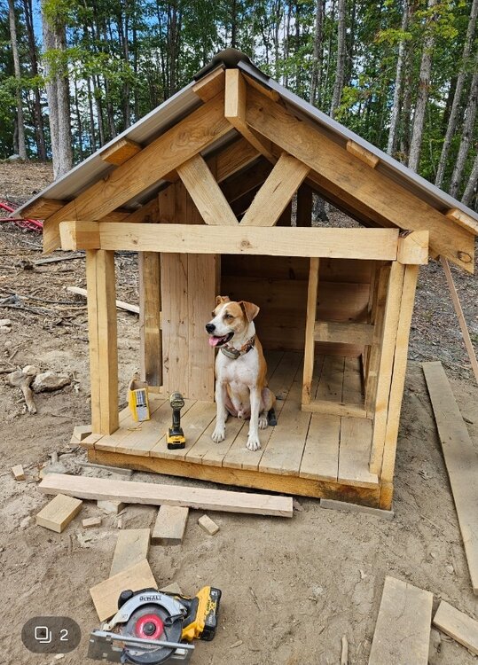
Wife and I were joking that our dog got a new house on our land way before us lol. So why not... auto water and maybe a pinball machine and mini fridge.
-
We kicked around the chicken/egg debate quite a bit that year. Looking back at historical data it looks (to me) that the initial warm pool was the direct result of a persistent anomalous pattern causing the PDO to spike and then some sort of feedback. SSTA plots through the fall of 2013 don't look like a harbinger to me. The NE pac was loaded with BN temps in early October but then flipped over the next month into Nov. But the PDO was spiking during that time which makes sense. Persistent troughing near Japan would naturally have a downstream ridge. Then in Dec the -epo kinda shoved the warm pool further east into the GOA region. When I look at this stuff from a 10k' view, the +PDO was the catalyst for the SSTA configuration leading to the "warm blob". The blob got bullied and enhanced by a anomalous -epo pattern that kept reloading. We've discussed this before but worthing pointing out again.... the NE pac has a cold current and is never "warm". So 5 degrees above normal is still pretty cool. Hard to say how much influence that area of the Pacific can have on the upper levels of the atmosphere. Imho, the upper levels drive the bus and not the other way around in this specific region. But having the type of ssta configuration we has in 2013-14 was most definitely an important clue or guage of what was going on in the atmosphere. If this winter isn't going to be a dud, the crazy -PDO has to implode at some point leading into met winter. You've pointed this out already but if the PDO is roasting when we're eating turkey and watching NFL games... I won't be very optimistic
-
We already discussed a solar fan. He's a great dog and worth it
-
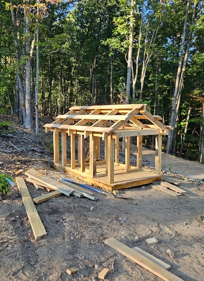
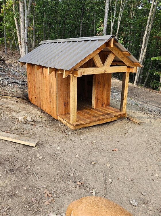
Just finished a really fun/satisfying build on our land. We ended up with 2 wells drilled because the first one had a silt problem and the driller guaranteed a good well. We're using the problem well for irrigation so it's an amazing bonus resource but you can't have 2 well heads on a single permit and permits are expensive. Driller told us to camouflage the problem well. Since it sits at the junction of our main drive and homesite driveway, inspectors will literally drive right past it every time they come. Wife came up with the idea of putting a doghouse there and hiding the well head behind a fake wall inside. Thought it was brilliant so I went to work. I've been milling logs from the land clearing project back in the spring so I have a small mountain of lumber to work with lol. House is framed with yellow and red pine and decked/sided with white oak. Turned out really slick and I'm pretty proud of this build. Adds a really nice touch to the property and most importantly... the dog loves it lol
- 267 replies
-
- 15
-
-
Total ripoff here too lol. Just enough to make the dust damp. Not nearly enough to do any good. It's pretty comical driving the gravel roads. Mile long smoke screens make me laugh . Reminds me of the old video game Spy Hunter
-
Been seeing them a lot this year. Prob once a week. My son hit (and killed unfortunately) a young male driving back in July. I think the population must be up because there are reports of them getting into trash in more developed areas around smith mtn lake as well. There's a ton of undisturbed forest around here so frequent sightings must be part of a population increase. Deer have definitely boomed and a few too many coyotes are running around. Coyotes are the only animals that I wish weren't around. They will kill dogs and our dog will chase anything lol. Bears stay clear of dogs
-
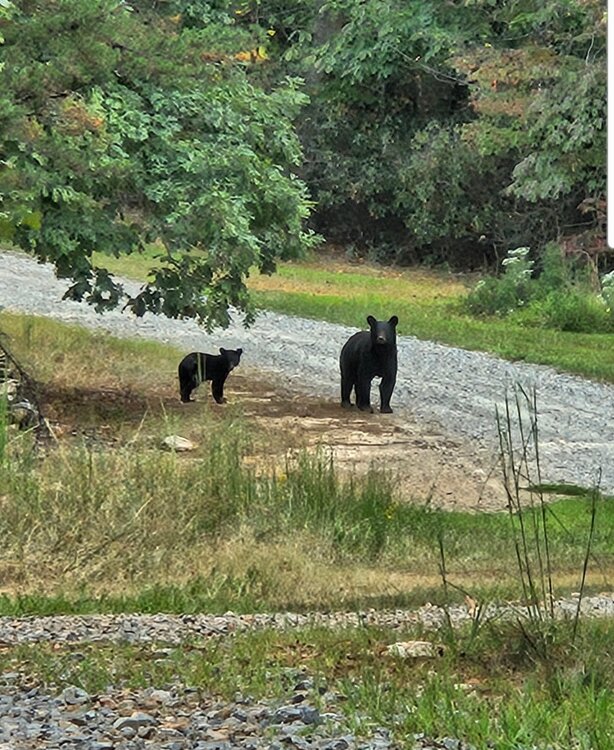
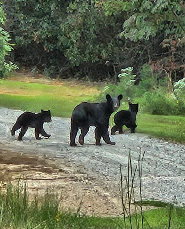
Great outdoor work wx but it's a dry dust bowl lol. Ran into a mom and some cubs today. There were 3 cubs but could only get 2 in a pic. I was about 100yds away. Black bears around here are curious but keep their distance... thankfully... lol
- 706 replies
-
- 20
-
-

-
The NE pac warm pool didn't get going until Dec and the PDO was favorable at the beginning of met winter. The persistent epo pattern caused the warm pool to form and then there was a feedback loop of sorts that persisted well into March. Imo, it's a stretch to be using current ssta conditions in the Pac and pulling out the 13-14 analog.
-
This is a good visual showing just how hostile the pdo has been since 2017. It's only one piece of the puzzle and no single index drives "it all" but it's also no coincidence that the last time it was friendly (2014-16) we had one of our best stretches of consecutive winters. In enso neutral and nina winters we need a good alignment in the Pac or it gets pretty hard to get things right around here with cold and winter wx. If things are going to work this winter a -EPO will be really important. Generally speaking, -EPOs don't come easy if at all when the PDO is strongly negative.
- 827 replies
-
- 10
-

-


