-
Posts
4,691 -
Joined
-
Last visited
Content Type
Profiles
Blogs
Forums
American Weather
Media Demo
Store
Gallery
Everything posted by Stormchaserchuck1
-

El Nino 2023-2024
Stormchaserchuck1 replied to George001's topic in Weather Forecasting and Discussion
Looks like some unfavorable phases coming up https://www.cpc.ncep.noaa.gov/products/precip/CWlink/MJO/CLIVAR/clivar_wh.shtml -

El Nino 2023-2024
Stormchaserchuck1 replied to George001's topic in Weather Forecasting and Discussion
-NAO's have certainly been harder to stick lately, for the last few decades. -
The neg NAO starts with -PNA. https://ibb.co/HP6Kzqx PNA never really goes positive through current 15-day models, so let's see if it trends (El Nino)..
-
I think we may have a -PNA this February. The 6-year running mean is +150dm over the PNA region.
-
Hopefully we have a +PNA by then. That is some interesting energy moving across the US around Dec 4-6 though.
- 1,295 replies
-
- wishcasting
- almost winter
-
(and 1 more)
Tagged with:
-

El Nino 2023-2024
Stormchaserchuck1 replied to George001's topic in Weather Forecasting and Discussion
In a lot of cases, it has been just as strong as the warmth is in the eastern subsurface. Some years like 1972 had mostly negative subsurface waters, while the surface was Strong Nino. 0-300m, yes. -

El Nino 2023-2024
Stormchaserchuck1 replied to George001's topic in Weather Forecasting and Discussion
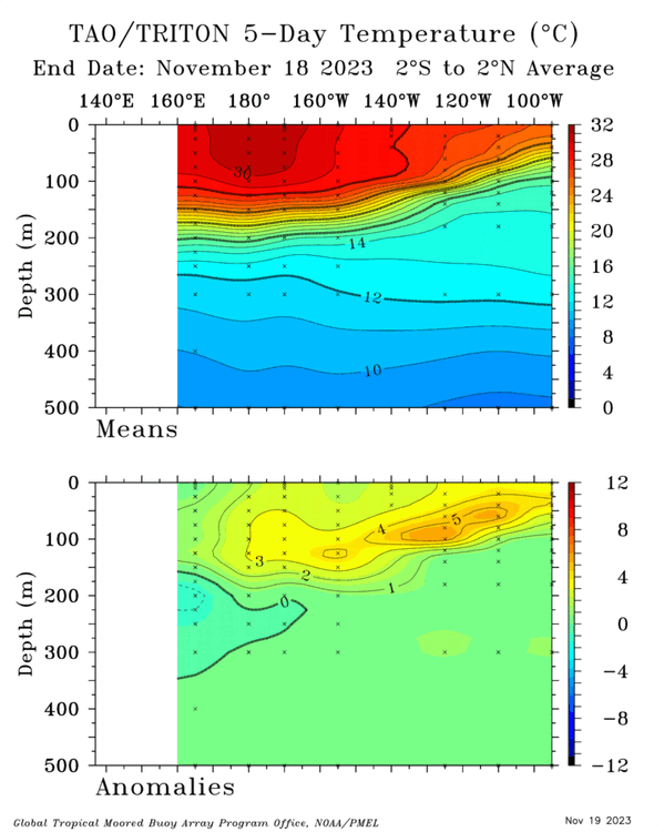
Subsurface is really heating up. +5c over a large area according to the TAO/Triton maps, which is by far the greatest of the event so far. https://ibb.co/jyXz36R And again, we aren't seeing cold water in the western subsurface, like other Strong events at this time of year. That could negate the tendency for us to automatically flip ENSO states next year. -
I've been saying watch near Dec 5th for our first possible snow event. This isn't a strong signal, but it's not that far off a really good setup.. https://ibb.co/vdN2TYW The reason is a stronger piece of energy is dropping into the SW around Dec 1-3.. when that moves east if we have this 3-wave setup with nothing else, like a Aleutian High, then we might have a snow event to track. El Nino should keep us away from -PNA as this trends closer, but let's see..
- 1,295 replies
-
- 3
-

-
- wishcasting
- almost winter
-
(and 1 more)
Tagged with:
-

El Nino 2023-2024
Stormchaserchuck1 replied to George001's topic in Weather Forecasting and Discussion
I don't think the -PDO is really a good reason either: Air dominates water. -

El Nino 2023-2024
Stormchaserchuck1 replied to George001's topic in Weather Forecasting and Discussion
Maybe the El Nino is why models are fluctuating so much? I noticed a much greater than average change in the MR/LR models for the first time when the El Nino started up in the Spring, through the Summer, and now with a major model shift in the last few days (now -NAO and +EPO), this is when El Nino is spiking.. it seems like it would be an independent thing, the model flux, but maybe it's related to the El Nino? -
Since 2019, almost every single -NAO has correlated with a +EPO/-PNA, and +NAO's correlating with -EPO/+PNA.. that really holds true in these recent shifts. I think something is happening globally that makes it all run together. I would of course, rather see the +PNA/-EPO/+NAO combo and we can get a Winter like 14-15.
- 1,295 replies
-
- 1
-

-
- wishcasting
- almost winter
-
(and 1 more)
Tagged with:
-
I think our first flakes are going to wait until that Pacific pattern breaks down. +EPO is the worst pattern for snow, -PNA the second, and models went big in that direction today. But like I said last night, they are fluctuating big time day-to-day. They had a +NAO in the MR/LR a few days ago which is now a big -NAO. Back to the basics: We have a > +2.0 Nino 3.4 strengthening El Nino happening, so we should favor more +PNA or GOA lows, let's see if models drop the big -PNA/+EPO that they, today, have, if nothing else just because of ENSO.
- 1,295 replies
-
- 2
-

-
- wishcasting
- almost winter
-
(and 1 more)
Tagged with:
-
How about these run to run model changes? Now we have a -PNA and -NAO??
- 1,295 replies
-
- 2
-

-

-
- wishcasting
- almost winter
-
(and 1 more)
Tagged with:
-
Moderating under +AO.. will probably veer warm, but this is an interesting setup with developing 50/50 low and GOA low. We don't miss it by a lot. I expect to see a lot of this setup in the Winter (+nao/good Pacific at the same time).
- 1,295 replies
-
- wishcasting
- almost winter
-
(and 1 more)
Tagged with:
-
We tend to be a little drier in Nov and Dec
- 1,295 replies
-
- wishcasting
- almost winter
-
(and 1 more)
Tagged with:
-
Really getting cold after this Wave #3. https://mag.ncep.noaa.gov/data/gfs/18/namer/10m_wnd_2m_temp/gfs_namer_237_10m_wnd_2m_temp.gif Colder than 12z run
- 1,295 replies
-
- 1
-

-
- wishcasting
- almost winter
-
(and 1 more)
Tagged with:
-

El Nino 2023-2024
Stormchaserchuck1 replied to George001's topic in Weather Forecasting and Discussion
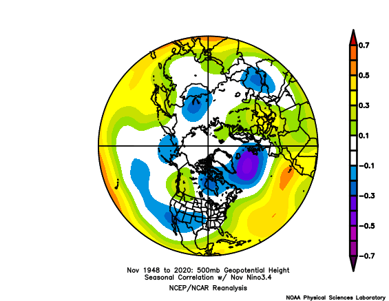
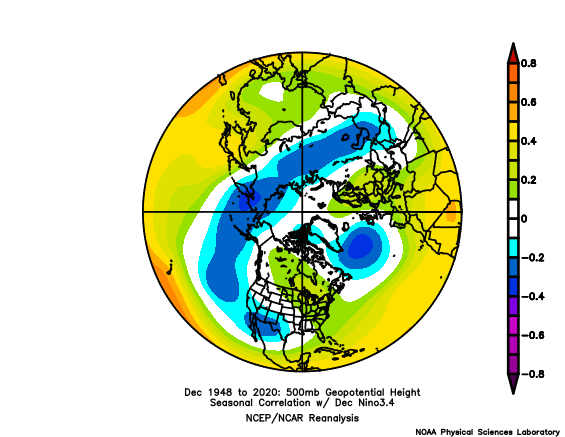
I think I posted before that Nov has historically low correlation between ENSO and the N. Pacific pattern, that it starts picking up +correlation in the month of December With the subsurface on fire, it's no surprise to see this strong N. Pacific low signal on the LR GEFS https://ibb.co/xj57pjJ as December starts correlating better in the N. Pacific -
The El Nino is really spiking up right now, both on the surface and in the subsurface, passing +2.0 in Nino 3.4. LR GEFS shows a healthy N. Pacific low: https://ibb.co/xj57pjJ But it also has some ridging in the NE from +NAO, that will need to be sorted out in future model runs (NAO region has been volatile at that range).
- 1,295 replies
-
- wishcasting
- almost winter
-
(and 1 more)
Tagged with:
-

El Nino 2023-2024
Stormchaserchuck1 replied to George001's topic in Weather Forecasting and Discussion
https://www.pmel.noaa.gov/gtmba/pmel-theme/pacific-ocean-tao You can click on "Data", then "Data Display" then "Assorted Plots" -
The ridge gets stuck in the GOA, instead of the WC. Looking at the NAO, AO, and EPO I would guess we have more of a chance at snow.. Canadian low keeps us warm.
- 1,295 replies
-
- wishcasting
- almost winter
-
(and 1 more)
Tagged with:
-

El Nino 2023-2024
Stormchaserchuck1 replied to George001's topic in Weather Forecasting and Discussion
I don't know.. one storm cut up into the SE in 2009, and one storm didn't this year? I think the pattern is above average precip right now generally.. this goes back to when -NAO's were active last Dec and March (anomaly). -

El Nino 2023-2024
Stormchaserchuck1 replied to George001's topic in Weather Forecasting and Discussion
-
We are always blessed to have the Ravens to watch.. 25 years of good interesting football. League is kind of weak this year. I'm always surprised that Lamar Jackson is underrated.. preseason 1/20 odds to win the SB, now 1/10 I still think is low, they are probably 1-3/4, maybe higher than that even with Andrews hurt.
-
There is a warm pocket by the dateline that in relative terms is greater than the eastern regions anomaly right now.
-
El Nino is rapidly shifting to west-based, and there are no negative anomalies below the western ENSO region. December is the 1st month where there are strong correlated effects in the N. Pacific from the NPH to PNA... we should be golden for a mostly +PNA Winter I think.. The subsurface is different from "Strong Nino's" that had cold water in the western subsurface.


