

78Blizzard
-
Posts
3,693 -
Joined
-
Last visited
Content Type
Profiles
Blogs
Forums
American Weather
Media Demo
Store
Gallery
Posts posted by 78Blizzard
-
-
18z GFS says cold and dry here for next 10 days, with below 40°F temps throughout until the end of the period. zzzzzzzzzzzzzzzzzzzzz
-
2 minutes ago, USCAPEWEATHERAF said:
You are talking about the possibility that an Operational GFS run of the 18z hour being correct for 16 days, come on.
"if the GFS verifies".
-
These next 16 days will be very forgettable if the 18z GFS verifies. A little over 0.5" qpf, 90% of which falls on Sunday, and after Monday near normal temps for my hood during the period. Will finish the leaf harvesting tomorrow.
-
 1
1
-
-
42 minutes ago, ORH_wxman said:
GFS looked a lot healthier for 12/5 threat tonight...close miss. Still time to breath life back into that one.
The circuit is now complete as the IKON finally gave up and went OTS, lol.
-
1 hour ago, Typhoon Tip said:
Just throwin' 'nother solution into the fray... the always correct with no cause for doubt 'ICON'ic p.o.s. model has a low end warning even for the 5th...
Interesting that it has been showing cutters and now goes to a BM system. Next run it will join the rest with an OTS. What a model!
-
34 minutes ago, weathafella said:
January 2005 goes poof at 0z
CMC gets better with each run, while GFS is all over the place run to run. Just saying. Not that I'm depending on the Canadians.
Even the 12/9 system went from OTS @ 18z to a cutter now, lol.
-
45 minutes ago, CoastalWx said:
It's climo. The water is in the U40s. You'll need a very cold airmass and verbatim I don't see it yet. At least for all snow.
Boston water temps are about 48°F, too, so that doesn't help them either. But I noticed that is the coldest SST for this date in over 10 years, at least.
-
On 11/6/2018 at 8:17 AM, CoastalWx said:
Weeklies still want to flip the script and chinook us later this month. I think late November into December should be a time of moderation for at least a couple of weeks. We shall see.
1 hour ago, CoastalWx said:We’ll remember this with winter moths and windows open on Christmas.
Investing in weeklies to any degree is bad for your prognostication health.
")
-
14 minutes ago, Ginx snewx said:
Why some sit in their misery... I just looked at modeling for the first time today. Dont know all these analog dates but I know some. Roll these forward or back a day or 2

The 0z GFS has a nice BM hit then, lol.
-
On 11/23/2018 at 9:40 AM, Damage In Tolland said:
I’m actually on board for a big big December
On 11/24/2018 at 3:22 PM, Damage In Tolland said:Dec is likely lost for SNE . It’s time to face reality unfortunately
1 hour ago, Damage In Tolland said:We may have completely changed our fortunes from 24 hours ago and reverting back to cold and snowy month
"If you don't like the weather [or in this case the modeling] in New England now, just wait a few minutes." - Mark Twain
-
 10
10
-
-
9 minutes ago, Damage In Tolland said:
Dec is likely lost for SNE . It’s time to face reality unfortunately
Based on past history, mark this down as the moment things begin to change for the better, lol.
-
1
-
-
15 minutes ago, ORH_wxman said:
The actual paper is paywalled so I can't read it. The only thing I can think of is that BOS and PVD are on the water, so the proximity to ocean will actually give them a strong cooling effect in the warm seasons. That might be more than offsetting the cold season differences. But we can't be sure until we actually read it...if the study was done correctly they would already account for this in their measurements. But I've seen some sloppy papers before on these topics that still surprisingly get past peer review.
I would buy that reasoning but for the fact that they have Cleveland as one of the top 4 heat island cities despite the cooling effect of Lake Erie. I would think that the westerlies off the lake would be more prevalent than the easterlies off the ocean.
-
19 minutes ago, HoarfrostHubb said:
I do wish the site wasn’t at Logan. I get why it is there, but the Common or a place a bit inland would make much more sense.
Is there a way to determine when in US history the UHI effect first became noticeable? It would differ per city, but for Boston I would think by the 1920s or so
Here's a study that was done showing the UHI effect on cities around the country. I'm not sure I buy it, as they have the Boston-Providence corridor with a negative UHI, lol.
https://phys.org/news/2015-09-cities-based-urban-island-effect.html
-
1
-
-
23 minutes ago, ORH_wxman said:
Looks like the 22F high was on 11/29/1891 and not 11/22,
So WBZ got it wrong then.
-
21 minutes ago, ORH_wxman said:
The high of 22F on 11/22/1890 isn't on the list of threaded low max temps so not sure where wbz got it from. Maybe another BOS site back then that wasn't the official obs site?
It isn't just because of Logan airport either...because it has the Dead Sea scrolls high of 10F observed by a civil war veteran in his union army hat.
13 minutes ago, dendrite said:1890-11-21 45 30 37.5 -5.7 27 0 0.00 1890-11-22 49 35 42.0 -0.8 23 0 T 1890-11-23 37 25 31.0 -11.5 34 0 T It was 1891, not 1890.
-
22 minutes ago, Ginx snewx said:22 minutes ago, Ginx snewx said:
Maps from the 29th 39th, note the plus 40 degree 24 temp changes


Interesting find there. I noticed a -34° on Mt Washington. I thought the observatory wasn't there until the 1890's?
-
2 minutes ago, CoastalWx said:
And west and 500’ higher than the marshes of back bay. Either way, it was darn cold.
True, that. In 1880 the population of Worcester was about 58,000 people, making it the 28th largest city in the country. But there was probably little or no heat effect like today's cities.
-
1 minute ago, CoastalWx said:
Yeah that’s a little suspicious. Cold tuck of yore?
But ORH was 500' lower then and in the city.
-
2 minutes ago, OceanStWx said:
Or somebody fat fingered 11/30/75 instead of 1/30/75, but then again...
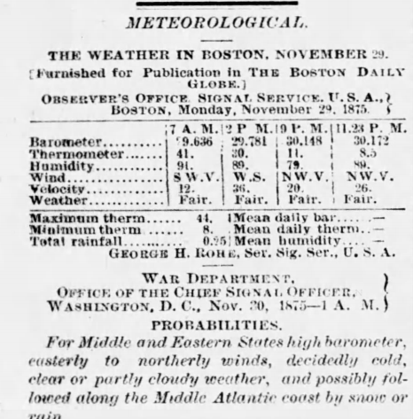
With a falling temp of 8.5°F just before midnight on 11/29/1875, I'd say that 10°F max high the next day looks good. I like the description, "decidedly cold". You think? Nice archive.
-
34 minutes ago, dendrite said:
Toss that 10°F max high and far.
Boston's record low for November was -2°F in 1875, so that 10°F low maximum may not be wrong.
-
9 minutes ago, CoastalWx said:
That was pre Logan.
They were talking Boston, whether Logan or otherwise.
-
According to WBZ-TV, there was a 22 low maximum back on 11/22/1891 for Boston, so perhaps the record was not tied. Or maybe they just got the date wrong.

-
2 minutes ago, Ginx snewx said:
He is saying relative to average I don't know the last time we pulled a -25/26 in winter. Last year was -23
I know he said relative to average. I'm just saying he made it sound as though we are already in winter.
-
23 minutes ago, qg_omega said:
I would wager this cold relative to average is the coldest of the winter
I would take that bet since we aren't even in winter yet, however you define winter, whether calendar or meteorological.


December Discussion
in New England
Posted
You'll be interested to know that TWC was just hyping that system. Under their scenario #1 they said all interests from Boston to DC should be monitoring this system for potential northeaster. Of course scenario #2 was OTS, but they didn't have a preference for one over the other, saying anything can happen, lol.