

78Blizzard
-
Posts
3,693 -
Joined
-
Last visited
Content Type
Profiles
Blogs
Forums
American Weather
Media Demo
Store
Gallery
Posts posted by 78Blizzard
-
-
11 minutes ago, Ginx snewx said:
No complaints, winter set in Mid November, 1 great storm of many to come. We missed out on 3 potential big storms, it happens but its a long way to March 20th.
Thanks for that voice of reason.
-
4 minutes ago, weathafella said:
I was surprised to see reports of RDU losing most of it. Hard to believe.
Also, Roanoke, VA has a metro pop. of about 300,000, and they are getting up to 18" in places. The annual average for the city is 18".
-
24 minutes ago, weathafella said:
Most of populated NC flipped to rain? RDW nearly a foot now mostl I’m hearing.
Greensboro was reporting over a foot.
-
1 minute ago, #NoPoles said:
Cold is boring...nobody rubs one off to cold and boring and pond ice...
Warmth in December is even more boring. But to each his own.
-
4 minutes ago, 40/70 Benchmark said:
Nothing else to discuss. There is zero chance of a significant snow event for at least like two weeks.
We could have been discussing more the bn cold we have had the last 3 weeks in all of the region. Just because there wasn't a significant snow event didn't mean we move right to "warmupville". We have discussed the cold, but I would bet there have been a lot more posts about the warm up.
-
1 hour ago, NorEastermass128 said:
We need a hit before Christmas or before NYE, the very latest.
Almost 100 pages only 9 days into the month...you’d think BOS would already have 20+ on the season.
I've never seen so much interest in mild ups, warm ups, or torches, or whatever you want to label them.
-
2 hours ago, weathafella said:
FWIW GEPS is pretty aggressive in making it cold here before 12/25. That’s a sweet pattern ...would be nice to have it right.
Don't know how good the GEPS is with the 2m temps, but after next weekend, even NYC doesn't get above 42°F for any day, with most days having highs in the upper 30's to 40°F. Doesn't seem too bad to me.
-
 1
1
-
-
16 minutes ago, Damage In Tolland said:
Snowy Wed in all of SNE seems increasingly likely
"Snowy" can have many meanings. I think you mean of the flurry variety, which looks to be mainly an E MA and Cape situation.
-
5 minutes ago, Ginx snewx said:
I think everyone here cept far Emass has used their snowblower, shovel at least once
Didn't even need the shovel for that November deal. After the rain sank the 5 inches we got here, the warmth following melted it quickly on the asphalt driveway.
-
41 minutes ago, Cold Miser said:
Time for the suicide by snowblower post.
I can be a bit superstitious at times. I haven't test started the snowblower yet, so the snow gods probably have planned on us not using them this winter. I'm going to start it up tomorrow. That'll show them, lol.
-
1
-
-
I thought there was a thread for winter banter and general discussion.

-
 1
1
-
-
2 minutes ago, TauntonBlizzard2013 said:
At least the moonshiners in Appalachia will have a chance at a white Christmas.
Roanoke, VA will exceed their annual snowfall total of 18" in this one storm.
-
Any packs up north will be in serious jeopardy next Saturday and also the following Saturday if the 0z GFS verifies, lol. Up to 6" of cold rain for ME next weekend.
-
4 minutes ago, Snow88 said:
Huge coastal storm next weekend on the GFS
Inland snow and coastal rain
Let's see if the GFS can lock that d9-10 system in like the Euro has for the last 4 days with our latest miss. I'm not betting on it.
-
2 minutes ago, USCAPEWEATHERAF said:
Yes potentially large and intense nor'easter
More likely a cutter, as most guidance is showing, the 18z GFS op notwithstanding. Even the 18z GEFS showed the op out to lunch with that coastal.
-
NCEP having issues? NAM already half hour late.
-
9 minutes ago, Typhoon Tip said:
That is an understatement ...
18 hours at storm maturation quintessentially timed for maximization of impact by positioning when it cuts off crawls a departure... Storm force pulverizing winds bearing some 3 to 5" of liq equiv QPF with temperatures falling through the mid 20s would probably be the biggest storm (including these recent 20"ers ...) to impact in well over 20 years.
D9 on any 18z GFS run isn't exactly inspiring much more than interesting curiosity ... no. But the GEFs derivatives have a PNA spike in that time range ...even though every other index plausibly teleconnected to our area of the hemisphere is July looking ... it is what it is...
No more so than the curiosity on this latest hope we have all been following for several days now since D9, lol.
-
1 minute ago, Baroclinic Zone said:
Epic Scooter shit streak gonna keep this next storm south.
It started out as a cutter, so that would be very disappointing.
-
Without the earlier hours, it's hard to tell how this evolved.
-
2 minutes ago, CoastalWx said:
,
It looks like the gfs got hung up at hr 120? Is this today’s 18z run?
It is hung up but it does show 240 hr.
-
35 minutes ago, CoastalWx said:
Besides I’ve been talking about relaxation. Just would have been nice to grab a little before we mild up. Other than the possible cutter, doesn’t look torchy. Might even still get interior snow.
The 18z GFS has turned that cutter into a coastal on d10, 966mb.
-
53 minutes ago, leo2000 said:
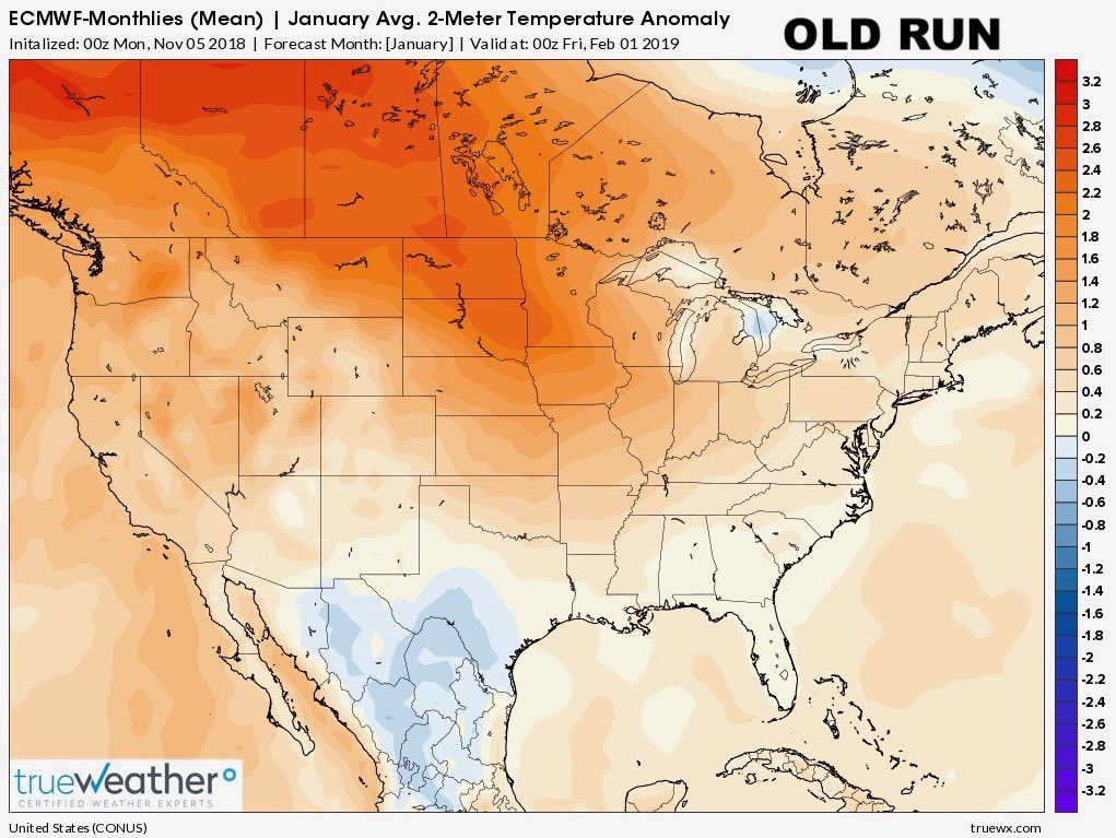
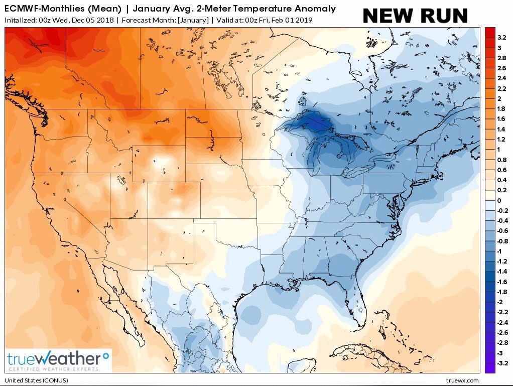
Just about everyone from the Great Plains on east is colder in that new run. We take.
-
Looks like a big change at h5 d9 on CMC, at least from the last couple of runs.
-
18 minutes ago, Greg said:
The hours that you really all want to focus on as we all know is on Tuesday Dec. 12 (165-177) hours. That, at this time right now, is the closest pass this potential storm this far out gets to us. I would rather it be this close now and watching it than it saying direct hit snowstorm right now. Just a hunch for now.
I think history probably shows that d8-9 modeled hits turn into cutters much more frequently than d8-9 OTS solutions turn into major snowstorms. Be interesting to know.
December Discussion
in New England
Posted
Yeah, right near the TN border, up about 3,000'.