ARyan
-
Posts
215 -
Joined
-
Last visited
Content Type
Profiles
Blogs
Forums
American Weather
Media Demo
Store
Gallery
Everything posted by ARyan
-
Getting quite a bit of lightning and thunder in Long Beach. It looks like the cell over Sandy Hook might graze us.
-
SVR potential late Wed-Thu August 26-27 NYC metro
ARyan replied to wdrag's topic in New York City Metro
The HRRR has another line developing from PA to LI in a couple of hours. It's not as intense but at the same time it might be under doing the current storms. -
SVR potential late Wed-Thu August 26-27 NYC metro
ARyan replied to wdrag's topic in New York City Metro
The warm front just enhances the shear locally but the rest of the region is still in play for severe weather. It's just that the tornado threat is much lower. -
SVR potential late Wed-Thu August 26-27 NYC metro
ARyan replied to wdrag's topic in New York City Metro
Wow. So, is there no tornado with storm or can you not see below the wall cloud? -
SVR potential late Wed-Thu August 26-27 NYC metro
ARyan replied to wdrag's topic in New York City Metro
Yikes! Some pretty low CC values with that storm near Amenia. -
SVR potential late Wed-Thu August 26-27 NYC metro
ARyan replied to wdrag's topic in New York City Metro
Looks like that was occluding and I would expect a new one to form to the NW of that one. Scratch that. Maybe not. -
SVR potential late Wed-Thu August 26-27 NYC metro
ARyan replied to wdrag's topic in New York City Metro
The line from Syracuse to Albany is the area to watch. SPC just issued a MCD stating that it's heading into a better environment and will likely become surface-based soon. -
August 2020 General Discussions & Observations Thread
ARyan replied to Rtd208's topic in New York City Metro
This reminds me of severe weather setups in Oklahoma. Sometimes the day before severe weather, the dewpoints can be really low, in the low to mid 50s. At night, the floodgates open up and the moisture starts streaming up from the gulf. -
We do get derechos but they're not nearly as common as they are in the midwest.
-
August 2020 General Discussions & Observations Thread
ARyan replied to Rtd208's topic in New York City Metro
Hearing a lot of thunder in Long Beach. Looks like something might be going up here. -
...and here comes the wind!
-
Got a good first taste here in Long Beach. Probably 20-30 mph gusts. Now I'm wondering if the flashes are lightning or power flashes...
-
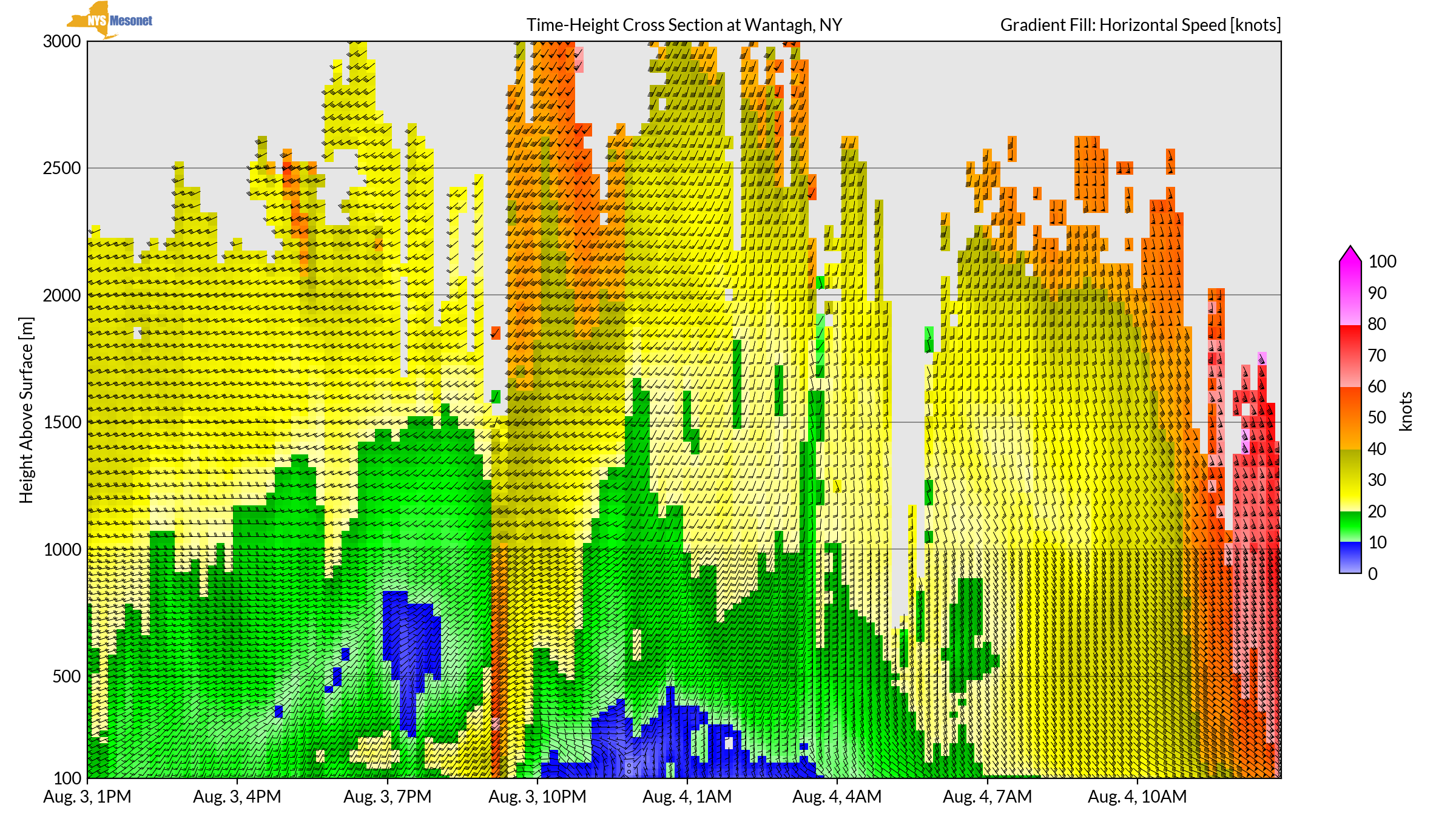
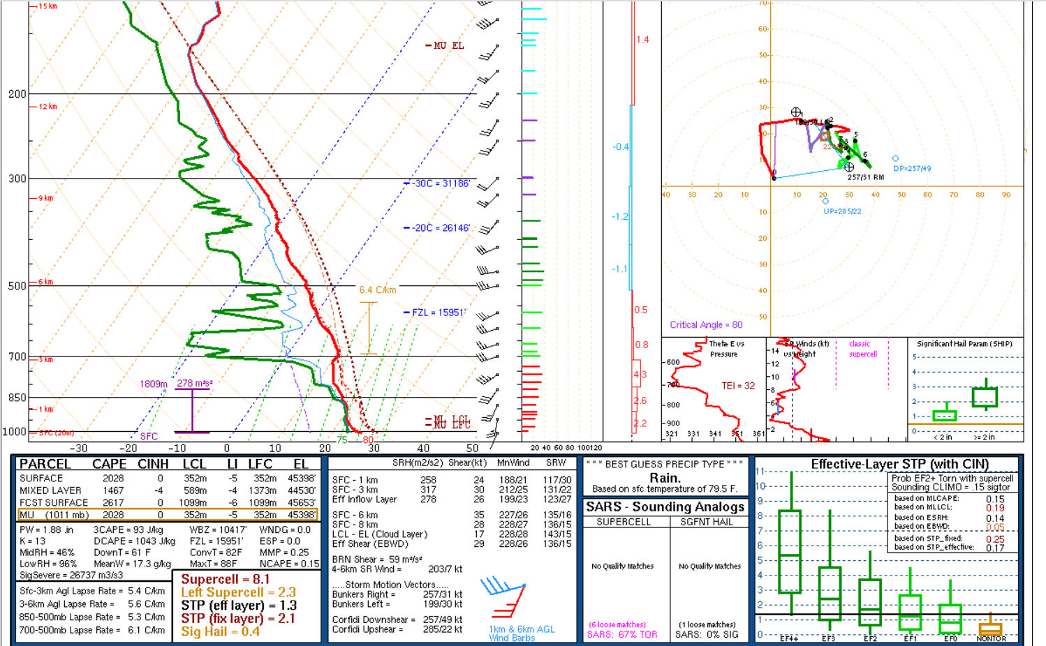
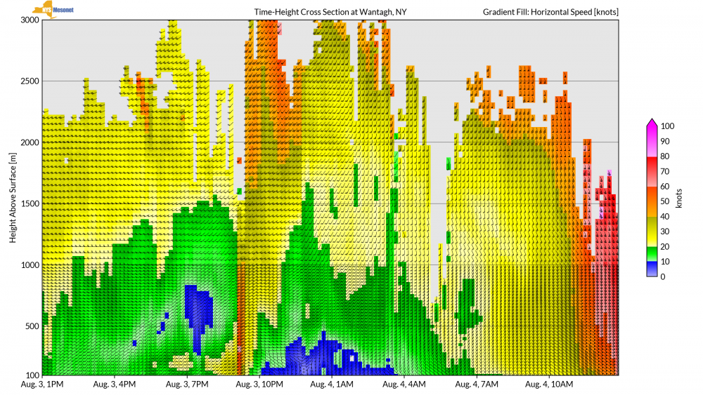
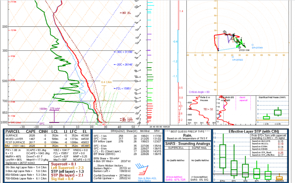
Yikes! This is about as good (bad) as it gets for the region. The lapse rates are still meager and I'd like to see the winds back a little bit in the lower levels, but otherwise...
-
Potential few SVR/FF events parts of NYC forum Wed-Thu 7/22-23/20
ARyan replied to wdrag's topic in New York City Metro
Anybody looking for archived (or current) radar data, check out WeatherScope. It's not radarscope nor GRLevel but it's Free. Also, I attached my script that you can open in the program and be set up for the NYC metro area. wxmap.wxscript -
Potential few SVR/FF events parts of NYC forum Wed-Thu 7/22-23/20
ARyan replied to wdrag's topic in New York City Metro
I'd lean towards a microburst but most likely just straight line winds. There's no evidence of a circulation in the water or rain. -
I'm in Long Beach about a block from the ocean. This afternoon should be interesting...
-
Reconsider majoring in meteorology!
ARyan replied to stormguy80's topic in Weather Forecasting and Discussion
Interesting thread. This thread will probably be responsible for me getting my M.S. in meteorology. Question for NWS/NOAA employees, what route did you take to get your job? I know it's incredibly difficult to get a government job. But what things can you do increase your odds or to make your resume better?