Hurricane Agnes
-
Posts
8,978 -
Joined
Content Type
Profiles
Blogs
Forums
American Weather
Media Demo
Store
Gallery
Everything posted by Hurricane Agnes
-
I actually hit 91 just before 2pm today. Didn't expect that. It was brief since there has been a hazy deck of high clouds most of the day, with occasional breaks of sun. Haven't seen or heard any cicadas here, nor seen any lightning bugs... and so far I haven't spotted any of those damn lanternflies either, but I expect those might be hatching and at one of the nymph stages. With the chill the first half of the month, a bunch of critters went on hold, but the temps the next week or so will wake them up for sure though. First tropical development underway early with STS Ana (fish storm), but will see how this year's hurricane season goes. Don't think it will be as insane as last year but you never know.
-
What I thought was going to be virga actually produced some flakes. Dews have finally made it into the double digits this morning (yesterday afternoon my lowest dp was -3). Currently 35 and overcast with dp 17.
-
Getting flakeage here. Was seeing what looked like lake effect streamers blowing across the state. Temp is currently 32 with dp 21.

-
Or give 'em some skis!
-
Wow. I wonder if the squirrel can even make it up to the top of that! But then they do call them "tree rats".
-
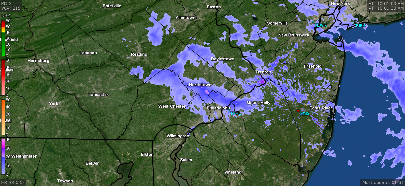
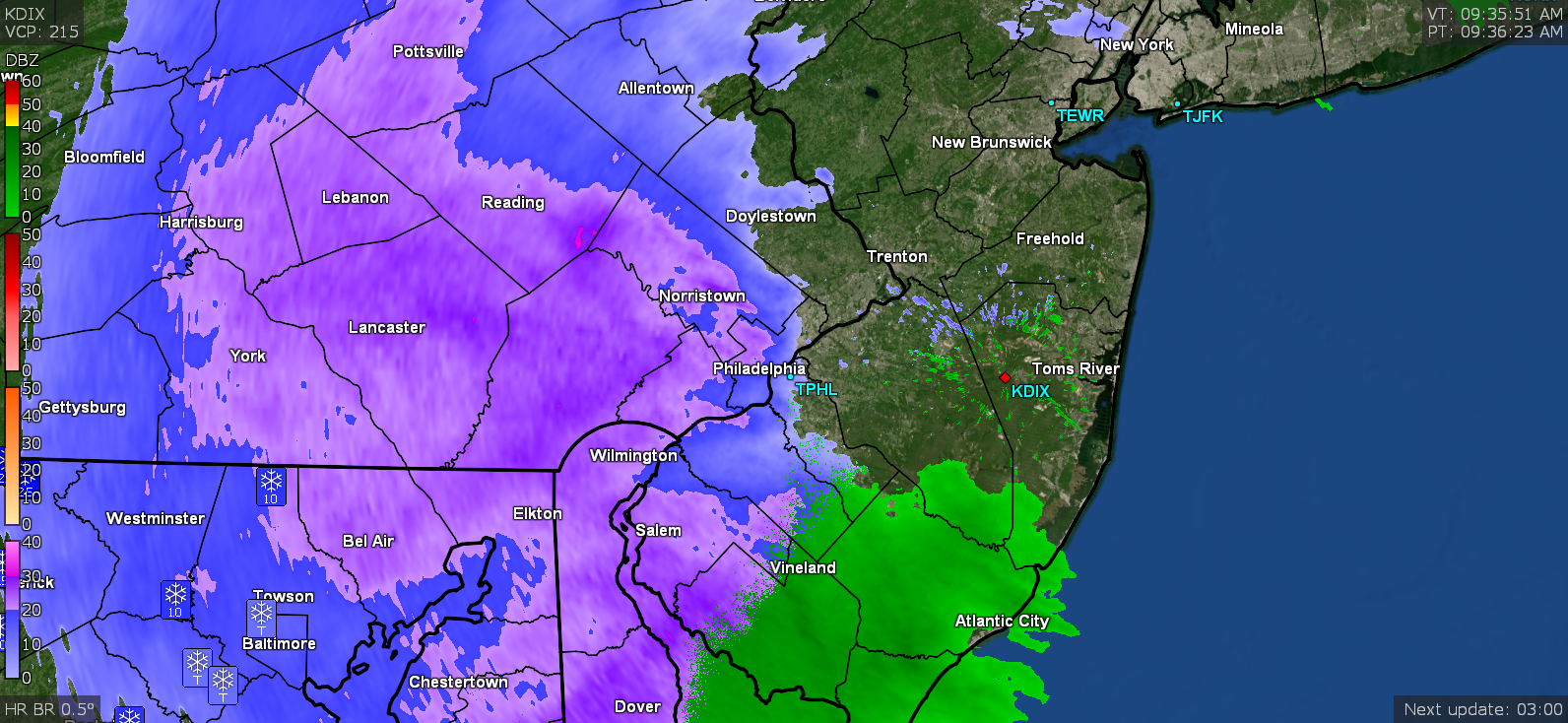
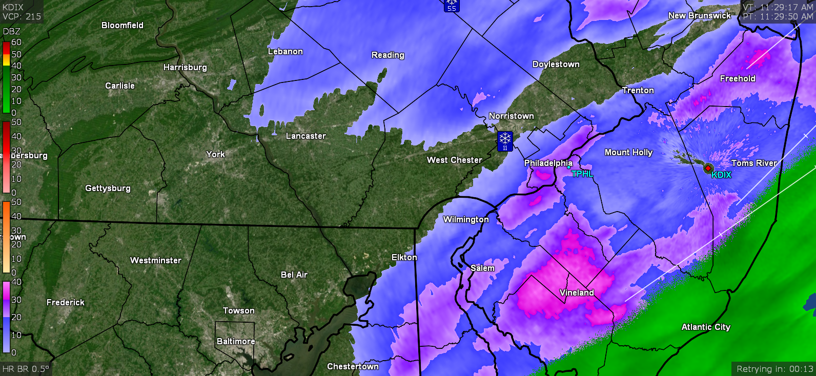
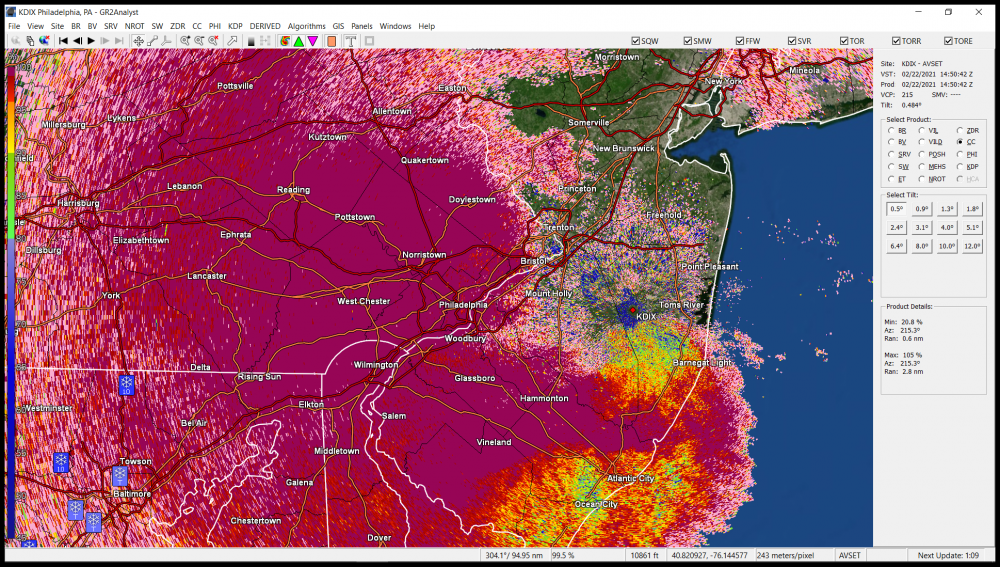
Mt. Holly's AFD mentioned a sudden convective line that formed in Jersey and zoomed off shore. You can see where it was starting up just before 2 pm and they threw up a Special Marine Warning on it as it exited land. Currently overcast and misty here and 35.


-
E PA/NJ/DE Winter 2020/2021 OBS Thread
Hurricane Agnes replied to Rtd208's topic in Philadelphia Region
Wowza! And got a few more inches on it too! With the rain and possibility of going back below freezing tonight, that will be a sealed-in glacier! -
31.29" with today's snow.
-
ANNNDDDD..... it's raining. Had 2.75" on the board before/just as it was starting. Temp 33.
-
That mix line must be close. Getting dinner plate flakes. Plus the streets that were plowed/scraped and treated about an hour ago, have caved again.
-
Starting to get the giant pancake flakes... Temp 33 dp 32.
-
Have been getting variable rates and a couple bursts finally caused the previously treated streets to cave. So far the board has about 1.5", but there appears to possibly be rain mixing in with the snow as it seems to be pretty wet when smacking the shrubs and other surfaces. Currently still holding just at or above freezing here and currently 33.

-
Finally more consistent SN and some of the colder surfaces are getting some stickage but the well-treated streets haven't caved yet. Have a coating on cars. Temp is down to 32. Keep forgetting I can do multiple panels with these apps.
-
Still light snow here but it is now starting to dust the cars. Treated surfaces still haven't caved yet. Temp still hanging at 33 with dp now 31.
-
Am somewhere between SN- and SN but nothing really sticking yet (except maybe on the snowpack). Temp is down to 33 but still above freezing with dp 30 and seeing a bit of fog with it. When I went out earlier this morning to clear off the board - OMG the 1/2" of sleet over the snowpack had me walking on top of a foot of drift that was barely sinking in. There was powder deep under it though when I shoved a small shovel down into it.
-
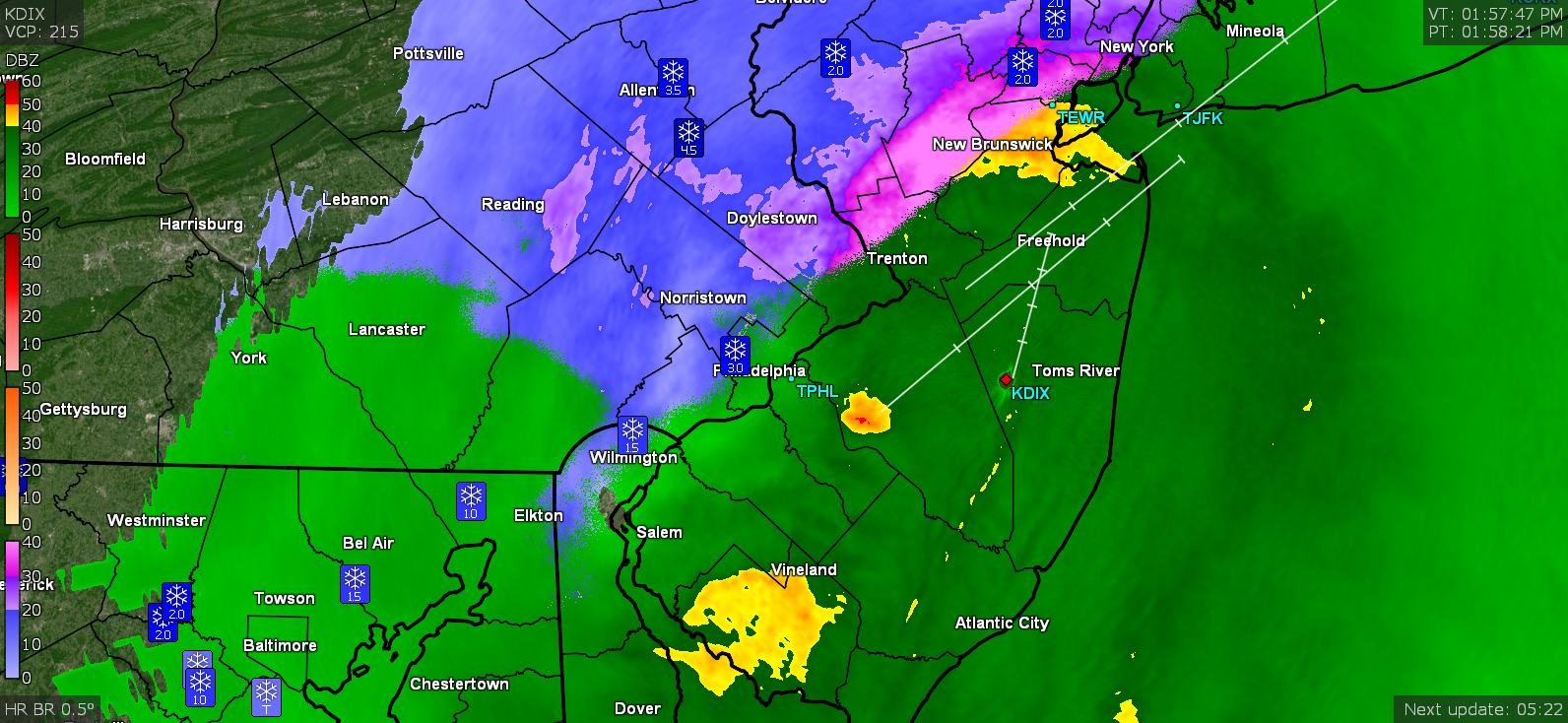
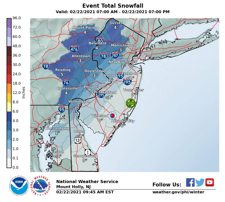
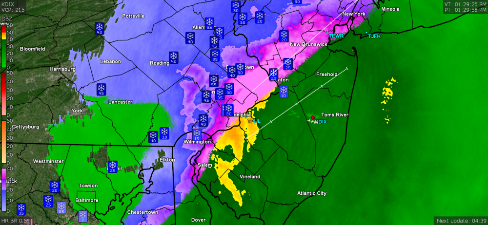
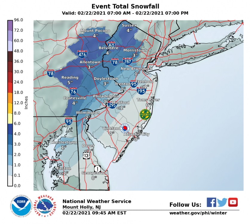
Here is Mt. Holly's snow map (as of 9:45 am). You can take it as their best guess! It will depend on how intense it gets to chill the warmer/treated spots but I expect there will be some initial "thump" of accumulation on the existing snowpack and other surfaces where you are but there is supposed to be an eventual shift of warmer air and changeover to a rain/snow mix. Whether that happens where you are will be the question.
-
My sis in Upper Darby texted that she was seeing flurries. I looked out my front and saw nothing but stayed there. About 30 seconds later, bam! Some clumped flakes. Currently 34 with dp 27 so already starting above freezing here.

-
28.54", putting me between 2015/2016 (26.45") and 2014/2015 (32.29").
-
True story but when the Flyer's won that first Stanley Cup, they briefly had it displayed in the lobby of one of the old bank buildings downtown, and I dragged my sister there to go see it after school one day (we were going to school downtown at the time). Bernie Parent, Bobby Clarke, Dave Schultz, Barry Ashbee...and Kate Smith singing the national anthem at the games. When Barry Ashbee had his eye injury, he was eventually admitted to Wills Eye Hospital, their original old building (now apartments I think) being right next door (an alley separated the buildings) to where I was in school (Masterman). Me and my classmates used to yell his name out the window across the alley while he was there... Yes, that was junior high. Buncha nuts.
-
Have had varying intensities of snow showers, with about 10 minutes of full SN, but with the temp at 32 and not intense enough plus at this time of day, nothing was sticking. Currently back to something akin to SN- - and I know whatever melted today is going to freeze solid tonight.
-
After pixie dust on and off all day, finally got under a tiny bubble of SN-. Temp holding at 32.

-
Still have non-descript lazy flurries and temp is 32 so stuff is melting.
-
Have mood flakes here that I suppose if they went on long enough, could add a dusting, but am not real confident. Temp still 31/dp 29. Am guessing south Jersey is getting a sleetfest.

-
Down to some lazy flurries and I suppose virga despite the radar look. Have a light 0.1" dusting on the colder surfaces and walks where the treatment washed away with melt. Temp is up to 31.
-
Getting white rain here now. Temp is up to 30.