Hurricane Agnes
-
Posts
9,336 -
Joined
Content Type
Profiles
Blogs
Forums
American Weather
Media Demo
Store
Gallery
Everything posted by Hurricane Agnes
-
Well Mother Nature "showed me". Bulls eye with > 1.5"/hour rates. Currently at 0.50" at post time.
-
LOL and right on queue... Temp is currently 73 with dp 67 and this little guy that just popped up.
-
I know people in TX haven't been complaining (but have been confused nonetheless). The people in the NW have gotten the SW's triple digit temps. Will be interesting to see when that pattern eventually flips (they usually do at some point).
-
My low today was a bit higher than yesterday's at 62. I was looking at Mt. Holly's forecast this morning and it appears the rain chances for today pretty much evaporated before my eyes (now progged mostly to the north or south of me), so out came the hose this morning. When I pulled it out, a few taunting sprinkles appeared but I was undeterred and plowed on... Currently overcast and 71 with dp 65, so definitely feeling much more humid today.
-
As a side note on Limerick, I remember back in my senior year of HS when my AP Physics class took a field trip to that Limerick plant when it was still under construction. This was back in '78/'79 and I think one of the cooling towers may have been built by then but it would be awhile before any reactor was started up and generating electricity. We got a little dog and pony show from PECO about how the reactor would work (basically having the heat boil the water to create the steam that would turn the turbine to generate the electricity) and I remember they had some interactive display things including one of those bicycle generators that you could try out to light up a bulb. Back then they "promised" that when the plant came online, it would drop the average electric bill down to $3/month "by 1995". I think we actually did that trip before Three Mile Island had it's partial meltdown. Since I got fringed by the rain, gotta get out there and water now but the temps are perfect otherwise. Currently 76 with dp 52 and blue sky (the high clouds have pretty much cleared out).
-
Well I was just hunting around on the map for the EF3 in Trevose and realized that wasn't far from where I used to go to one of the drive-in cinemas in the area - the Lincoln Drive-In (before it started showing the porn movies ). It was not that far from that Faulkner dealership that took the brunt of the tornado. I remember seeing the original "The Godfather" and "Ben" there when they first came out in '72. Back then, they would have the $1 a carload specials. From what I read, the location is now the Neshaminy Interplex office park. Am currently up to 71 with dp 51, and a deck of high clouds have been coming and going, but are clearing out.
-
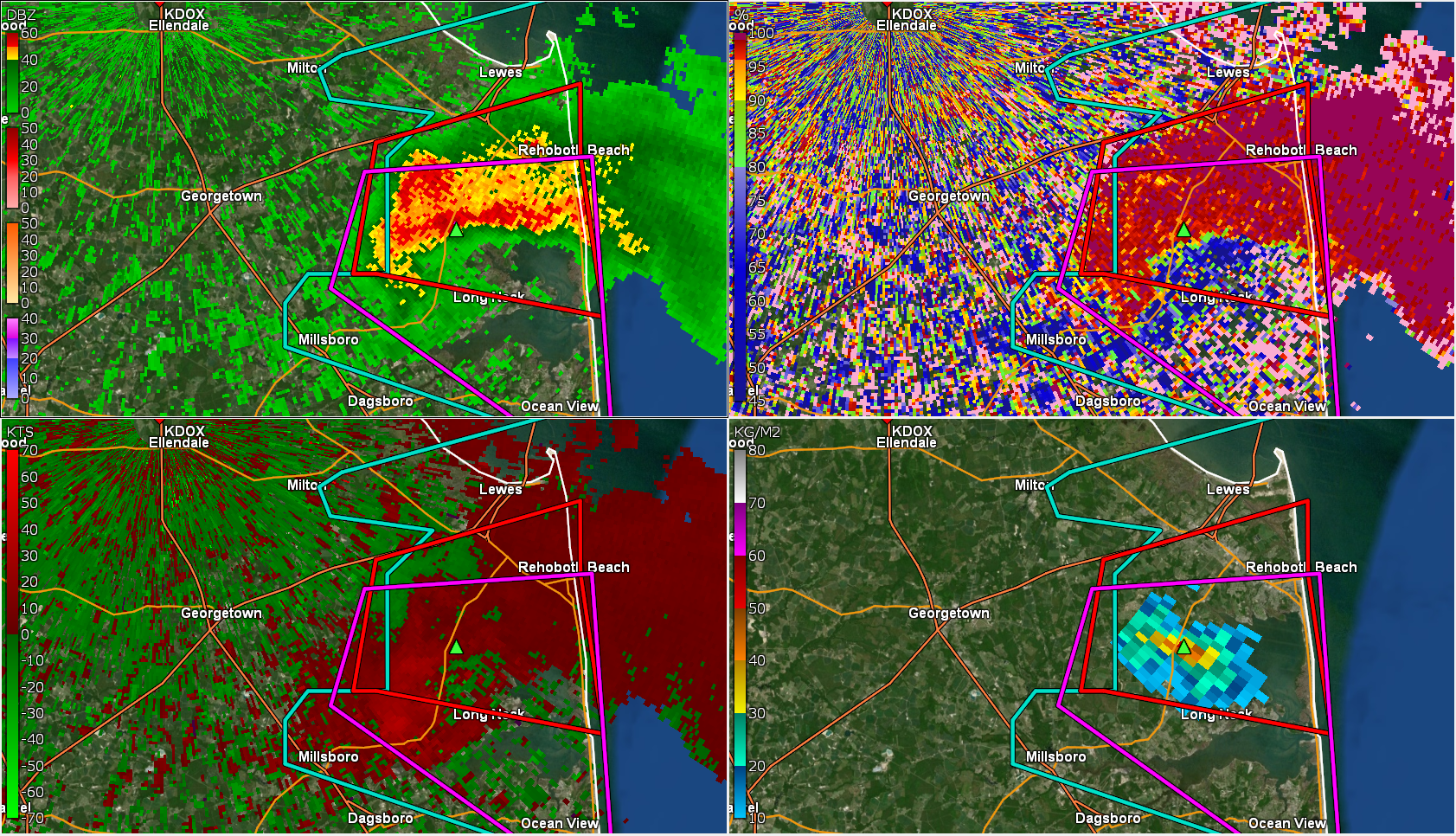
I'm still waiting to see what the verdict was on the Rehoboth/Dewey Beach possible tornado... I know it was on Mt. Holly's review list. https://www.capegazette.com/article/home-struck-lightning-tornado-spotted-july-29-storm/224448 Maybe it was just considered a waterspout and/or a funnel that didn't touch down. ETA - I don't even hear about tornadoes in Kansas anymore. I guess that was so 1939.
-
Apparently the last EF3 in the state was in 2004 in Campbelltown, which is just outside of Hershey - The Limerick one was in 1994 - https://www.nbcphiladelphia.com/news/local/20-years-ago-deadly-limerick-township-tornado/128147/ To this day I always say they were fortunate it didn't damage that nuclear plant or its cooling towers. In fact I saw where NRC had a conference this past March to present updated tornado risk maps to be used to modify the building design criteria - mainly due to what happened in Joplin (which was 10 years ago this year). As an obs (and I know Birds69 is cheering this it along with the Eagles training camp start ), my low so far this morning has been 58. It's currently 59 and partly cloudy with it being not long after sunrise, with dp 52.
-
Whole pile of tornado reports from Mt. Holly today - And the outcomes (I expect the Rehoboth/Dewey Beach area one in Delaware is still pending) - As an obs, I actually did drop a degree this morning for a low of 71. Made it up to 87 today for a high, and although it took awhile, the dp finally dropped into the 50s, and it's currently 84 and mostly sunny, with dp 55.
-
Have been looking at the damage reports. That area has really been hit this year between the flooding rains earlier this month and now this. So far my low this morning has been 72 and it's currently 72 with dp 70 about 30 minutes before sunrise, and partly cloudy.
-
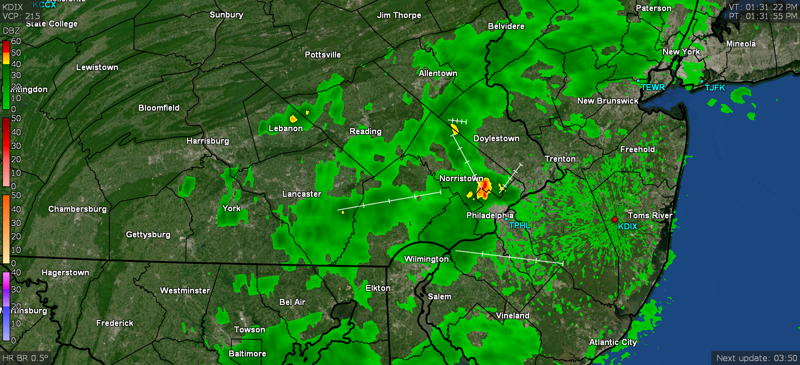
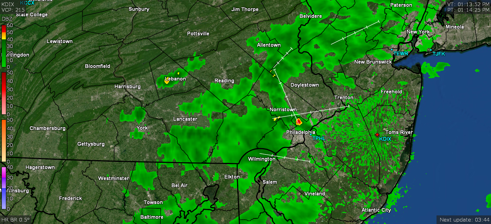
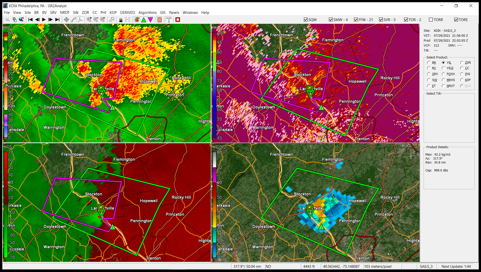
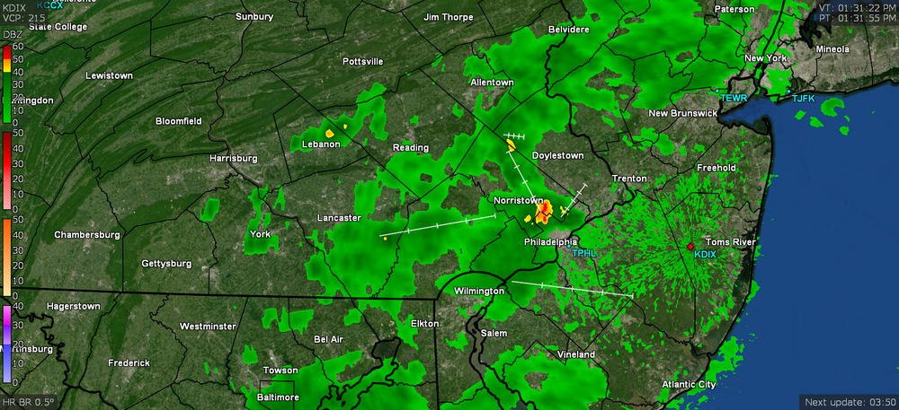
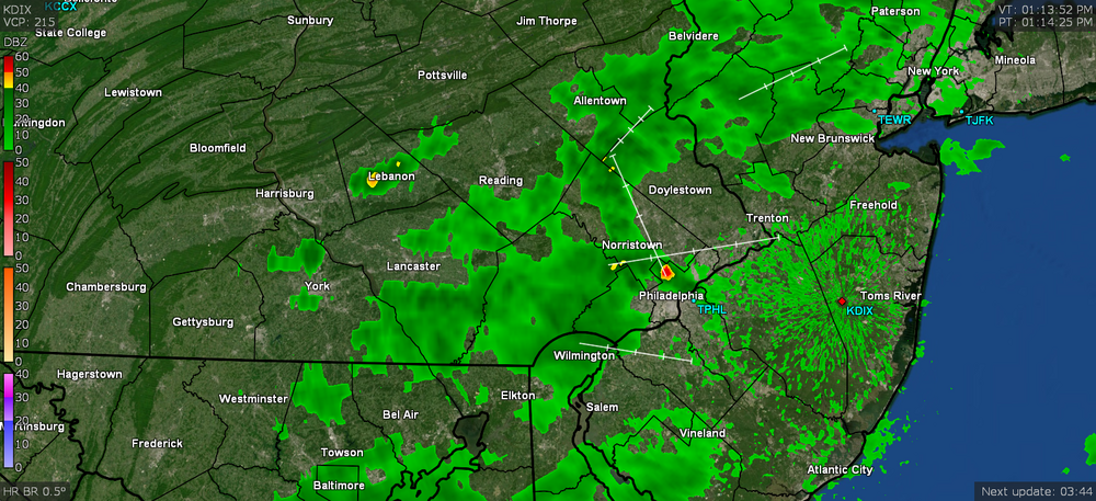
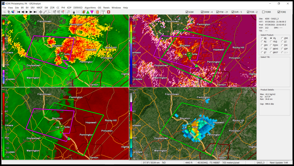
Well Mt. Holly has been busy this evening. I had been looking at the various TORs around area including the Bucksco ones. Meanwhile, the rain pretty much missed me to the north and I only got 0.03" (at least for now). Am hoping when the cold front comes through, there will be a little rain with it but am not optimistic. Current temp is 78 with dp 73. Snapshot was from the TOR around New Hope.
-
So far have 0.02" of light rain. Temp currently 77 with dp 74 and misty.
-
TOR up, north of Kutztown.
-
Getting light rain. Not enough to tip the bucket yet but enough to wet the walk. Current temp is 79 with dp 73, and it did manage to get to 82 today as a high (so far, although that will probably be it).
-
You spelled "Pittsburgh" wrong.
-
Been watching the TOR by Rehoboth.

-
SPC up with the Tornado Watch (did see the Warning over in Western PA) -
-
Unless and until the sortof stationary front moves northward as a warm front to clear the clouds, then we may be socked in (with on and off breaks) for awhile. Current temp here is 76 with dp up to 70 now.

-
Another 69 low this morning and it has been rather unsettled as some negatively-tilted little line of pop-ups formed and passed over part of the area. The northern extent of it pretty much dissipated when it got to me but the overcast reminded me to put my patio umbrella down. One of my neighbors had theirs up during that straight-line wind event and it was only because of how the back of their house faces that their umbrella managed to wedge up against the house and part of the privacy fence when it overturned, and not go soaring elsewhere. Currently 73 with dp 67 and yup, it's a bit steamy out there this morning. Will have to watch all that stuff going on in the MW to see what manages to survive this far to here.
-
Might be short-fused focusing on a certain part of the CWA. I expect there to be a Severe Thunderstorm Watch lofted before then.
-
I know there has been a rumbling of thoughts about an upcoming pattern shift that might support derechos, although not certain if any that are progged to possibly form in the MW, would actually make it this far into our CWA. However they have done so in the recent past so... something to watch for.
-
Cosme (" '89 " because the name was used again multiple times since), was a Pacific cyclone and when it crossed over into the GOM as a remnant and regenerated, it was renamed as a new TS - Allison. We got a good soaking from the moisture that got shunted up here from it in the Philly metro area. The day before it hit, we had been in Mexico City and touring around the Pyramids of the Sun and Moon and it was windy. The guides were really anxious and jittery about it and one of them finally exclaimed that it had never been that windy like that there that he could recall (the city itself is like 7400 ft altitude). We flew out of there later that afternoon and went from mid-70s and low humidity to an absolute slop bin of 96 and what had to be an 80 dp in Acapulco. That next evening on the TV in the room (stations all in Spanish), one thing stood out in one news segment's headline - the word "Huracán". The open air lobby ended up getting flooded (but then apparently they were used to that), power was out in the hotel for awhile, and there was a general warm showery rain on and off the rest of that next day, but it was interesting to see what it was like being in the "eye" of a hurricane (although it was night and it was as if the storm was over, but it wasn't). After that, the NHC no longer renames storms that cross between the oceans if they maintain some sort of remnant and restrengthen. Sorry about the OT, but a little color analysis since the Atlantic is "quiet" at the moment. I expected it to get somewhat hottish today (although not like yesterday) but it didn't even really do that. So far my high has been 86 but it's currently partly cloudy and 84 with dp 64 (so bearable and more "typical" for mid-late summer).
-
I was down in Acapulco on vacation back in 1989 when Hurricane Cosme hit, making landfall just east of where we were, and the winds/wind gusts were probably close to that 80 mph. Cosme eventually cut across Mexico, reformed in the GOM, was renamed to TS Allison, and hit Texas, so by the time we got home, we got hit with it again in remnant form. After that one, NHC no longer renames systems that cross between the Pacific & Atlantic (if they maintain some type of circulation even as a Low). They didn't evacuate us or anything (the hotel was really solid, made of concrete, and anchored right into some rocky outcrops of Acapulco Bay). But there were a ton of ships, including some naval ones, that had come into the bay to ride it out the day before. The max winds before landfall were clocking in at around 86 mph. I remember a lot of convection and the eye passed overhead since everything went calm and the stars were visible. Then all hell broke loose as the backside of the storm came ashore. We weren't about to go outside although we did pop out on the balcony a few times but this was all happening at night, so it was hard to see anything. People who lived on the other side of the cliffs were flooded out. The surge brought the water all the way up to and over the pool earlier that afternoon. To throw an obs in since I think I've hit my high - 93 was it. Currently 88 and partly cloudy with dp 64.
-
Here are the tweets from Mt. Holly for our area about that - After what happened just over a week ago with that straight-line winds/hail event, this is something that will definitely be helpful. As an obs - my low this morning was 69 and I did briefly tap 93 just after 1 pm today. It's currently mostly sunny and 91 with dp 68. You can feel the heat but it's not quite soupy (although the humidity is a touch higher than yesterday).
-
Looks like 91 was my high for the day and it's currently mostly sunny and down to 89, but the dp took a nice plunge and has been bopping between 57 & 58. To have 35% humidity in late July is a bonus.