Hurricane Agnes
-
Posts
9,336 -
Joined
Content Type
Profiles
Blogs
Forums
American Weather
Media Demo
Store
Gallery
Everything posted by Hurricane Agnes
-
There's a TOR up for the Flemington area. I know an earlier warning had a spotter see a funnel. Still nothing measurable here and temp down to 86 with dp 77.
-
Getting some light rain, enough to start wetting the sidewalk but not measurable yet. Temp is down to 87 but dp is 77, so still juicy.
-
Hearing thunder and the lightning sensors all around are lighting up!
-
It's clouded over here but the rain has been missing me entirely. The clouds did drop my temp down to 90, but the dp is still up there at 75.
-
Getting some big raindrops as I get fringed by some small popups coming in from the SW of me. Temp dropped a few degrees to 92 with dp 76.
-
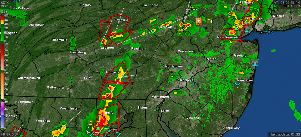
I can't believe I that I ended up looking that up and then watching Youtube reviews of it. If it can nail lanternflies then it would be worth it! You might still get sideswiped by the connecting stuff between those split cells. Am watching some little blips trying to bubble up in central Delco and southern Montco to see if I can get something. Poor plants are frying. Sun has been in and out and am currently bopping between 94 and 95 (am at 95 at post time) with 76 dp.
-
Now at 95 with dp 77. Mailman just deposited some mail in my mailbox... Poor guy.
-
You made me look and yup, my sensor is lighting up! My temp briefly hit 94 but it's back down to 93.
-
SPC up with the Severe Thunderstorm Watches for the CWA (pretty extensive area too) - It's literally the entire states of NJ & DE and 3/4 of the state of PA! Currently 93 with a 77 dp and some cumulus starting to bubble up.
-
Or something out of a Louisiana bayou. High noon (yes I did briefly go out and run back in), and it's 93 with dp still bopping between 78 and 79. Sometimes on days like this there is an active SW breeze but today so far, barely a breeze to be seen or felt.
-
Yeah I think it's all the brick and stone around here that absorbs the heat and radiates it, especially if there is extended heat. I am probably about 150 ft from a strip of woods, but that is to my east and it would have probably made more of a difference if they were near the west side. If we hadn't had as much rain as we have had so far this year, then we would have certainly reached triple digits this summer, which will probably not happen this year given the pattern (unless the pattern does a major change and shuts off the faucet). AND... as I type this, I'm sitting at 90, with a 79 dp (that is bopping between 78/79).
-
I'm gonna need to put some boxes in the recycle bin and then run back in. Up to 89 here now, with some scattered clouds, and a dp of 78.
-
Barely after 8:30 am and already up to 85 here with a dp of 77. I'm afraid to go outside. I ended up with a 74 low this morning.
-
That "Moderate" risk is designation rare for around our CWA and a bit concerning. Currently 75 here with dp 71 and will find out later if that will be the low for this morning.
-
Made it up to 94 as a high for the day (so far but probably will be a final). This is the 21st 90+ high day IMBY since May, with 3 (non-consecutive) days in May, 11 days in June (including 2 heatwaves of 3 or more consecutive 90+s), and 7 in July (with what is now the 2nd heatwave of the month, with 3 or more consecutive 90+s). It's currently 91 with dp 70 and
-
LOL I had to get out there and do some light watering because I'm afraid if I do a deep water, then some cell will sit over the area tomorrow and unleash, and the plants will end up with yellow leaves. My "low" was 76 and I've already touched 89 this morning. Dews are moderate but it's currently sunny and 89 with dp 72.
-
I think a lot of where you see this issue too is with "port" cities in general that still have significant industrial land areas with sprawling facilities strung along the waterfronts. Those facilities generate jobs but they are rarely "landscaped" to include some green space. I think they are trying to remedy some of that down here across the river with Camden's waterfront that still has its docks and piers, but with some added park development around them (e.g., near the old RCA building that has been converted and the Campbell Soup factories that were imploded some time ago) - Here in Philly, William Penn envisioned a "Greene Countrie Towne", including four "Squares" as parks in the original city design - The squares are all still there almost 340 years later. But even with that, the industrial age came full bore and the city managed to keep them up and expanded them as the city expanded, while the industrial waste and pollution were killing our 2 rivers. Fortunately efforts were made to clean and begin to restore the rivers, and they continue to add more green areas. The one significant thing that I recall almost 20 years ago, was a work training trip to San Francisco, and the plane circling over the city before landing. I had never in my life seen an area so built-on and lacking trees than San Francisco. On the street level, yeah you have some street trees (mostly eucalyptus and old magnolias) but outside of Golden Gate Park (their equivalent to Central Park), it was jarring. Many of us here in Philly metro are under flight paths and if you have been on a plane circling overhead, you do see lots of wooded areas, particularly over the rim counties. But there, nope. Even NYC (not even counting Central Park) has the more "residential" boroughs with trees and little parks.
-
Looks like my high ended up being 93 and I'm currently partly cloudy and bopping between 88 & 89 with dp that has shot up to 74/75. I heard Glenn on KYW earlier and he said we're stuck in this until probably Monday. Mt. Holly has the heat headlines up but has forecast a bit of a moderating ("cooler") pattern change for the new week, with the WAR moving away and an incoming trough.
-
I saw Accuweather had an article on research done to look at the phenomena of the "urban heat island" - https://www.accuweather.com/en/weather-news/how-these-5-cities-became-the-most-intense-urban-heat-islands/981815 The data came from an independent climate research organization named "Climate Central" - a group of scientists and journalists who do deep dives into weather-related climate data and release reports. In this case, one of the researcher's schools partners with NOAA to contribute their data to them. This particular report is here - https://medialibrary.climatecentral.org/resources/urban-heat-islands where they took a look at 159 cities across all 50 states and applied similar methodology originally developed by other researchers who had come up with a model to measure, evaluate, and generate what they dubbed an "urban heat intensity" value (used for select European cities based on the prevalence or absence of certain features including population, building heights/density, greenspace, etc.) - https://www.nature.com/articles/s41598-020-75018-4 Their report brief is here (PDF) - https://medialibrary.climatecentral.org/uploads/general/2021_UHI_Report.pdf The generic graphic of how they categorize environments is this - Accuweather posted the top 5 "urban heat islands" and the Climate Central site posted the top 20. Philly (and I suppose that might mean some its immediate adjoining rim communities) was in neither the "top 5" nor the "top 20" list. The higher the value, the more intense the heat island. So I had to dig and dig and did find a link to their data graphic and you can select a city here - https://www.climatecentral.org/outreach/alert-archive/2021/2021UHI.html (and the link includes the CSV spreadsheet file for the list of the cities and ranking). From the raw numerical list, Philly came in (alphabetically) at #37 and they had an option to generate a graphic - In actuality (looking at the spreadsheet list), since many of the cities were "tied" with other cities based on their scores (in our case listed as "6.29" in the spreadsheet and rounded up to 6.3 on the graphic), we were tied with 7 other cities for 13th place (if you group the ties and re-number). Renumbering based on lumping each of the groups of ties in their own single rank, yields a total of 21 rank slots. Interestingly, there were something like 62 cities tied for 15th place (with the rank renumbering). Believe it or not, using Climate Central's straight numeric ranking (not counting ties), Erie ended up in the top 20 and was the only PA city that showed up in that top 20. Using the renumbering would make it #9. Allentown came in at #40 (or #14 renumbered) - and Pittsburgh came in at #45 (tied with Allentown for a renumbered #14). For both NJ and DE, they only had 1 city each evaluated - Newark, NJ (#2 and also a renumbered #2) and Wilmington, DE (#27 or renumbered #11) - (*note that I am only displaying the graphics for the Philly Metro /Mt. Holly NWS cities)
-
Ha!!! That's been my problem. Too many "projects" and not enough time to devote to them if something "glitches" and ruins the flow. I have been doing the weewx stuff in the middle of re-doing my local network (I recently bought my own gateway/router and one of my trips this morning was to take the Comcast rental one back). So getting all the stuff set back up correctly and in the configuration that I want, is disrupting my progress.
-
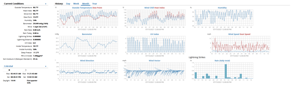
See... that's what I've been doing fooling around with one of the home weather programs - weewx - which I have running on a little Raspberry Pi and that displays my PWS data with the Pi's local Apache webserver that I can connect to through a browser. To do it, I have a little Ecowitt GW-1000 guy that is listening for the data coming out of my PWS and its sensors, compiles and formats that data, and then loops it to weewx to generate the reports and graphs. I am still trying to tweak the thing, which involves modifying the text components of the config files. I added a quick snapshot of the top part of a page below showing some of the plots for the month to date so far. I can change the page colors, fonts, chart scales, etc., although I have been having an issue trying to get an alternate measurement unit recognized for the soil moisture sensor (which is defaulted to a unit that my sensors don't use). In general, I work on it for awhile and then something else demands my attention, so I stop, and eventually get back to it. Had to go out to run some errands this morning and although the dewpoint is "lower" (in quotes), it's still pretty brutal out there. Am currently partly cloudy and at 91 with dp 71.
-
My low this morning was 73 with none of the stratus/fog experienced the last 2 mornings. Am currently mostly sunny and up to 80, with a noticeably higher dp of 73 (although I understand it's progged to mix out later ahead of the blast to come tomorrow and over the weekend).
-
Final high for today was at 4 pm when I hit 92. It's currently mostly cloudy and 84 with dp 71.
-
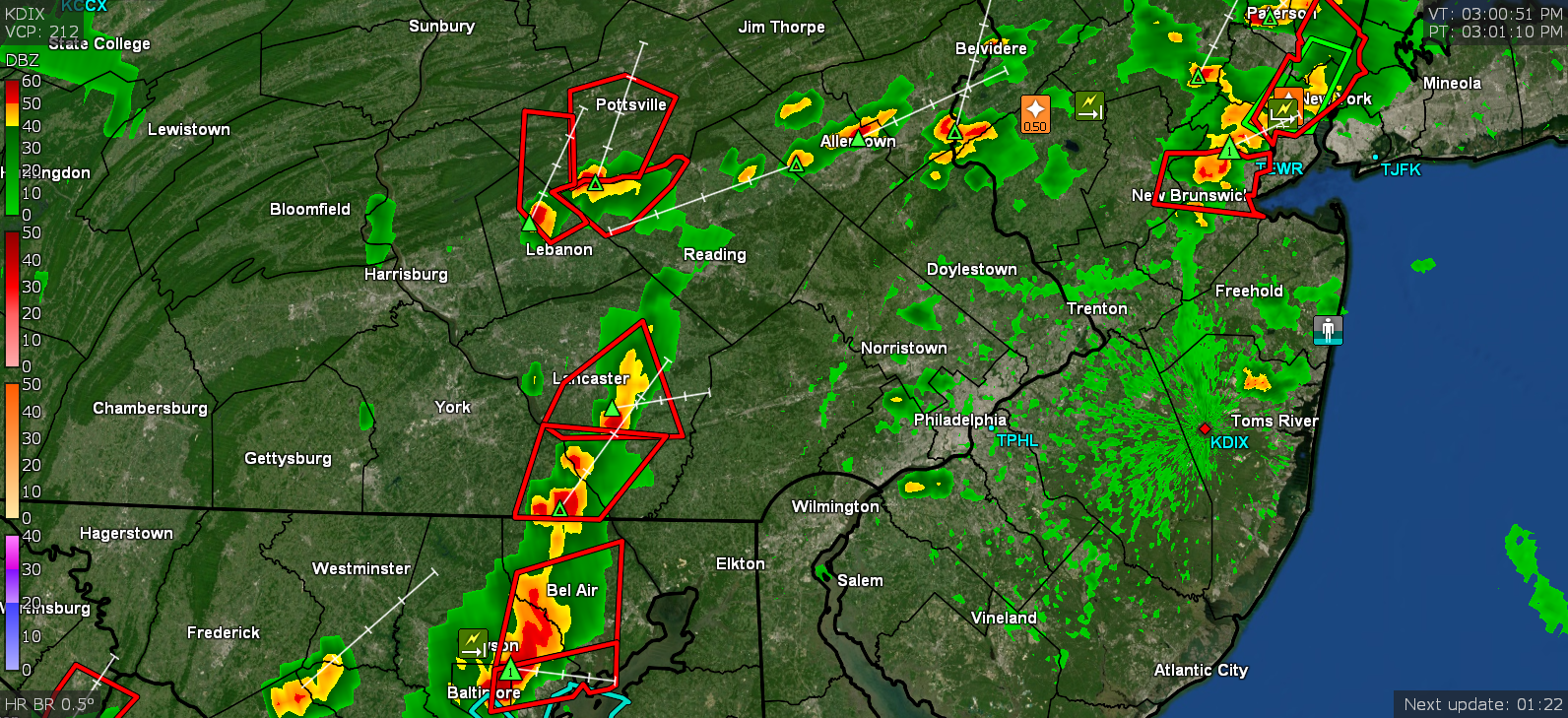
Hit 91 as a high so far today although the dp did thankfully drop "down to 71" from an earlier 74. Currently 91, mostly cloudy with breaks of sun, and unsettled looking as the radar starts to light up.
-
Temp is up to 88 at noon, but the dp is "only 72" (and not 77/78) so... There are some ominous-looking cumulostratus passing overhead moving east but I know they are basically harmless.