Hurricane Agnes
-
Posts
9,336 -
Joined
Content Type
Profiles
Blogs
Forums
American Weather
Media Demo
Store
Gallery
Everything posted by Hurricane Agnes
-
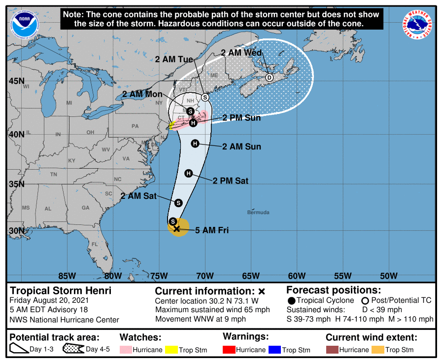
I was watching Levi Cowan's video outlook from last night (and even since then, the track has shifted further west). The variables he outlines regarding the strength/position of the trough around us and the position of the ridge to the north, will make the difference on where Henri drifts and turns. ETA - I just looked at the 6Z HMON and it has Henri doing a direct hit right into western LI and NYC. The 6z HWRF has it doing some kind of inland loop - crossing eastern LI and moving inland to CT, and then does a little loop (goes westward across southern NY, then heads back east a bit, drops south, then shifts southeast, and finally exits across eastern LI, and goes out to sea. I do know it's the 6z though.
-
Yeah, that's why I'm watching - not so much for a direct hit down this way, but any rain bands... We have some spots around the area with antecedent wet conditions and still recovering from flooding, with more progged for the weekend, so it could spell some issues. But if it did hit NY (as a hurricane to boot) then...
-
And here we are, getting closer and closer. Currently overcast, with some breaks here and there, misty and wet as well (although not enough to tip the bucket) and 74 with dp 70.

-
I was fruitlessly trying to find something too but neither seemed to have obvious rotation. It's possible that due to the moisture laden environment since Fred had come from the tropics, the rain component in the returns might have obscured those details (I recall reading somewhere noting that could happen where there could be a tornado but it's hard to make out on radar due to the precipitation intensity). Well I'll be keeping an eye out for this - Right now as a TS, it's pretty compact but once it hits that bathwater and gulf stream, it will be interesting to see what it does if/when it strengthens to a hurricane. 89 ended up being my high today and it is currently partly sunny and 84 with dp 72.

-
Had heard on KYW that Mt. Holly confirmed 2 tornadoes and then saw this - So far my high today has been 89 and the sun has mostly been out today, although the dews continue to be moderately steamy. Currently partly sunny and 88 with dp 73.
-
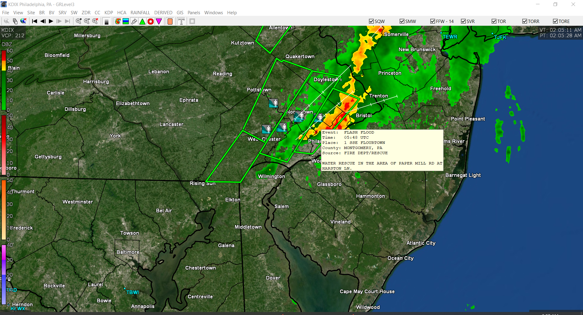
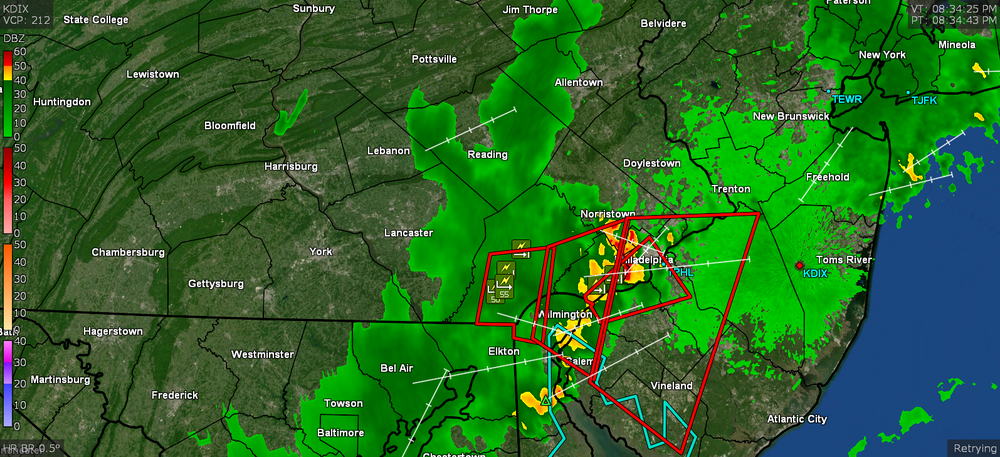
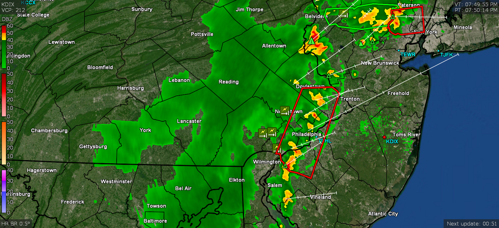
Mt. Holly reports what is submitted via CoCoRaHS here - https://www.wrh.noaa.gov/total_forecast/getprod.php?new&prod=XXXLCOPHI&wfo=phi and any Local Storm Reports here (if/when people submit them) - https://www.wrh.noaa.gov/total_forecast/getprod.php?new&prod=XXXLSRPHI&wfo=phi and Public Information Statements here (if/when people are submitting them) - https://www.wrh.noaa.gov/total_forecast/getprod.php?new&prod=XXXPNSPHI&wfo=phi At the moment, the CoCoRaHS reports seem to be the most complete, although there are only a handful of Philly reports. I recall last week the Phillies had rain delays on 2 consecutive evenings - 8/10 & 8/11 (one of my BIL's was at the first game). Sometimes you guys get the northern fringe of the storms that come through northern MD and Wilmington, DE. Whenever I have been running either of my doppler programs (GR2Analyst or GRLevel3), I don't recall seeing mpings or other spotter reports from down there though outside of the airport (KPHL), which is the official reading for down there too. I attached a radar image (with 3 overlapping severe thunderstorm warnings) over S. Philly on 8/10 just after 8:30 pm & on the look on 8/11, about 7:50 pm.
-
Will have to say that however innocuous Fred was when it fell apart over Cuba and never made it to Hurricane status, it still packed a wet wallop once it regenerated itself! Wasn't expecting that rain band line to hold together although we were certainly warm and juicy enough this far east to prime the pump... Currently down to 73, which may end up being my low, and cloudy with dp 73
-
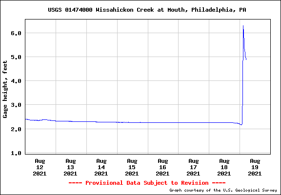
The 3.45" was my final for the event (now at 6.78" for the month so far). I saw where the Wissahickon Creek went out of its banks (I think ~5ft is flood stage). I'm good through the weekend. It's currently a very wet and mostly cloudy 73 with dp 73.
-
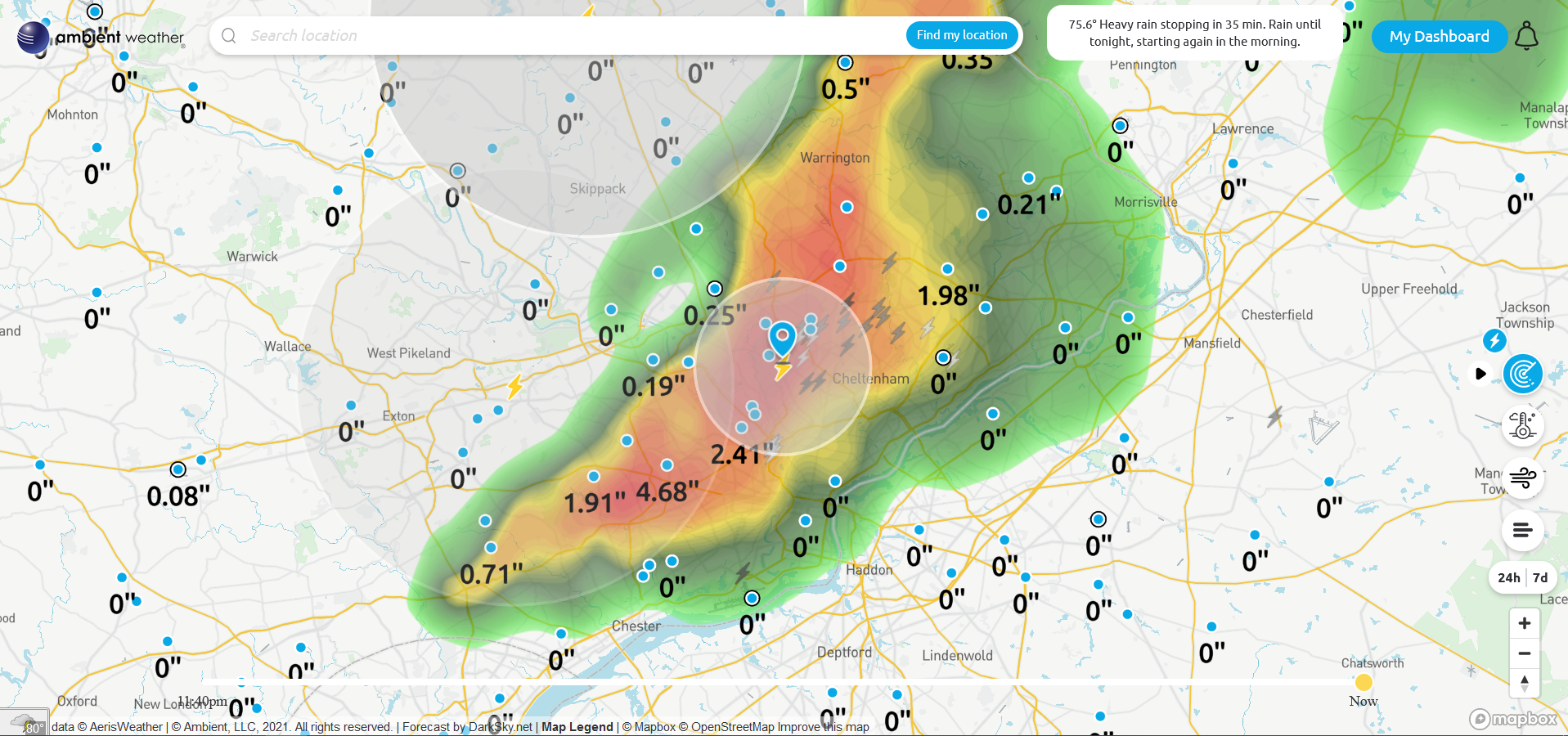
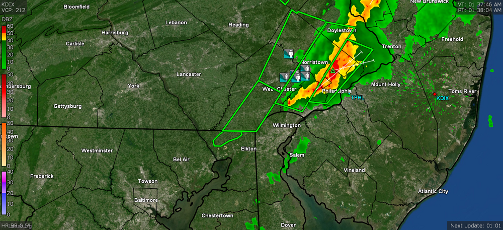
Looks like Flourtown was reporting a water rescue. I think the heaviest is now pretty much past and currently have 3.42" in the bucket with 0.61"/hr rate. Like a month's worth of rain in an hour. Temp 75 with dp 74. And with that, time to go back to bed. The lightning/thunder has pretty much ended for now. ETA - now at 3.45" and light rain at 2:30 am.

-
Still >3.5"/hr rates. Now at 3.10" for the event at post time.
-
Still getting raked and now up to 2.81" of rain from Fred. and still well over 3"/hr rate but dropping. Temp is 75.

-
Yes! The line has been solid coming through. Now closing in on 2" from this so far.
-
Am over 5.22"/hr rates. Am at 1.82" at post time.
-
Now almost up 4"/hr of rain - at 1.17" at post time. Temp is down to 76
-
It has been non-stop lightning/thunder for the past 2 hours so finally came down to check the radar on the laptop and assumed there had been rain all that time and nope, the line hadn't even gotten here until now when I saw I had 0.25". Now the front edge of the line has moved over my area and am getting almost 3"/hr rates.
-
Nope. Not a drop... at least not yet. Am hoping that band out in Lancaster holds together as it slowly crawls east.
-
LOL You guys have sucked me into the screw zone too. Trying to eek out some tip of the bucket here. I'll even take 0.1". Juicy here with temp at 80 and dp at 75.
-
He may want
-
There were a couple TORs over around York but I don't know if anything was confirmed. I've been getting that "tropical storm" type clouds, but nothing has bubbled up here. I'll be happy with 1/4" if I can get it. Have been watching the clouds advecting in from the southeast now... and it's a soupy 86 with dp 74, so I the 90.0 was my high for the day. Have been watching that track of Henri too.
-
Damn. Didn't expect to hit 90 today, but I just did (#31 since May) - although the sun did make a more extended appearance earlier this afternoon right before I got there and then executed a self-destruct. Currently 88 when it clouded over with dp 75.
-
Tornado Watch up for northern/western parts of the area -
-
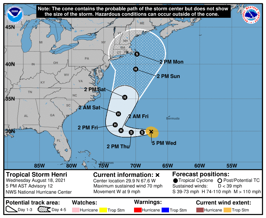
Getting closer and closer to the 40/70 benchmark. ETA - Levi Cowan's take -
-
Despite the cloud cover and attempts at the sun trying to break through but not quite making it out, the temp has soared a bit more than I expected. So far the high here hit 87 but it's currently mostly cloudy, with a few breaks in the ceiling, and 86, with a disgusting dp of 77.
-
LOL I have been watching the track change further and further west before the N/NE direction change the past couple days. It was originally progged to do a tight loop around Bermuda and out to sea but each subsequent update has it moving more and more westward before making the turn. In any case, I've been getting on and off stratus this morning along with the general overcast. Low this morning was 74 and it's currently 77, with dp 75.
-
Getting some light rain coming up from the south. It just reached the level to be enough to tip the bucket with 0.01" after wetting the walks. Temp is currently 79 with dp 74.