

Hurricane Agnes
-
Posts
9,264 -
Joined
Content Type
Profiles
Blogs
Forums
American Weather
Media Demo
Store
Gallery
Everything posted by Hurricane Agnes
-
E PA/NJ/ DE Winter 2021-22 OBS Thread
Hurricane Agnes replied to JTA66's topic in Philadelphia Region
Ended up with a high of 24 today, but that came at MIDNIGHT, so definitely had some CAA that oozed in! My "daytime" high was around 22. Currently 19 and clear, the winds have died down a lot and are closing in on calm, and have a dp that has finally moved up to 5. -
E PA/NJ/ DE Winter 2021-22 OBS Thread
Hurricane Agnes replied to JTA66's topic in Philadelphia Region
ICON is too (ETA although doing a hoochie dance by NJ). -
Thank you - I was living in a high-rise apartment at the time and didn't have garage access then for my car, so it was out in the lot. I was just happy to have parked in the perfect spot in the lot (on the SW side of the building), where the building blocked most of the snow from drifting along that side. And since it was so powdery (I remember in this area, the temps were in the low 20s through the 2-day duration of the event), probably 95% of it had blown right off my car, and I only had some powder on the front bumper that I brushed off in a few minutes. People parked on the other side had their cars buried. It was all over by my birthday (sunny and cold like today), when I finally emerged to do the "french toast run" (milk, bread, eggs) that I laughed off about doing before the storm. Luckily I was a couple blocks from the supermarket and rolled my portable shopping cart down the middle of the street, with 6 foot banks of snow on each side, having to navigate around a car that was abandoned and buried right where it stalled out on the street after the driver was unable to get it out. Thank you!!! I read the thread where he trolled Paul and Paul was being generous in time and patience researching the data to address what devolved into OTT nonsense being spewed about some of the old snow reports by a long-time spotter in Chester County. At that point, the trollery had already escalated into complete idiocy.
-
E PA/NJ/ DE Winter 2021-22 OBS Thread
Hurricane Agnes replied to JTA66's topic in Philadelphia Region
Well my my dp "untorched" and it is down to a -0.4 (tenths of an increment - edit, now down to a -0.6). But the temp finally made it "up to" 20 with full sun and all blue skies. -
E PA/NJ/ DE Winter 2021-22 OBS Thread
Hurricane Agnes replied to JTA66's topic in Philadelphia Region
Looks like I *might have* bottomed out at 16 this morning about 15 minutes after sunrise but I am still hanging around the upper teens and am currently at 17. However the dp is now "torching" and has "shot up to" 3F. -
E PA/NJ/ DE Winter 2021-22 OBS Thread
Hurricane Agnes replied to JTA66's topic in Philadelphia Region
GFS is hoochie mama's sugar daddy for sure. Still honking on that. As of 4:30 this morning, I was down to 18 with a dp of 0. It sucked the water out of my humidifiers overnight real quick so had to get them refilled again when I got up this morning. -
Thanks Paul! Glad to be back on the "green end" of a decade vs the "red end" of one.
-
E PA/NJ/ DE Winter 2021-22 OBS Thread
Hurricane Agnes replied to JTA66's topic in Philadelphia Region
Well now that was your mistake right there. I bottomed out at 27 this morning, and it's currently partly cloudy, bopping between 29/30, with a dp of 14, and sporting an active breeze. Also registered 0.30" in the bucket yesterday although I know some was probably a bit of snow melt. -
E PA/NJ/ DE Winter 2021-22 OBS Thread
Hurricane Agnes replied to JTA66's topic in Philadelphia Region
Temps and dps have slowly dropped overnight and I finally went below 32 not along after 4 am. Ended up with a final high of 40 after 8:15 last night). About 95% of the snowpack is gone save for a few patches here and there (particularly in the north-facing areas) and from some depleted mounds of plowed snow. Currently clear and 31 with dp down to 16. -
Thank you - I have read your historical background posts and appreciated your check-ins. And yeah, just getting started with the creaks.
-
E PA/NJ/ DE Winter 2021-22 OBS Thread
Hurricane Agnes replied to JTA66's topic in Philadelphia Region
When you are sledding on an ice-rutted street with potholes, the rails are the best way to do it because they won't get shredded like a tube. Tubes would be good on steep grassy slopes that are packed with snow or are useful going down piles of steps (they do that down at the Art Museum on those front entrance "Rocky steps"). Still there's nothing like an old-fashioned wooden sled with a rope to hang onto and (try to) steer the thing with. -
E PA/NJ/ DE Winter 2021-22 OBS Thread
Hurricane Agnes replied to JTA66's topic in Philadelphia Region
Ahh yes... And those times were very rare. We were a couple doors down from a lightly trafficked residential 1-way intersecting street that was on a hill and was perfect for the Radio Flyers when there were those rare times the street had a glacial ice base under some newly fallen snow. The only drawback was if there were huge plowed mounds at the bottom from the plow trucks that you slammed into if you didn't leap off in time. -
E PA/NJ/ DE Winter 2021-22 OBS Thread
Hurricane Agnes replied to JTA66's topic in Philadelphia Region
I just looked out and my 4.5" is all but disintegrated except for some shoveled mounds and patches here and there in open grassy areas. Temp is STILL going up and I am now at 40 (low was at midnight @25). Still getting some light rain although the back edge of that is getting close. -
Thank you. Do know that you are most appreciated here. I am always supportive of your office. I was a fed for 32 years before retiring almost 5 years ago and know first hand, about the abuse that feds often get thrown at them. We were, are, and always will be "regular folk" who have a mission of public service. Thank you. Starting to get more and more creaky nowadays. I know this is RedSky's fave -->
-
Thank you. And that stuff has some kick.
-
Thank you. I should get me some of that PA Dutch Eggnog that I have left in the fridge.
-
Thank you. As my BIL always quips - glad to be "upright".
-
Sunday Morning Ice Event - January 9th
Hurricane Agnes replied to ChescoWx's topic in Philadelphia Region
My temps have continued to creep up and am currently at 39 with some windswept light rain here and there, and dp 38. About 3/4 of the snowpack is gone, but then since it was such a dry snow, that was to be expected. -
I will 3rd that!
-
Thanks much!
-
Thank you. Thank you guys too! Best birthday present. A troll be in timeout.
-
Today is my 60th birthday. I could be your mother but am thankfully not. You need to be on a time out.
-
Sunday Morning Ice Event - January 9th
Hurricane Agnes replied to ChescoWx's topic in Philadelphia Region
Apparently an Accuweather met tweeted out a 0.25" accretion out their way near State College.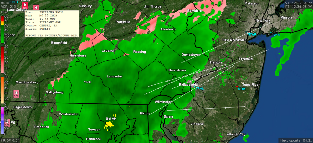
-
Sunday Morning Ice Event - January 9th
Hurricane Agnes replied to ChescoWx's topic in Philadelphia Region
That possibility was there but apparently didn't happen on this side of the state. I was concerned that even with above freezing temps, the ground was so cold that rain would freeze on contact but at least where I am, the precip held off until the past couple hours or so. -
Sunday Morning Ice Event - January 9th
Hurricane Agnes replied to ChescoWx's topic in Philadelphia Region
When that arctic front comes through, everything wet is going to flash freeze!


