Hurricane Agnes
-
Posts
9,344 -
Joined
Content Type
Profiles
Blogs
Forums
American Weather
Media Demo
Store
Gallery
Everything posted by Hurricane Agnes
-
E PA/NJ/ DE Winter 2021-22 OBS Thread
Hurricane Agnes replied to JTA66's topic in Philadelphia Region
I'm down to 19. dp 8. -
E PA/NJ/ DE Winter 2021-22 OBS Thread
Hurricane Agnes replied to JTA66's topic in Philadelphia Region
Made it up to 26 today as a high with the temps on the way back down now being a couple minutes after sunset. The snow on the south and west-facing house roofs is gone now (the north & east-facing still have some coating of snow). Currently 24 with some scattered clouds,. and dp 7. -
E PA/NJ/ DE Winter 2021-22 OBS Thread
Hurricane Agnes replied to JTA66's topic in Philadelphia Region
I bottomed out at 15 this morning and it is now sunny, a bit breezy, and up to 18 here, with dp 5. -
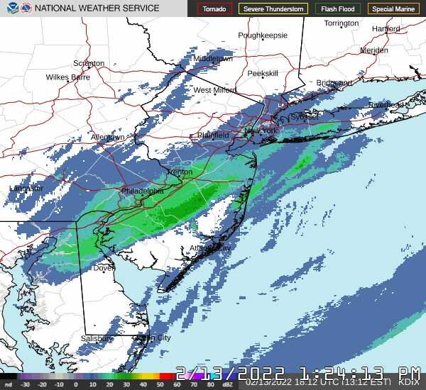
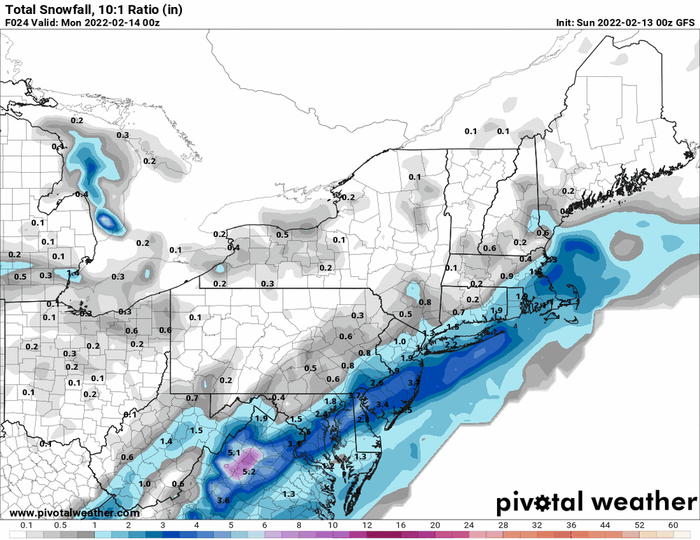
I stayed at or above freezing almost the entire duration of the event where I am (32/33) except for the very end. At onset here, it was drizzle that eventually changed to white rain and then a rain/snow mix for awhile before finally changing over to mostly light snow. The liquid component wasn't enough to tip the bucket here with the marginal temps. So I would expect further south in the city (I am about 20 miles north of KPHL) they may have had a much longer period of rain and "warmer" temps (e.g., 34 or higher) than I had where I am. In fact, the obs at the airport are here, although that page will be continually updating (Center City is about 5 - 6 miles from KPHL and I tried to format to mainly show the temps/dews and the 6hr min/max) - https://w1.weather.gov/data/obhistory/KPHL.html D a t e Time(est) Wind(mph) Vis.(mi.) Weather Sky Cond. Temperature (ºF) 13 23:54 N 10 10.00 Partly Cloudy FEW027 SCT065 29 15 13 22:54 N 14 10.00 Overcast SCT027 OVC060 30 19 13 21:54 N 10 10.00 Overcast OVC045 31 19 13 20:54 N 15 G 22 10.00 Overcast OVC028 31 21 13 19:54 N 14 10.00 Overcast BKN027 OVC031 32 21 13 18:54 N 8 8.00 Overcast SCT015 OVC028 33 24 35 / 33 (6hr) 13 17:54 N 10 8.00 Overcast SCT015 OVC028 33 25 13 16:54 N 12 4.00 Light Snow Fog/Mist BKN015 OVC025 33 27 13 15:54 NW 16 1.25 Light Snow Fog/Mist BKN008 OVC012 33 29 13 14:54 NE 3 1.50 Light Snow Fog/Mist BKN008 BKN011 OVC015 34 31 13 13:54 NE 5 1.00 Light Snow Fog/Mist BKN006 BKN015 OVC034 35 32 13 12:54 Vrbl 6 2.00 Light Snow Fog/Mist BKN007 OVC015 35 31 36/35 (6hr) 13 11:54 NE 3 2.00 Light Snow Fog/Mist SCT008 BKN012 OVC034 35 32 13 10:54 NE 5 1.50 Light Snow Fog/Mist SCT007 BKN011 OVC029 35 31 13 09:54 Calm 1.75 Light Snow Fog/Mist BKN008 OVC014 35 31 13 08:54 NE 3 8.00 Light Snow BKN011 BKN018 OVC070 35 31 13 07:54 N 6 3.00 Light Snow Fog/Mist BKN006 BKN011 OVC070 35 31 13 06:54 NE 5 3.00 Light Snow Fog/Mist BKN014 OVC031 35 31 40/35 (6hr) 13 05:54 NE 5 5.00 Light Snow Fog/Mist FEW012 OVC060 35 31 13 04:54 N 8 7.00 Light Snow Snow Pellets FEW012 OVC055 35 30 13 03:54 Calm 7.00 Light Snow OVC055 36 30 13 02:54 Calm 8.00 Light Snow OVC049 36 31 13 01:54 Calm 7.00 Light Snow SCT028 OVC047 37 29 13 00:54 N 16 G 21 10.00 Light Rain OVC043 40 28 52/40 (6hr) So with the ground temps also warmer down there given the antecedent days of warmth (the high on 2/11 was 62 and on 2/12 was 60 where mine were 59 and 57 respectively), it would be difficult to accumulate until the ground cooled enough to reduce the melting.
-
Looks to be pretty much done here now and temp is now 30 with dp starting to drop, and at 26. Finished up with 2.01" (compacted).
-
Nice view! Northampton County for sure came out on top for this storm. I finally made it below 32 sometime before 3:30 pm. Still getting some SN- and one more measure and clear yielded another 1/8" to get to 2.01". Currently 31 with dp 29.
-
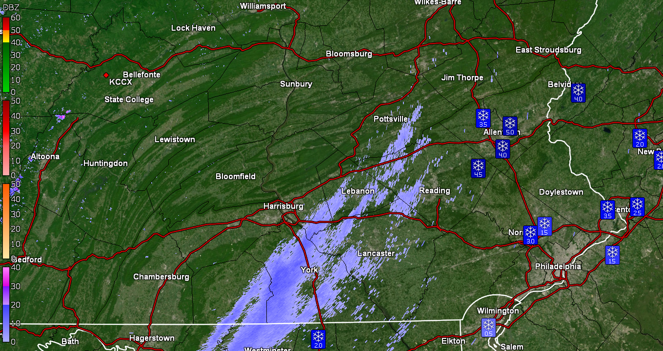
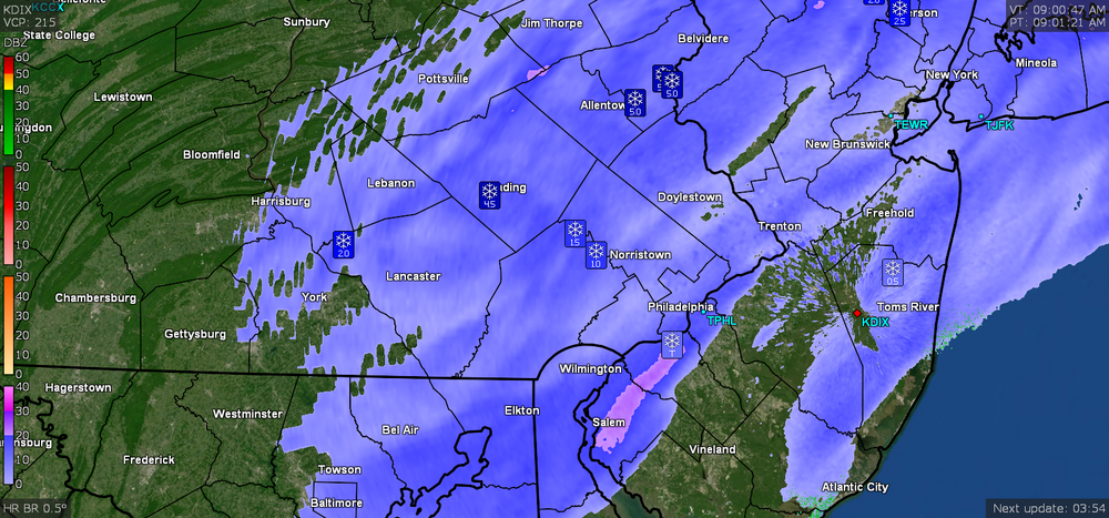
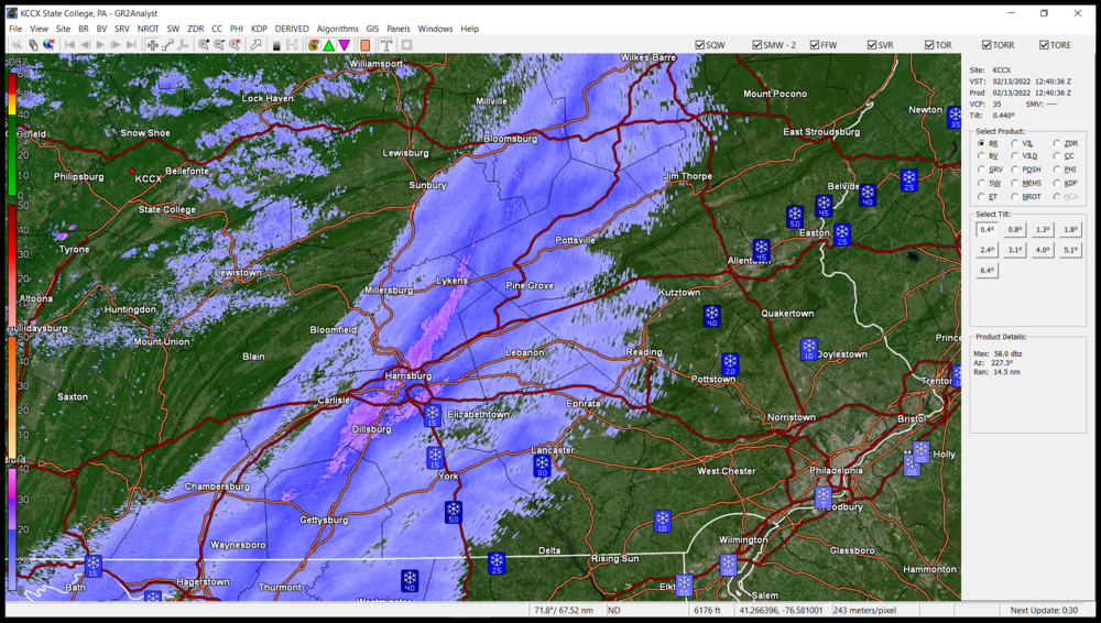
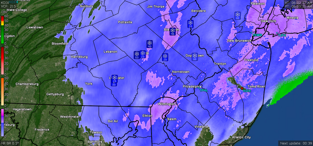
Still have some SN- with finer flakes again and temp bopping between 32/33 and with dp 30/31 (still have not gone below freezing for this event so far, so melting continues on warmer/treated surfaces). Did another measure and clear for an additional 1/4" for 1.88" total so far. The band in central PA (from KCCX radar) finally appears to be thinning, so the western edge of what is really a broader "firehose" than what KDIX is showing, is starting to break up.

-
Currently SN with bigger flakes but still above freezing at 33 with dp 31. I had partially cleared the board and with the slightly fluffier snow, have an additional 1/8" (even with the melting). So with the earlier 1.5", now have 1.63" (compacted).
-
Still at or above freezing here and currently 33 with dp 31 and light snow continuing, but also a lot of melting. Have been watching the accumulations on my car literally sloughing off.
-
There's a little enhanced band over Salem and Gloucester counties in Jersey... Hopefully someone from there has any reports. Just measured again and am up to 1.5" with melting/compaction and still getting some light snow but am at 33 with dp 31.
-
Latest PNS issued (8:19 am) -
-
There are now a bunch of 6 inch reports (spotter and "public") in Northampton County. You have to look at KCCX and the band back west. It has been pretty much sitting over that area so I don't know how far west it will go but I guess it depends on what the jet does... Am currently "up to" 33 with dp 31 and light snow (but also dripping).
-
If you look west to State College CWA, there is a whole band back that way and if any of it survives to move east intact, then there would be more. Currently still holding at 32 with dp 31, but have all fine-flaked snow at the moment (no mix that I can detect).
-
Went out to get a measurement off the board and have 1.25" (wet/compacted) at post time. ETA to add Mt. Holly's latest note (but still too low for further north based on current obs up there) - Not sure when it will eventually happen but the digging trough/jet apparently didn't "dig" as deep as progged (at least for this time frame) to bring the cold air in further south for the precip to accumulate in the I-95 corridor as much as it has north of I-78. ETA2 - I'm not sure of what the WSW criteria is upstate but I think ours down here is at least 6" and they are getting close to that north of I-78... and if the criteria is the same, then they might warrant a WSW in the LV.
-
Currently still holding at 32 with dp 30. Still getting an alternating drizzle/flurries mix or just SN- with not much accumulation on top of what is there, since melting is going on. Looks like the I-78 - I-80 corridor cashed in (so far). Various Berks Co reports of 4" - 5+" (ETA - just saw Newman's post above).
-
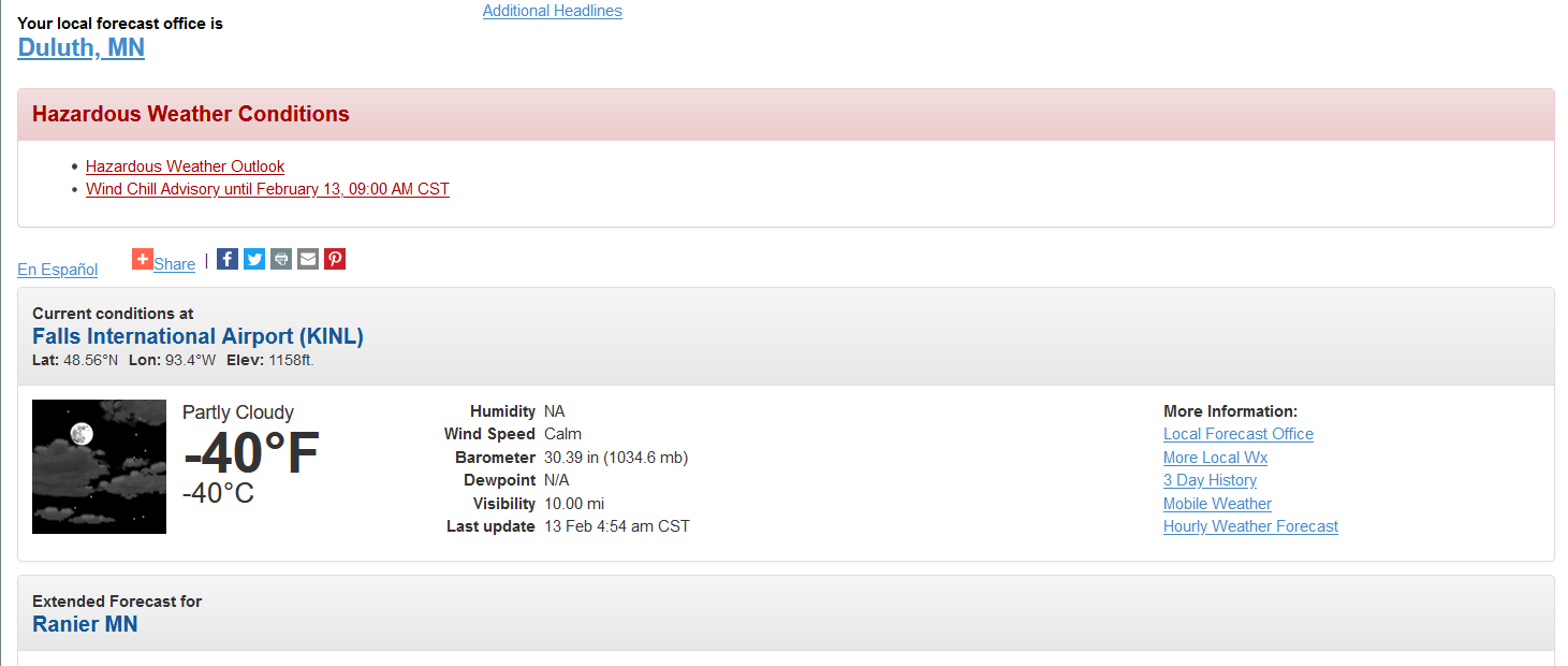
Just as an interesting side issue regarding the arctic cold, here is what is going on in Duluth, MN CWA (vs SoCal) -

-
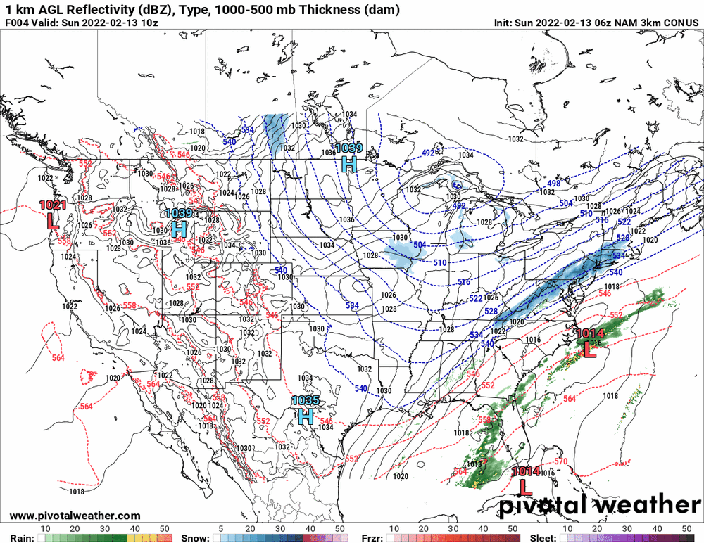
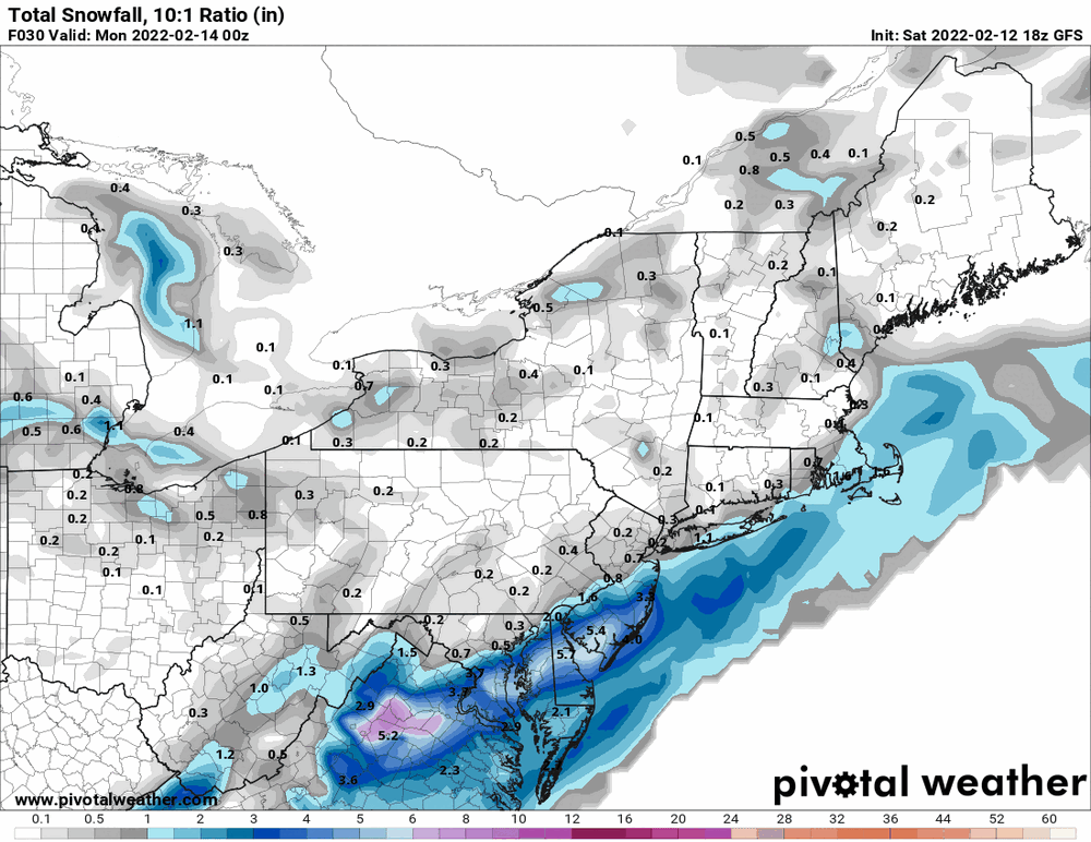
Looks like that 0z NAM had the right idea last night but the bullseye zone was shifted well to the NW probably due to the temps. Current for where it thinks things are and progged snow (still low-balling LV stripe).
-
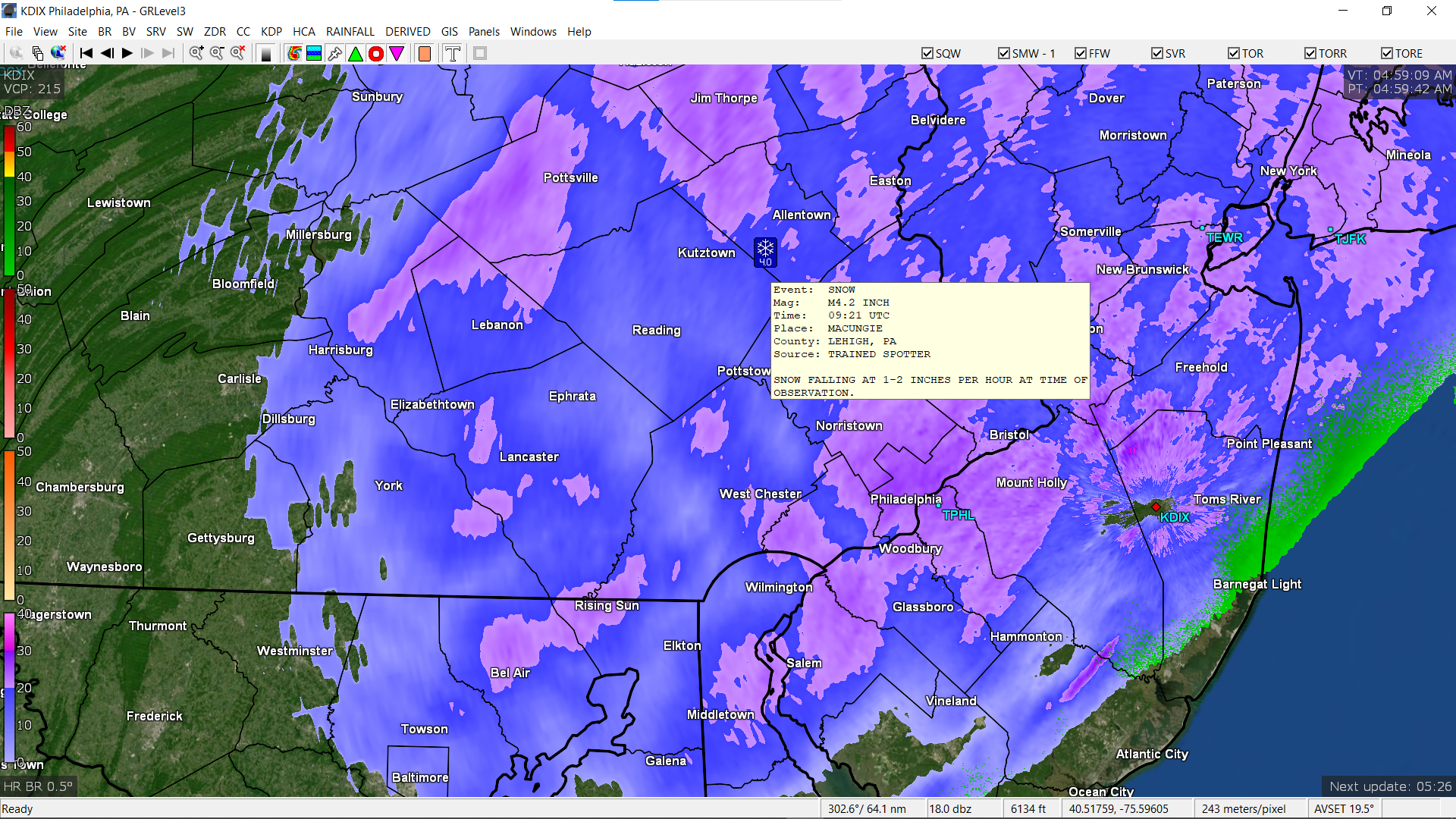
Trained spotter listing 4.2" up in Macungie.

-
Have about 1/4" coating on cold surfaces (cars and grassy areas) here but am getting white rain and/or rain/snow mix. Temp is right at 32 with dp 31.
-
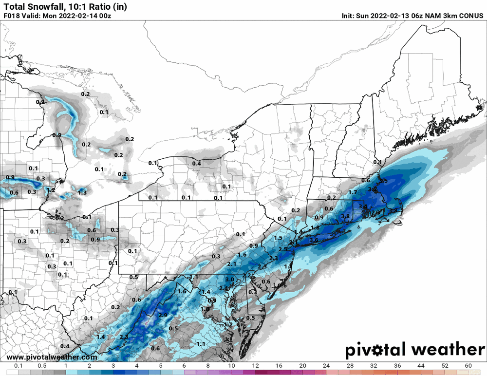
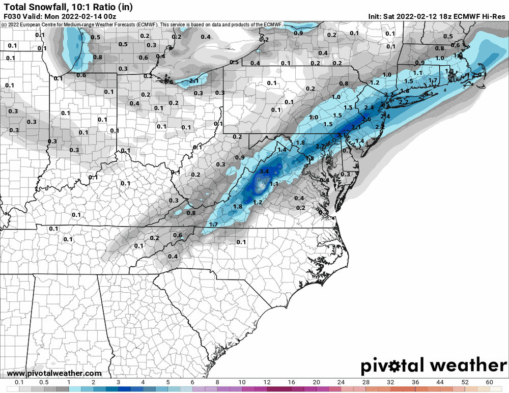
Based on the last few runs, that is WAY "north" from where it was before! Basically it caved to Euro. 18z Euro and new 0z NAM (that tempered itself somewhat) below...
-
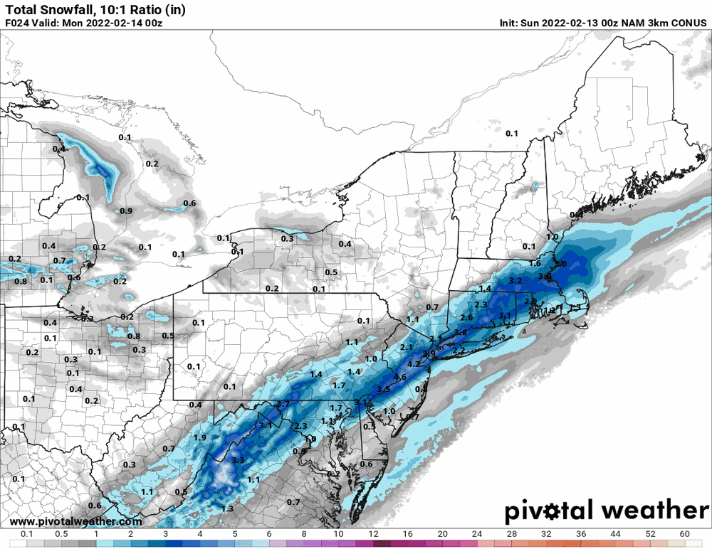
0z GFS has been running and has upped the I95 corridor amount compared to the 18z (although reducing the S. Jersey lollies). Currently down to 41 with dp 25. ETA - there are radar returns right over me but I confirmed it's nothing but virga at the moment...
-
Currently down to 42 here with dp 26. Radar is showing some scattered returns...
-
18z GFS did something interesting - although it's still scant N/W of I-95, it jackpots S. Jersey and Delaware (more than any of the models including the NAM)!
-
E PA/NJ/ DE Winter 2021-22 OBS Thread
Hurricane Agnes replied to JTA66's topic in Philadelphia Region
Ended up hitting 57 today after a low of 43 and it's currently 52 and partly cloudy with dp 30. -
Latest from Mt. Holly for forecast snow -