

TheClimateChanger
-
Posts
3,595 -
Joined
-
Last visited
Content Type
Profiles
Blogs
Forums
American Weather
Media Demo
Store
Gallery
Posts posted by TheClimateChanger
-
-
1 hour ago, TimB said:
It appears our spring average temperature got to 56.7, which puts us in sole possession of first place for warmest spring ever in the threaded record.
Yes, warmest and second wettest meteorological spring on record.
-
52 minutes ago, roardog said:
What is the source for this information? I'd like to read about it.
It was a passage I had found in a 19th century US climate book, quoting a person who witnessed it.
-
4 hours ago, Stormchaserchuck1 said:
Actually, just speaking from personal observation, it's the Sun.
Does higher CO2 deplete the ozone to make the sun shine brighter to ground heat?
Here's my little climate tidbit of the day. We can't even imagine how cold it used to be. There was so much ice in the upper lakes following the absolutely frigid winter and spring of 1836-1837, that the Saint Clair River closed to navigation in June as it was flowing downstream.
QuoteOn June 1, 1837, the St. Clair River between Lake Huron and Lake Saint Clair closed up with ice. The schooner New York became caught in the ice at Recors Point and was carried downstream. In the same year, ice was harvested from the river until July 4th.
-
On June 1, 1837, the St. Clair River between Lake Huron and Lake Saint Clair closed up with ice. The schooner New York became caught in the ice at Recors Point and was carried downstream. In the same year, ice was harvested from the river until July 4th.
-
2 hours ago, ChescoWx said:
Sorry to the climate alarmists on this site.....you won't appreciate this info.....but only 4% of USHCN stations have reached 80°F so far this year, which year-to-date, is fourth lowest on record since 1895 behind 2011, 1995 and 1935, and is about the same was 1924. The peak year was not surprisingly 1934. The top five years are 1934, 1936, 1969, 1939 and 1914.
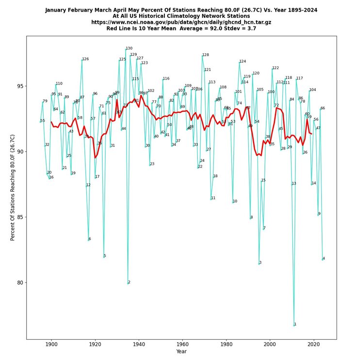
First of all, the digits are Tony's rankings, not percentages. In fact, it looks like 82-83 percent of stations have reached 80F. But more importantly, this is a meaningless statistic for a number of reasons. It's affected by the average elevation, latitude, urban character, etc. of the station mix. If there's a higher percentage of stations in high latitudes and/or higher elevations, you would expect a lower percentage to have recorded an 80F day before the end of May [also, I doubt all of May 2024 has been included in the data -- the month is just now ending]. Further, it's affected by equipment changes. It's well established that a lot of the automated stations report somewhat lower maxima than traditional LiG thermometers housed in a shelter.
Even ignoring all this, it's not really meaningful. It looks like pretty much every year at least 80 percent of stations have reached 80F by May 31. There's only about 15 percent or so of stations that vary in a given year - many of which are probably in the same general area [somewhere in the northern US]. Many of these places probably don't see 80+ until late in the spring, so all it would take is a cool spell in May to keep them from reaching that temperature. Meanwhile, the rest of the country could be baking... and even the places that fail to reach 80F might have been way above normal for the majority of the year.
-
5 minutes ago, Bubbler86 said:
I said it in reference to the forecaster who almost always taints toward being warm. Look back to 2021 when both June and Aug were over 3AN at MDT. 5 of the top 8 warmest summers are over the last 10 years and are warmer than MU's forecast. For this year Take a +1 in 2 months and a +4 in one and that is a +6, which is near or below all of the 5 summers referenced above. It is not cool of course but norm for the new reality.

Oh we’re you saying “too long, didn’t read” - I thought it was some sort of city or county abbreviation but couldn’t figure out what it could possibly be.

-
4 hours ago, Bubbler86 said:
That is not too bad actually.
What? I don’t know what TL or DR means, but those monthly anomalies would result in one of the hottest summers on record surely.
-
1 minute ago, bluewave said:
A new paper seems to back up the idea that the abrupt reduction marine aerosols is accelerating the warming rate.
https://www.nature.com/articles/s43247-024-01442-3#Fig2
Abrupt reduction in shipping emission as an inadvertent geoengineering termination shock produces substantial radiative warming
Human activities affect the Earth’s climate through modifying the composition of the atmosphere, which then creates radiative forcing that drives climate change. The warming effect of anthropogenic greenhouse gases has been partially balanced by the cooling effect of anthropogenic aerosols. In 2020, fuel regulations abruptly reduced the emission of sulfur dioxide from international shipping by about 80% and created an inadvertent geoengineering termination shock with global impact. Here we estimate the regulation leads to a radiative forcing of Wm−2averaged over the global ocean. The amount of radiative forcing could lead to a doubling (or more) of the warming rate in the 2020 s compared with the rate since 1980 with strong spatiotemporal heterogeneity. The warming effect is consistent with the recent observed strong warming in 2023 and expected to make the 2020 s anomalously warm. The forcing is equivalent in magnitude to 80% of the measured increase in planetary heat uptake since 2020. The radiative forcing also has strong hemispheric contrast, which has important implications for precipitation pattern changes. Our result suggests marine cloud brightening may be a viable geoengineering method in temporarily cooling the climate that has its unique challenges due to inherent spatiotemporal heterogeneity.-
 1
1
-
-
22 hours ago, GaWx said:
I'm remaining open-minded about how much of the excess heat since 2023 can be connected to Hunga Tonga since it still hasn't been explained. The atmosphere is way too complex and Hunga Tonga was quite unique with regard to the volume of water vapor added to the stratosphere,
-
1
-
-
-
9 hours ago, roardog said:
I’ve read some dumb stuff online in the last 25 years or so that I’ve had access to the internet. I have to say though, that missile strikes on foreign fossil fuel assets to combat climate change might be the dumbest. Maybe the western pacific warm pool would diminish with nuclear winter. lol
I must have missed all the nukes flying when the NordStream 2 blew itself up.

-
1
-
-
-
Overall, an interesting post. Had to truncate the end due to lack of upload space. Must say I'm not sure what all the relevance to Trump is, some of these people just can't post anything without blabbing out Trump. Apparently, a Mormon Mitt, Nimrata Randhawa Haley, Dick-less Cheney, "Dubya" or Ronnie Reagan Republican party would have been so much better.

-
5 hours ago, ChescoWx said:
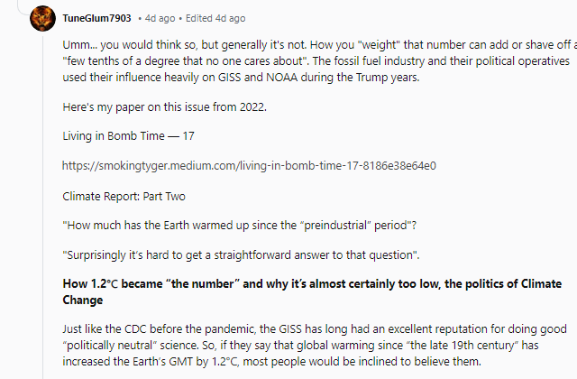
LOL!! you must have misread that article as it further supports the fact that man keeps chilling the past in this case with "tree ring data" to amplify the current warmer cycle.
Umm, no. Retaining the tree rings for that era makes the warming more pronounced. But even the very selection of start date was carefully crafted to minimize the warming. Take a look at this interesting Reddit post from user u/TuneGlum7903:
-
3 minutes ago, FPizz said:
That would send the world into a war, ending the world way faster than a few degrees warming.
It's more about projecting strength than anything. Sometimes the carrot on the stick doesn't work, and you have to be a little more aggressive.
-
31 minutes ago, AdMC said:
Hey guys while you squabble about whether or not climate change is real, the world is on fire...we need to be solutions oriented at this point. The ship has sailed on trying to convince the deniers. Maybe let's create a new subforum about climate change solutions.
At this point we'll need to come up with and implement geoengineering solutions to bring down the heat imbalance every square meter that our planet is experiencing. Direct air carbon capture can work over longer time scales with enough GDP dedicated to the effort, but it will not break the fever so to speak. Lastly, full electrification of every possible activity is essential.
If you are a denier and want to dismiss this, I absolutely could not give a rats a$$, it is not for you. The debate was over decades ago.
Everyone else, stop letting them live rent-free in your head. They don't argue in good faith, and only serve to slow your efforts which again, should be solutions oriented.
Thank you -
Hi @AdMC, this was my advice to President Trump several years ago:
QuoteThis is one area I think Trump can do better. I really thought once he received a full intelligence briefing on the matter, he would act swiftly to prevent catastrophic climate change. I don’t know how familiar you are with the concept of near-term human extinction resulting primarily from climate changes, but amplified by myriad other environmental stressors. Long story short, we have precious little time to act as we are facing a catastrophe that could ultimately lead to a total societal collapse, if not outright human extinction (though perhaps a small population of humans could survive the cataclysm).
I know a lot of us were taken by the swift talking of former President Obama when he promised in his initial inaugural address to reverse the climb of the Oceans. Obviously, the opposite happened during his eight year term with rates of sea level rise not slowing, but accelerating. With that said, I place the bulk of the blame on the predominant neoliberal politico-economic regime that has spread in the post WW-2 era. Some of the blame, of course, lies directly on our complex, industrialized society (irrespective of politico-economics). But this is amplified greatly by the globalization of society that has wreaked havoc on our county.
Instead of locally sourcing our goods, we are shipping them over in massive container ships spewing unbelievable amounts of carbon! The global elites jet set around the world, thumbing their noses at those they perceive to be lesser than themselves. This to the tune of hundreds of thousands of flights daily, spewing unimaginable quantities of carbon dioxide and other greenhouse gases. This same elite of rootless cosmopolitans (as Stalin put it) just cannot whet their appetite for travel as evidenced by the massive fleets of gigantic cruise ships sailing the ocean blue, again spewing unimaginable quantities of carbon into our precious atmosphere.
Compounding things, this globalized society hasn’t even benefited the average American. Instead, it’s made life miserable for the average American. Factories out of business, replaced with mindless service sector jobs that pay a fraction of the wages of the jobs being replaced. All the while our goods are produced by a new generation of slave labor in far off places that most Americans have never even heard of. And then shipped here in the method described in the previous paragraph. It’s a travesty!
I would put an end to globalization, with a phase out of all transnational flights (replaced with carbon-free airship/dirigible travel). I would move production back to America, and invest in a green new deal to phase out all fossil fuel and nuclear energy generation in as short a time as feasible. In addition, would invest greatly in modernizing our public transportation sector and make our highways as friendly to electric vehicle traffic with a goal to phase out they gasoline/diesel combustion engine in the next decade.
To accomplish this, I would nationalize all assets of fossil fuel companies in the US - including both domestic companies, as well as American assets of foreign corporations. In addition. I would cancel all loans granted by banking institutions to these fossil fuel companies so the assets would be taken free and clear of any existing liens. So this would include trillions of dollars of land and mineral rights - as well as equipment and machinery, intellectual property, etc. Honestly, with those resources, you might be able to get a feasible means of carbon capture and sequestration.
Additionally, I would enter into global agreements authorizing deployment of stratospheric aerosols delivered via military aircraft to cause an immediate drop in surface air temperature. These aerosols would be injected into the stratosphere mimicking the effects of volcanic activity and buying us needed time to address the ongoing climate catastrophe.
Finally, I would keep on the table the option of tactical missile strikes on foreign fossil fuel assets. We cannot allow China and India to continue building countless coal plants - not in 2020! We have already exceeded the carbon budget to ensure a livable climate for future generations. We need strong, powerful leadership that isn’t afraid to take real action to preserve a livable climate.
I think completion of the wall is a good thing as well, since many projections show the potential for tens, possibly hundreds, of millions of climate refugees. This will exceed our ability to maintain order especially in light of the increasing climate calamities we will be facing. A well secured border will be essential in an increasingly nationalized, localized and deglobalized world as the whole Ponzi scheme spirals out of control.
-
1
-
-
4 minutes ago, TheClimateChanger said:
More tired recycling of the same nonsense. When La Nina begins later this year, can we finally put this nonsense to bed?
I mean we are almost 2 1/2 years from that eruption. How many more years are these people going to attempt to attribute the global heat wave to that volcano?
-
2
-
-
12 minutes ago, GaWx said:
This same paper was put out in Aug of 2023 as per my 8/9/23 post quoted above. It appears the same one was just re-released on 5/27/24 and that's what Ryan is referring to. So, although Ryan refers to this as new, he doesn't realize it was first released 8 months ago.
It is an interesting paper as it suggests that the significant effects may last til 2030 as Ryan says.
Looking ahead to the possible effects on US winters 2025-6 through 2028-9 from the January of 2022 Tonga volcano, the chance of a multiyear El Niño MAY be enhanced while the volcano still has influence. Note how the DJF temperature anomaly pattern over the US comes rather close to a typical El Niño, including the cool SE and warm NW. Also, note especially figure 11d (see my link to August 2023 paper), which shows an El Ninolike Pacific SSTa pattern.
From the paper:
"Thus, it is possible that the SWV forcing from the eruption would favor a positive phase of ENSO on a multi-year timescale, but further work is required to confirm this, in particular with a model including fully interactive ocean and cloud feedbacks."
More tired recycling of the same nonsense. When La Nina begins later this year, can we finally put this nonsense to bed?
-
Interesting link I found on reddit [r/minnesota]. It's a report from the Minnesota DNR about the state of the climate, which was just released a few days. This is a Google Drive link to a powerpoint presentation made by the DNR, which is not available elsewhere.
Link: State of Climate_MN_May24.pdf - Google Drive
-
3 hours ago, TheClimateChanger said:
Looks like you were right @ChescoWx, they are lying about the temperature increase. Just in the opposite direction that you claim.
-
-
3 minutes ago, TheClimateChanger said:
To be honest, I don't really trust Chesco's weather data. With all the outlandish things he posts, it would be very easy for someone of his predilections to manipulate the data to show less warming. Holding a block of ice under the sensor on a couple of mornings each month to produce spuriously cool data, and gradually increasing the frequency of such manipulations, could largely erase the warming trend.
I know, in the past, he has admitted these temperatures were measured from different devices over time. Now he claims the same equipment has been in place for two decades.
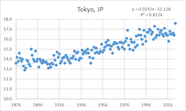
Perhaps somewhat surprisingly, based on the chart you shared, his data seems legit. But if it starts to deviate substantially from NOAA, I'm not going to believe him that there is a conspiracy to produce warming, I'm going to assume he is manipulating his readings.
-
12 minutes ago, chubbs said:
No, you aren't posting any actual data. Your county "average" skews the actual data by not accounting for changes in station mix. Here's some actual data - your own house is warming faster than NOAA. Are you altering temperatures? or perhaps you have a heat island in your backyard.

To be honest, I don't really trust Chesco's weather data. With all the outlandish things he posts, it would be very easy for someone of his predilections to manipulate the data to show less warming. Holding a block of ice under the sensor on a couple of mornings each month to produce spuriously cool data, and gradually increasing the frequency of such manipulations, could largely erase the warming trend.
I know, in the past, he has admitted these temperatures were measured from different devices over time. Now he claims the same equipment has been in place for two decades.
-
1
-
-
10 minutes ago, TheClimateChanger said:
Regardless, we can make a big hullabaloo over some adjustments to the recent record due to a site change. Or we can look at the bigger picture, and see an alarming warming trend of 2.4 degrees Celsius per century dating back to the 19th century.
Just for the record, this is the actual raw, unadjusted data. Nice of Tony to stop his analysis in 2021, but 2023 was warmest of record even with no adjustment for the recent site change. 2024 is shaping up to be the same. The reality is the adjustment looks substantial with two cherrypicked dates over a short timeframe but would almost certainly be negligible over the whole period of record. That's why he doesn't show the whole period of record.


Extended summer stormlover74 future snow hole banter thread 23
in New York City Metro
Posted
Wonder what they’ll blame this one on? I remember last summer when they showing up in the north, the experts were blaming it on some tropical storm.