

TheClimateChanger
-
Posts
1,882 -
Joined
-
Last visited
Content Type
Profiles
Blogs
Forums
American Weather
Media Demo
Store
Gallery
Posts posted by TheClimateChanger
-
-
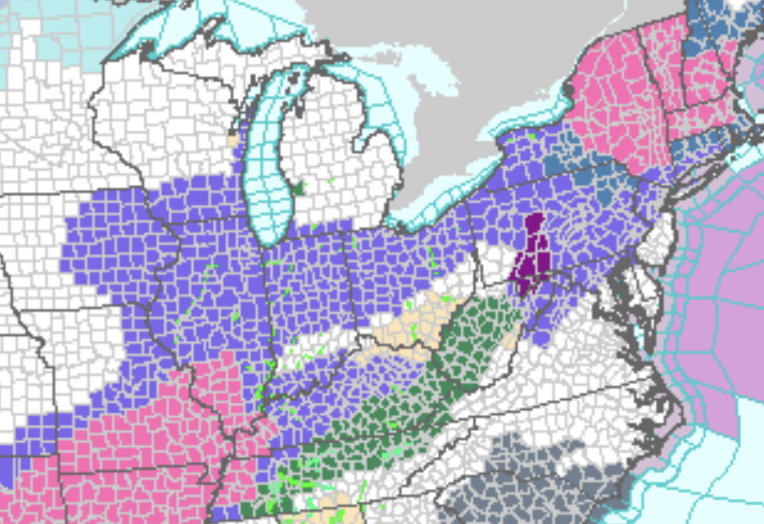
00z UKMET finally got a clue. This is with 10:1 ratios since Pivotal doesn't have a Kuchera map, but ratios should be more like 15:1. So you can increase these totals by about 50% to make it match the other Kuchera maps. Even so, now brings 4-6 inches from southern Washington, Greene, Fayette, Westmoreland, and 2-4 inches north. With ratios, would be more like 6-8 inches south and 3-5 inches north, which is now not too dissimilar to the other guidance.

-
2 minutes ago, PghPirates27 said:
I wonder where the water channel is pulling from. 1-3” tomorrow night then 1” or less Saturday. That’s 2-4” max.
Very glad to hear more agreement than usual on the models. Maybe that bodes we’ll for us here.Yeah, I just checked. They do have 1-4" (1-3" Fri. night and less than an inch Saturday) which is actually down from 2-6" earlier. The lower end of that range doesn't seem credible. I mean it could be right but I don't see any model support for less than 2" at all, the upper part of that range (3,4") isn't too far off from what I'm thinking (4,5" maybe 6" south).
-
If I were to make a call based on the current weight of guidance, I'd say 4-5" north of the city. There could be a bit more north of I-80 if some lake enhancement/lake effect were to occur. Looks like about 5" in the city and immediate 'burbs, with perhaps 6 inches down towards Elizabeth/Jefferson. A bit more south of I-70, with some 7 inch amounts possible in southern Washington, Greene and Fayette Counties. The Laurel Highlands look to have the best chance to see more than 7 inches of accumulation.
-
7 minutes ago, PghPirates27 said:
If I’m not mistaken GFS has been colder and had high snowfalls the last few storms and caves at the last minute. Seems to be the truth is in the middle so a 2-5” storm seems about right. I’ll take it at this point!
I hope it's not on the lower end of your range. The only model I've seen that low is the UK Met. But the UK Met looks to be off in la-la land compared to everything else. Even the Euro would support 3"+ areawide.
With the exception of the UK Met, I think there's actually much better model agreement with this than the typical storm. We're often looking at guidance showing 6"+ in places and other guidance showing rain/mix. The GFS and Canadian are showing around 7" in Pittsburgh. Most of the other shorter term guidance seems to be in the 4-5" range, maybe 6". Even the newly completed 03z RAP run, which I thought looked horrible, brings a solid 4-5" for most of the area with 6-7" in Greene and Fayette Counties.
-
The orientation on the 18Z NAM looks much more favorable than the earlier runs. Similar to Canadian models.
-
Looks like south and east is the place to be with this one. Big hit for Greene, Fayette, and Westmoreland Counties, as well as northern West Virginia.

-
Smelling the rain never works here because the warm tongue always wins out - if not at the surface, aloft. We do much better staying all snow and potentially exceeding forecasts when we're on the western fringe of a storm forecast to dump 12"+ in central PA. The precipitation shields often seem to expand further west or at least linger out this way longer than expected.
-
As always though, we are living on the edge. Snow totals rapidly decrease as you head northwest - although some of that may be because some snow fell in those areas before this 24 hour snapshot.
-
12Z NAM looking good. Below is the 24 hour total ending 00z Sunday. 8.7" of that falls in 6 hours between 12Z and 18Z Saturday. If this were to come to fruition, there would be no doubt as to whether it was warning criteria. I know that's often a point of contention.

-
About 2" here on grassy and elevated surfaces. Paved surfaces mostly just wet/slushy.
-
Wind is ripping downtown. Surprised there are no warnings.
-
1 hour ago, Ahoff said:
Just a weird phenomena.
I always figured that was just elevational effects mainly. PIT is at 1201', while SYR is 420' and BTV at 330'. There's usually not nearly as much of a north-south gradient in the summertime - in fact, many times with a big summertime ridge, there's warmer air aloft spreading in from Canada than there is further south. The moist adiabatic lapse rate is 3.5F per 1000 feet and dry adiabatic lapse rate is 5.4F per 1000 feet, but superadiabatic lapse rates can occur. Plus because of SYR and BTV's location, they get downsloping from most wind directions. PIT would only have downsloping from the east, otherwise generally a mild upslope flow (1200' being one of the higher points, which makes sense because it's an airport - there are a few 1300-1400' spots).
If you look at last year, PIT had 5 90+ days, while SYR had 18 and BTV 14. However, BGM at 1627' only had 2 such days. I imagine if records were still kept downtown at say 800 or 850 feet, there would be more. The hot Syracuse temperatures are always a point of contention with the locals here, but elevation effects alone suggest it should be 4-6 degrees cooler in an atmosphere with adiabatic lapse rates than nearby Binghamton. I would imagine subtle downsloping effects and a more urbanized environment could even enhance those numbers somewhat. Obviously, in the winter, these trends don't hold. Temperature inversions are common, and lapse rates lower even in the absence of a temperature inversion.
-
 2
2
-
-
1 hour ago, TimB said:
Hard to envision a scenario where winter isn’t over. We’ve currently had 1.6” from Feb 6 on. Outside of a couple years in the 1880s (which we all know I question the accuracy of), we’ve never had less than 3.6” from February 6 until the end of the snowfall season. Normally I’d say we can pick up 2” in March, but we’ve gotten barely half that the last two years combined and the pattern for this March doesn’t look good.
Surprised that they didn’t get any accumulations over the last couple days. We had at least a half inch, if not 3/4 of an inch in my backyard. Kind of surprised with the trace yesterday too, as there was certainly a light dusting near the airport which normally means .1 or .2 on the snow board.
-
48 minutes ago, TimB said:

Does this one even need words?
Meh, we're not really missing anything. Even north of I-80, it doesn't look like more than an inch or so. You have to be way up near the lakeshore in Erie for this event to maybe pick up a few inches (but anything over 3" there would probably have to come via lake enhancement/lake effect as the storm pulls away tomorrow). Most of those advisories are for a tenth or two tenths of icing, with only light snow/sleet accumulations. I'd actually prefer 33-36 and rain, over 30-33 with icing concerns. Western New York might do all right, but even there it looks like mainly 3-6 inches which is really nothing for that region.
-
28 minutes ago, PghPirates27 said:
I agree. Just like when there is a storm when it's close but we are on the rain side we get drenched but when it's cold enough for snow we get the dry slot lol. All I wanted this winter was 1 warning level event and we got that. Just stinks to waste a February.
Meanwhile OKC has thunder, snow and sleet with a temperature of 11 and windchill of -7.
-
22 hours ago, TimB said:
Look for those ice accumulations to go away over the next day or two as well. We’re going to waste yet another inch plus of February precipitation on plain rain.
Yes, doesn't look like this should be nearly as big of a deal as the early February event that caused a lot of power disruptions west of Pittsburgh. That one was kind of a unique event with the cold air pressing south. This event looks like it should be a more typical storm track with warm air surging northward. Still most of the models at this point in time would support at least a glaze of ice to perhaps a tenth of an inch or so north of the city. I know some of the ice accumulation maps show a lot more than that north and west of the City, but that's right around 32 so I wouldn't expect much accrual. Won't be 30/31 like in the early February event. Also should rise above freezing areawide at some point with just plain rain for several hours.
-
Well, it looks like the GFS has surrendered on the snowfall front. Still shows a modest snowfall north and west of the city, but the heaviest accumulations are well off to the north now. Regardless, looks like another precipitation bomb. So probably a good idea to keep an eye on this as their could be more significant ice accumulations for parts of the region. Looking at the temperatures shown on the GFS (probably underdone) but they keep it generally below freezing for the city (29-31) until the low approaches when it spikes into the low/mid 30s for a few hours, before dropping back into the 20s.

-
The GDPS looks a bit more realistic to me with its depiction

-
Turned sunny here, now a second squall popped up.
-
12 minutes ago, TimB said:
You’re in like Beaver, right? Where there was that nice area of yellow on the radar?
Yeah, that was showing up as 40 dbz on radar.
-
Surprised there’s no snow squall warning for this. How bad would it have to be to get one?
-
-
Quite squally here now.

-
Snow squall band looks to be training and setting up more parallel to the flow, rather than perpendicular to the flow. Maybe we can pick up an inch or so.


Western PA/Pittsburgh Winter 2021/22 Discussion
in Upstate New York/Pennsylvania
Posted
Still on the lower end, since even with ratios, would be just under 4 inches in the city center. But at least now it's more or less in line with the rest of the guidance. Which is why I said I think there's actually greater agreement than usual. With the UKMet more in line, it looks like the lowest guidance - RAP, Euro, UK - would still support about 4" or so in the city, with the highest guidance - GFS, Canadian - showing about 7" or so. That's a pretty tight spread, no?