TimB
-
Posts
17,206 -
Joined
Content Type
Profiles
Blogs
Forums
American Weather
Media Demo
Store
Gallery
Everything posted by TimB
-
 3k NAM is probably the ceiling for the Sunday event. Drops a clean 3” of all snow, but of course that’s still in the end of its range. NWS is carrying next to nothing and mostly rain. Is it over?
 -
Euro is still holding onto a scenario where it isn’t complete garbage and we get decent snow on the front end, but we all know the warm air always comes in way faster than modeled.
-
Can’t be any p-type issues if there’s no precip!
-
Sun’s out. Hopefully that brings the storms later.
-
Let’s get some good severe tonight that knocks out the power for several days so we don’t have to look at these progressively more depressing model runs.
-
CMC looks like it’s going to agree. Once again, it’s over.
-
CMC is even worse. Has the low center on the VA/NC line near the coast, then runs it up the coast and it’s raining in Pittsburgh.
-
Sun-Mon is almost workable on the GFS. Wed is a disaster.
-
The ensembles still look kind of acceptable, I guess.
-
Every single model that ran overnight continues our misery next week and proves that it was silly that we ever hoped for something good. Unreal.
-
I’d buy what the 18z GFS is selling. Sunday-Monday is a bust but Wednesday is a borderline advisory/warning level event and there’s another storm the following weekend, but that’s way too far out to make any judgments.
-
Euro is a winner with the Wednesday storm.
-
Pretty much certain that we’ll make it through Saturday without a 2” daily snowfall since last March, which would be 300 days without a 2” snowfall. This will be the 9th time this century (23 years, 9/23 = 39%). Prior to 2000, that occurred 16 times in 120 years (16/120 = 13%).
-
Anyhow, my bar for next week is set pretty low. 3-4” combined from the two storms would make me happy.
-
So advantage at 18z to a model that cuts both storms in a way that absolutely sucks for us and gives us less than an inch combined. I’m ready for more misery.
-
Euro gives us a decent snow with the Sun-Mon storm and misses us well to the east with the one later in the week.
-
I’m encouraged by the trends. Euro has that decent advisory level storm about a week from now. I suspect that may be too early for anything good, but there’s a strong ensemble signal for something late next week. Ensembles generally show us winning the battle with the southeast ridge. Canadian ensemble looks pretty darn good even later in the period if you ask me, on the fringes of a potential Arctic outbreak in the Midwest and still away from the southeast ridge, so fingers crossed that keeps us in the storm track.
-
To that point, this doesn’t look half bad for an ensemble so far out. I know we’re looking for more than just an inch or two, but it’s probably not bad to have over a 1 in 4 chance of at least an inch of snow on D11.

-
It’ll probably be 11 to be honest.
-
I’d take a 14 or 44 or maybe even a 10 too.
-
@TheClimateChanger You’re usually my go-to for local climate record stuff so I’ll ask you. I’ve always assumed the January 1880 data (+15.7 temp departure relative to current normals with zero measurable snow, both all time records) was fake but I’m starting to reconsider that now that I see places like Columbus and Cincinnati were in a similar ballpark for temp departures. Is there a chance it could be real?
-
92-93 set the benchmark for how deep you can get into a terrible winter and still have it be saved and then some.
-
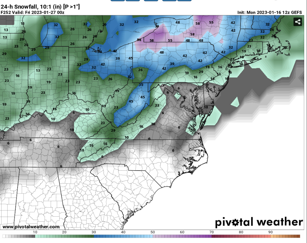
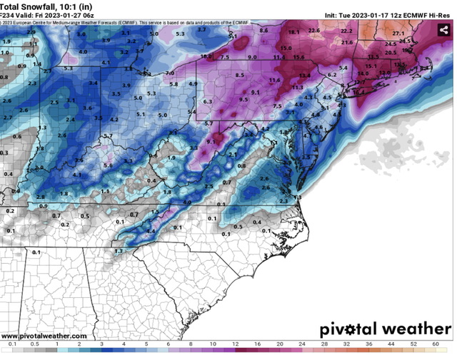
Maybe not the most believable evolution, but we’re in the game. CMC isn’t horrific either, but it’s more of a rain to minor snowfall event here with a monster storm that drops 2-3 feet in interior SNE. But that bullseye was in VA/NC on the 0z run, so there’s still a lot to be worked out.
-
Also, today’s low so far is 33. If PIT doesn’t get to 32 by midnight tonight, and it’ll be close, it will be the first time since observations moved to the airport that we’ve started a year with 6 days without a freeze.
-
The Euro’s depiction is even more frustrating than that. It’s a storm that rolls through the Deep South while we somehow still get into the 40s even with that storm track well south of us. This is getting comical.