TimB
-
Posts
17,206 -
Joined
Content Type
Profiles
Blogs
Forums
American Weather
Media Demo
Store
Gallery
Everything posted by TimB
-
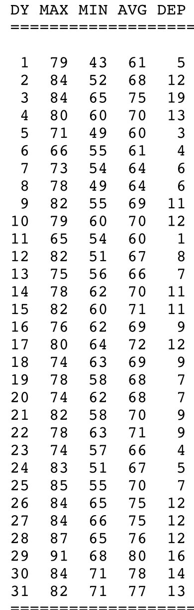
What if I told you this was the first half of a February at PIT that ended up at +7.7?
-
So +8 on the late September low would be 61. Not exactly sweltering or far-fetched.
-
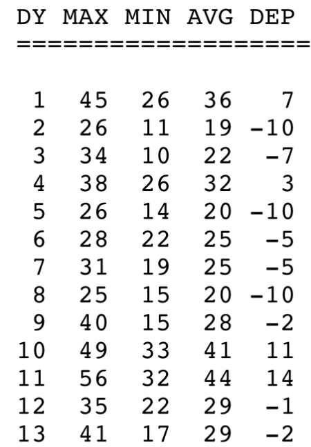
It’s not impossible. May 2018 was +8.9 at PIT relative to the old normals and looked like this: I would say if PIT can do it in May, MDT can do it in September. (Note that all 31 days were above normal.)
-
Going +8 on normals that increased by over a degree with the recent update would be a real feat.
-
And that’s saying something. On another note: Even not being an O’s fan, I’m confident that I know exactly what it’s like to be one.

-
It’s the only thing about Florida that can be safely discussed in this forum right now.
-
I would take a string of dry days with highs in the 60s/70s here over any digital snow at some other location, even if it’s 10 feet in Florida.
-
0z GFS Kuch snow map (look how close it is to the states):
-
That was once in a lifetime stuff. Can’t believe I forgot about it until now.
-
I’d feel a little guilty if something like that map I just posted actually plays out. Memorial Day weekend...front end of the 4th of July weekend...Labor Day weekend...
-
I’d take anything within 15 degrees of that.
-
But then again, there’s some incredible stuff on the 18z GFS. Most notably this: Note that this is NOT rain induced. DPs in the low to mid 40s, and some chilly nights on either side (MDT hits 48 the following morning).
-
It’s probably too early to write off September, even if the first week proves to be above normal. It’s just a sore spot for me, it was once one of the better weather months of the year but now it’s just an extension of summer many years.
-
I want to say the new September normals are the ones that increased the most when they updated them earlier this year, but don’t quote me on that. Finishing “only” a degree or two above the new normals would be a hollow victory to me.
-
Unfortunately it seems we’re quite a ways from being into more than a token day in the 70s due to clouds/precip here and there. If I had to put money on it, the next day PIT sees with a high in the 70s and zero precip is more than 2 weeks away, and you know what that means for MDT.
-
90 doesn’t appear to be on the table for me today, barring an increase of 4 degrees from here on out. Tomorrow appears to be our best shot.
-
It makes it into the US!
-
Good lord, not in here, man.
-
And can’t forget the Palouse.
-
That was a rare situation. Might have actually been trying to get through the first half of May 2020 without running the heat again.
-
If not, maybe someone else will beat the crap out of someone at a football game and we can talk about that again.
-
4 pages = 120 posts in a week. 17 posts a day. Almost a guarantee.
-
We’ve let it get as low as 54 before initially turning on the heat, but once it’s on it’s on.
-
I wish you luck on making it through the end of November without turning your heat on.
-
They could finish the season on a 39 game win streak to get to 77-85.