

Snowcane21
-
Posts
91 -
Joined
-
Last visited
Content Type
Profiles
Blogs
Forums
American Weather
Media Demo
Store
Gallery
Everything posted by Snowcane21
-
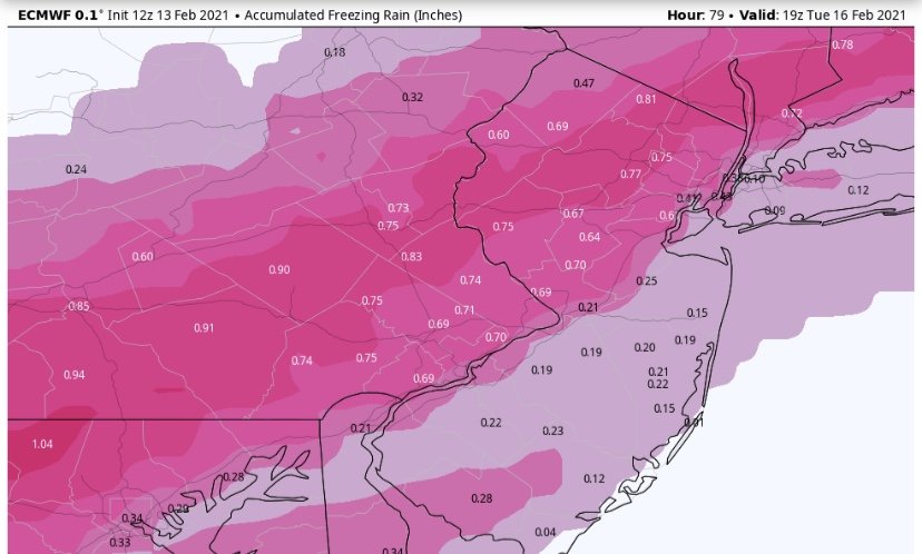
The Euro and it’s ensembles have been advertising a big ticket icing event for days now. It’s hard to bet against.
-
12z Euro is a serious Ice storm I95 NW.....
-
This will Not verify....
-
Agree... the 12z Rgem and the 12z icon depict surface temps of 32-33 with around .75” qpf. We are teetering on the edge here. This needs to be watched closely.
-
Agree with you there is still a very large, impactful Ice threat in the N and W Zones. Most guidance depicts temps 33-35 over the region. We’re still 3 days out. Not sure why this is being written off by many as Rain. I certainly wouldn’t be letting my guard down
-
NAM in the last frame is showing the cold air pressing into the area for Tuesday’s system. 2m temps crash north and west from 9z to 12z as the low takes shape and turns the surface winds northerly. Temps are 32-33 area wide prior to that occurring. No solution is set obviously but the threat of significant Icing for someone here is definitely still on the table.
-
1.9” in northeast philly. Steady light snow ... should end with about 3”... nothing quite like a fresh fallen snow overnight. If you believe the Euro. Most of the area will be getting 1-2” of Freezing rain between Saturday and Tuesday.
-
Are you East or west of the boulevard. The gradient is pretty steep in the northeast. Straddling county line I’m at 4”. We never rained. Was mostly all snow from the start
-
It’s possible. You gain decent elevation as you go north in the city and we often have much more snow than center city and the airport.
-
Same. About 4” far Northeast Philly. 5 miles to the nw. 10 inches around warminster.
-
One month compared to 15 years of superiority. Still riding with the Euro
-
Sooo the Euro was the ONLY model that showed this potential 5 days ago. It lost it for ONE cycle and somehow it’s fallen. While today is the First time the GFS even showed the potential. I’m riding the Euro for life.
-
So does it keep trending NW! lol
-
The 6z Euro just out is back to showing the storm in play. We now have the 6z suite making large NW adjustments
-
This reminds me of the Boxing Day storm. Euro showed it first. Then lost it. Then the gfs showed it and the Euro came back. We’ll see if this is just noise or are the models finally starting to figure the pattern out
-
As did the icon and NAM make major shifts NW. just noise or figuring out the pattern.....
-
This is the Shift on the Canadian in just 12 hours. Undeniable where we’re headed.....
-
Based on today’s trends we’ve moved from needle to basically a lay up lol. The cmc jumped about 300 miles west and the gfs made huge leaps towards the euro. All signals point to a major storm riding up the coast starting Saturday. Actually it has the risk of moving too far west on us.
-
Oh look. Another sleet show in philly lol. One of these times it will be all snow.
-
Hey now, the Philly proper and south and east crowd would like a decent, ALL snow event!
-
January 31-February 2, 2021 Major Winter Storm Observations
Snowcane21 replied to Ralph Wiggum's topic in Philadelphia Region
Yes, the sleet is chewing into those totals and needs to be accounted for. -
They flipped places with the Euro lol. Can’t even make it up sometimes.
-
I noticed that wording as well. Interestingly the Philadelphia county warning says TOTAL accumulations 8-12”. Not sure how that’s going to work out. Considering the city has already had 4”
-
Was just going to post this lol. Indeed the latest run is “leaning” more towards pushing the banding back into pa. We shall see how it trends


