Snowcane21
-
Posts
91 -
Joined
-
Last visited
Content Type
Profiles
Blogs
Forums
American Weather
Media Demo
Store
Gallery
Everything posted by Snowcane21
-
Puts them at 23.2” for the season officially at the airport. Which is now an ABOVE average snow season. Northeast airport is officially over 30” for the year...
-
HRR had 5.4 lol.
-
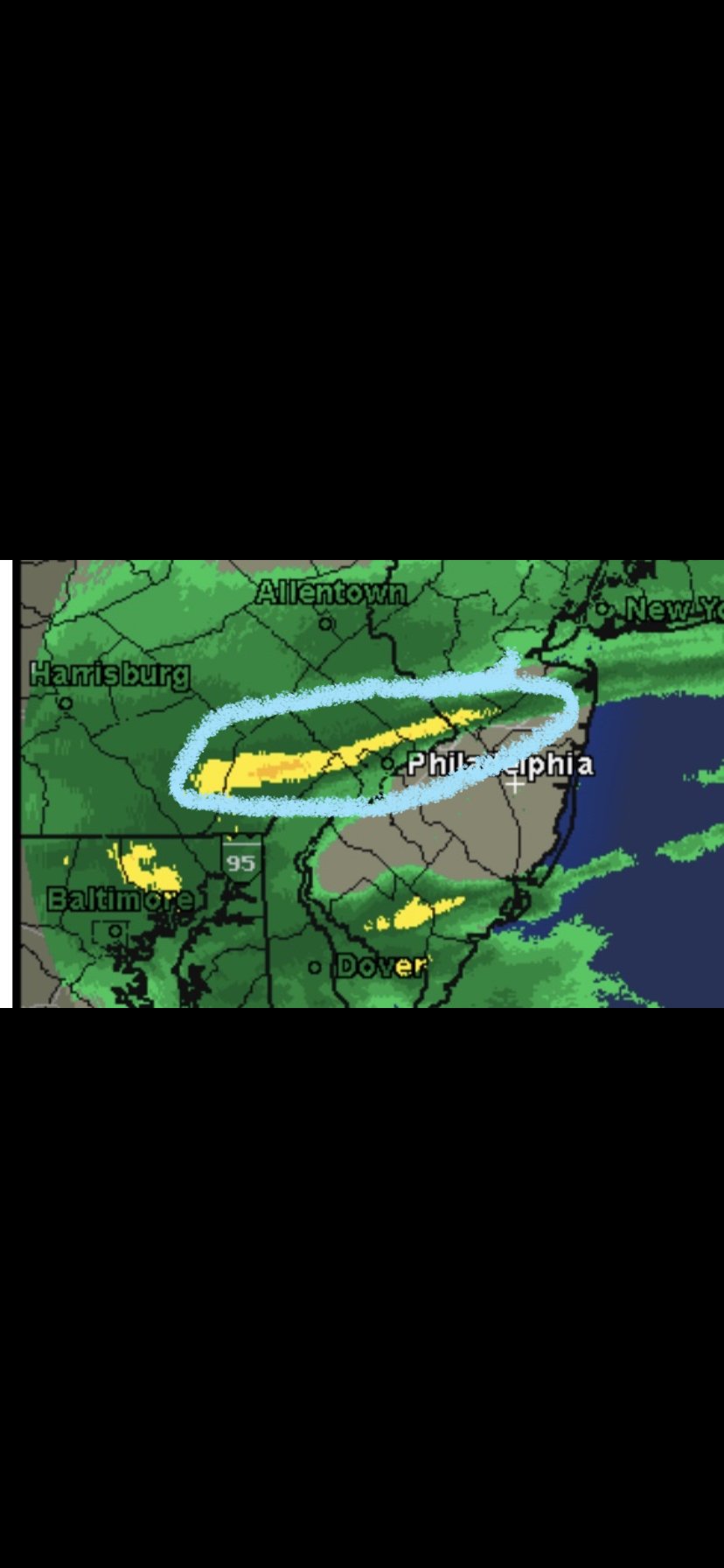
Skies darkening rapidly in the city now. Very heavy returns just to the southwest. A wall of snow is encroaching on the city. Travel should quickly become challenging ...
-
Sterling just extended the WWA to Baltimore and DC proper. Will Mt holly follow and extend down to 95....
-
Incredible conditions right now in northeast Philly. Baseball size snowflakes crashing down with some sleet. Never saw snow flakes this size before. Quite the site. 90/10 Snow currently
-
Yep. Getting crushed. Totals will range between 12-16” in that corridor
-
7.1” now here. Snowing at an incredible rate again. Visibly a few hundred feet. Parts of the area going for 10-14” no doubt. Reports out of eastern montco. approaching a foot already and heavy snow is continuing
-
6.2” here. Amazingly still all snow. But lightest rates we’ve had all day. Moderate size flakes. 23f.
-
Yep. That band was incredible around 6 am. Heaviest rates of the season here. Parts of extreme lower bucks and eastern montco going to end up with 8-12”. If sleet holds off even more
-
Half a foot now in far northeast Philly. 19116 Moderate snow now. Under that last heavy band did have some sleet but has gone back to all snow small flakes.
-
4” here as well I. 19116. Far northeast Philly.
-
3” since 430... ... heavy snow continues. For now......
-
You are Correct
-
Sleet line still south of Dc. We have a chance to really thump this morning
-
1.8”. In far northeast Philly. 19116. Heavy snow continues to fall ... visibility down to a few hundred feet.
-
Incredible snowfall rates occurring in this band. Just south of warminster to the very edge of northeast philly. 1-2” has fallen in the past 45 minutes

-
We’re on the edge of that band. Lower bucks and eastern Montgomery-Lower are getting absolutely crushed. 2” rates. Incredible
-
Heavy Snow in 19116. .5” in 15 minutes. Winds gusted to 30. Very intense start. Unexpected.
-
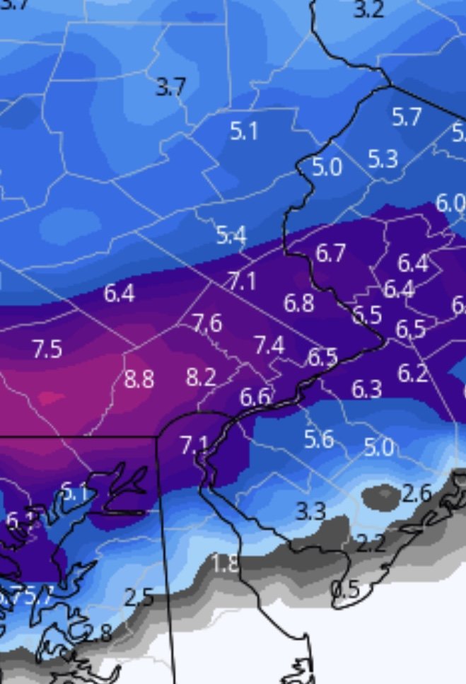
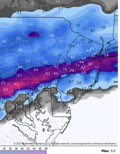
No, Kphl has much more sleet on the 0z run. Qpf essentially unchanged. Qpf field shrunk up north yes. But the snow reduction for the city is due to earlier sleet
-
0z/18z

-
Compared to 18z it’s much less snow for philly due to sleet much earlier
-
NAM is racing the sleet line .. it’s the only model depicting it moving like this. But it’s now within range to be taken seriously ... living in the edge. Philly gets into some heavy precip could really boom or bust here.
-
Getting snow in before dawn is key to offsetting sun angle. If we can lay done some cover early it makes a world of difference
-
Agreed. This is The snow map off the NAM. NO sleet
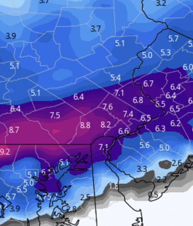
-
Yes it does. It says it right in the map. *includes Sleet*. Come on guys.