SnowenOutThere
-
Posts
4,007 -
Joined
-
Last visited
Content Type
Profiles
Blogs
Forums
American Weather
Media Demo
Store
Gallery
Everything posted by SnowenOutThere
-
Man there are some great posts from those threads, for example here is @Ji take on the matter

-
Went back to look at the 2016 blizzard threads and found this one. Great call @DCAlexandria
-

Late January and February Medium/Long Range Discussion
SnowenOutThere replied to WinterWxLuvr's topic in Mid Atlantic
*Terms apply Terms being you are east of @Ji- 4,130 replies
-
- 3
-

-

-
- prime climo
- cold canada
- (and 1 more)
-
Late January and February Medium/Long Range Discussion
SnowenOutThere replied to WinterWxLuvr's topic in Mid Atlantic
Wow, what a run- 4,130 replies
-
- 5
-
-

-
- prime climo
- cold canada
- (and 1 more)
-
Late January and February Medium/Long Range Discussion
SnowenOutThere replied to WinterWxLuvr's topic in Mid Atlantic
Holy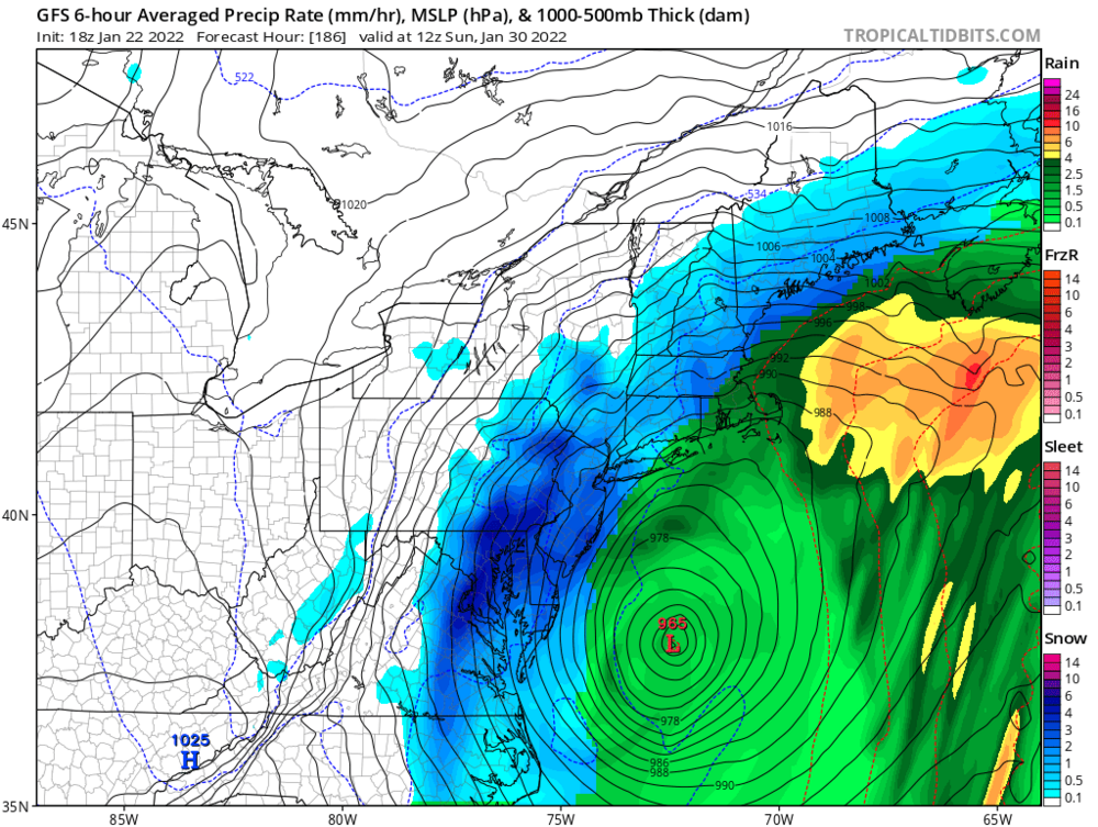
- 4,130 replies
-
- 6
-
-
- prime climo
- cold canada
- (and 1 more)
-
Late January and February Medium/Long Range Discussion
SnowenOutThere replied to WinterWxLuvr's topic in Mid Atlantic
looks pretty fun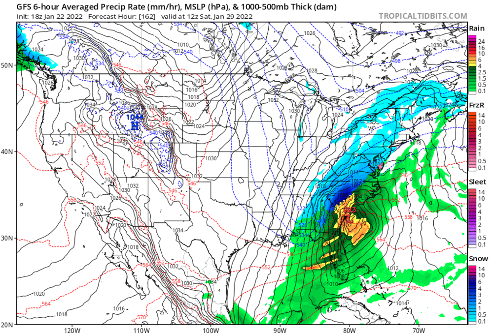
- 4,130 replies
-
- 1
-
-
- prime climo
- cold canada
- (and 1 more)
-
Late January and February Medium/Long Range Discussion
SnowenOutThere replied to WinterWxLuvr's topic in Mid Atlantic
Did not realize how many people here dislike my posts, sorry about that will try to do better in the future.- 4,130 replies
-
- 7
-
-
-
-
- prime climo
- cold canada
- (and 1 more)
-
Well in the past couple weeks I’ve been back in school, meaning this site is now my main source of entertainment.
-
No that post was helpful, I just find it upsetting if it’s a post pointing out I’m not that intelligent when it come to weather with no advice on how to get smarter. I understand that as someone who is pretty young that there are people who have spent more than 50 years caring about weather so it makes sense I have no idea what I am doing but would like it if instead of pointing out the obvious there is an attempt to actually help people like me.
-
Late January and February Medium/Long Range Discussion
SnowenOutThere replied to WinterWxLuvr's topic in Mid Atlantic
Ask psu what winter was better. Ask Winchester people How about we ask people like Cape which winter was better so far, or people in DC. -
Ok, but like text resources like a book or some NOAA pages so I don’t need to interpret posts to learn stuff about phasing and other atmospheric dynamics.
-
Alright how can I be a better poster, any resources I can read or something so I can learn and try to understand how the atmospheric maps translate to the surface? That would be a lot more helpful than just saying I’m not a great poster.
-
Hey, I’m not trying to lie. I just am not that experienced and trying to learn and make observations. No need to be a jerk.
-
Late January and February Medium/Long Range Discussion
SnowenOutThere replied to WinterWxLuvr's topic in Mid Atlantic
Euro has southwest energy at 84 digging further south to the four corners -
Late January and February Medium/Long Range Discussion
SnowenOutThere replied to WinterWxLuvr's topic in Mid Atlantic
Do not look at the CMC -
Late January and February Medium/Long Range Discussion
SnowenOutThere replied to WinterWxLuvr's topic in Mid Atlantic
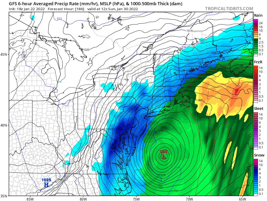
What a bonkers set of 12z model runs. The Euro has over a foot for Atlanta and then cold rain up through Maine, GFS has a biblical snowstorm for the southeast and the GGEM also has a storm. The important thing is they all show something. -
Late January and February Medium/Long Range Discussion
SnowenOutThere replied to WinterWxLuvr's topic in Mid Atlantic
- 4,130 replies
-
- 1
-

-
- prime climo
- cold canada
- (and 1 more)
-
Late January and February Medium/Long Range Discussion
SnowenOutThere replied to WinterWxLuvr's topic in Mid Atlantic

- 4,130 replies
-
- 9
-
-
-
-
- prime climo
- cold canada
- (and 1 more)
-
Late January and February Medium/Long Range Discussion
SnowenOutThere replied to WinterWxLuvr's topic in Mid Atlantic
- 4,130 replies
-
- 1
-
-
- prime climo
- cold canada
- (and 1 more)
-
Late January and February Medium/Long Range Discussion
SnowenOutThere replied to WinterWxLuvr's topic in Mid Atlantic
I guess the 12z GFS runs are the new happy hour runs that give us snow. -
Northern stream kills it soon after
-
Euro has a gulf low at 114 hours out
-
I'm not wrong its just being "fringed" is getting around 20 inches of snow. Not upset with the run just pointing out we sort of get fringed, sort of as a joke.
-
We get #fringed where is PSU
-
Thursday 1/20/22 Stat Padder Discussion and Observations
SnowenOutThere replied to stormtracker's topic in Mid Atlantic
Winchester gets screwed over, metros still chilling