

WXNewton
-
Posts
302 -
Joined
-
Last visited
Content Type
Profiles
Blogs
Forums
American Weather
Media Demo
Store
Gallery
Posts posted by WXNewton
-
-
13 minutes ago, wake4est said:
Eww. Para vs. OG.


Also the hole on the para in the NC foothills is quite a bit of sleet.
-
12z Canadian more in line with Para GFS
-
4 minutes ago, WinstonSalemArlington said:
But how does a low go north with those dynamics?
Yeah something doesn't seem right about that. I believe if it does run north toward TN it should be like hitting a wall and go under wedge and redevelop on the coast. I would say that this is going to need a few days to be resolved.

-
 1
1
-
-
12z GFS can't get the high out front fast enough and it's weaker, looks a lot like last nights Euro.
-
3 minutes ago, olafminesaw said:
ICON straight up doesn't make sense. A strong low low passing just to our north, and temps never rise above 25 for many?
The high stays in a pretty decent position for most of the storm and is right over the heart of NE snow pack, I assume the feed of cold air stays locked in and transporting NE winds over temps in the single digits and teens.

-
1 minute ago, Blue_Ridge_Escarpment said:
Yeah that would be crippling.
The southern fringes of the wedge warmed up some from 00z but in the heart of the CAD region temps stayed pretty close to 00z. Low did track toward the APPs this run and Miller-B around the southern edge of the wedge to the coast.
-
12Z ICON looks like it could be setting up for something nice, HP moving to the east in conjunction with low pressure over the gulf. If the high can build in first and stay out in front it should be a big run.


-
12Z RGEM coming in colder from 6z and colder than 12z NAM

-
1
-
-
2 minutes ago, BullCityWx said:
It got really close. A degree or two and most of NC is in it.
Thanks, lets see what the NAM says.
-
16 minutes ago, BullCityWx said:
One more trend like this and the northern tier of triad and triangle counties are going to be in the snow.
Did freezing rain make it into the Catawba Valley area?
-
12z ICON also looks like major ICESTORM for Tuesday as well.
-
2 minutes ago, frazdaddy said:
I like weather. One of the reasons I do, is many times over my long life in North Carolina it has been extreme. An ice storm in 1967 that paralyzed NC for the better part of a month to the hurricanes. The snow storms, that time a half inch of grauple brought traffic in Raleigh to a stand still leaving hundreds of motorist stranded overnight. Those times hold some very interesting memories , good and bad but I got something out of every event.
At the end of the day it doesn't matter what we want or don't want it's going to be what it will be. The interest in interesting weather is why most are here I think. I know it is for me.
Not many memories from 33 and rain but 25 and freezing rain will create an everlasting memory. I think for me it's something that takes the ordinary daily living away and for a day or two you can experience something that is extreme.
-
1
-
-
Just now, BullCityWx said:
It could definitely go that route. If you were going to ask me for a perfect scenario for a multi-day freezing drizzle event, this is pretty much it. Rare around these parts but so is the cold air
That would be worse case scenario for car accidents. I remember light icing events where models and even the radar had trouble detecting the moisture and many roads and bridges becoming impassable. Again this seems like something we haven't seen in a while but can lead to many issues with travel.
-
1
-
 1
1
-
-
6 minutes ago, BullCityWx said:
Also tries hard to have mostly sleet N&W of 85 in the triad and triangle.
Maybe today the trend will be for a 2nd batch of precip building in during the early morning hours on Saturday. With the frigid airmass to our north slowly sinking in this would possibly lead to a lot of light freezing drizzle/sleet that might be more extensive than the models are detecting.
-
4 minutes ago, BullCityWx said:
My guess is there's no way there's that much zr(geographically speaking). Probably a ton of sleet somewhere.
Lets hope! This could be the big dog, seems like all 3 global models now have the high pressure in a similar position and with moisture overrunning the CAD. In the past it seems like the euro latches on to these bigger storms first and now we are seeing some agreement on timing, temps and moisture.
-
20 minutes ago, JoshM said:
6z GFS has entered the chat

.thumb.png.7883cbdc0a926fa9bba16871eec14a22.png)
-
Freezing Rain

-
Looks like 00Z RGEM has much better CAD setting up at hr 51. 00z RGEM and 00z NAM still pretty far apart.


-
2 minutes ago, BornAgain13 said:
0z NAM going back to its other solutions. Ticking back north unfortunately
Yep just noticed that too, it's difficult to watch the models literally bounce around 10-14 degrees different in one or two runs. This run had a low pressure off the coast that wasn't on 18z.

-
Just now, Orangeburgwx said:
What's the next run, Happy Hour GFS?
Sent from my LGL322DL using Tapatalk
18z RGEM will be out soon
-
Also one thing to note this is a wedge building in as moisture is arriving. Lately we have been wedged in waiting for the moisture and by the time it gets here the high is retreating.
-
1
-
-
Just now, BornAgain13 said:
Geez , this thing is trending colder quick!
Yep big chances today and they all started with RGEM. Lets see what it does in a little bit which might lead the way again for another shift south tonight.
-
The trend is alive and well...


-
7 minutes ago, BornAgain13 said:
Yeah the CMC/RGEM really looked intriguing...
I think the key to the end of the week storm is all about timing, which in most ways that's the big puzzle piece to getting any winter storm in the south. Both the Euro and Canadian have the CAD building in stronger throughout the day on Friday and into Saturday. If the system would happen to slow down some and the cold air filter in a little quicker we might have a better chance.
-
 1
1
-

.png.2a61142e447c441adc88a4e4ff3dbcf4.png)

Mid to Long Term Discussion 2021
in Southeastern States
Posted
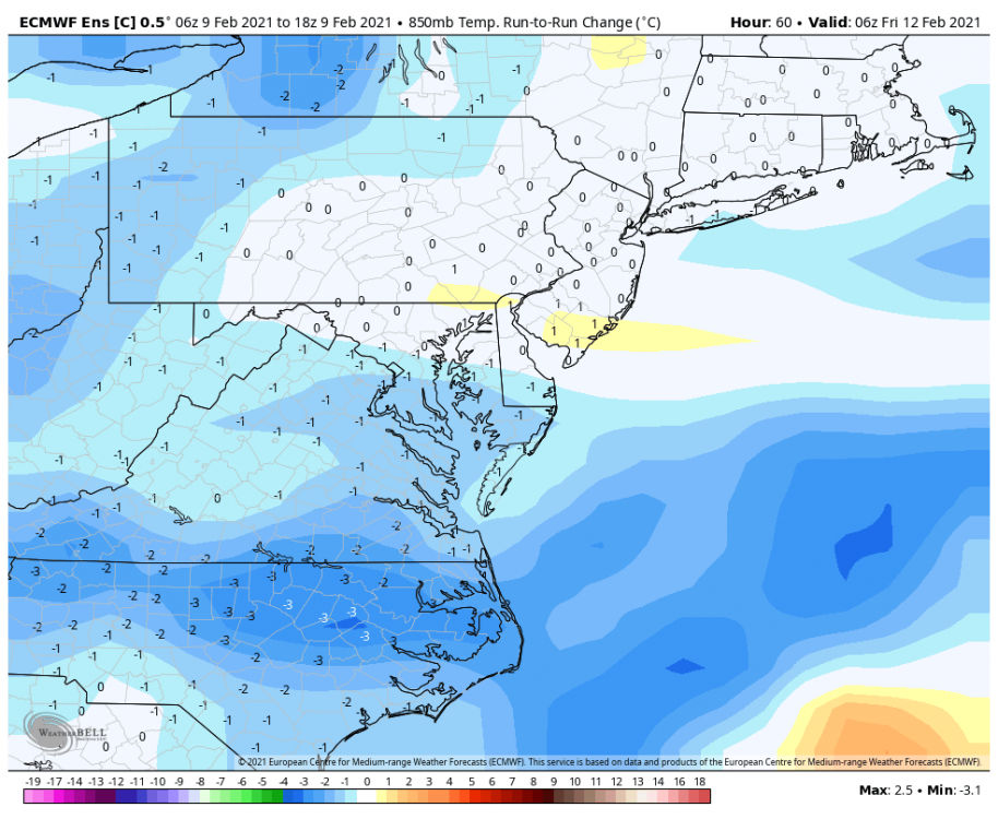
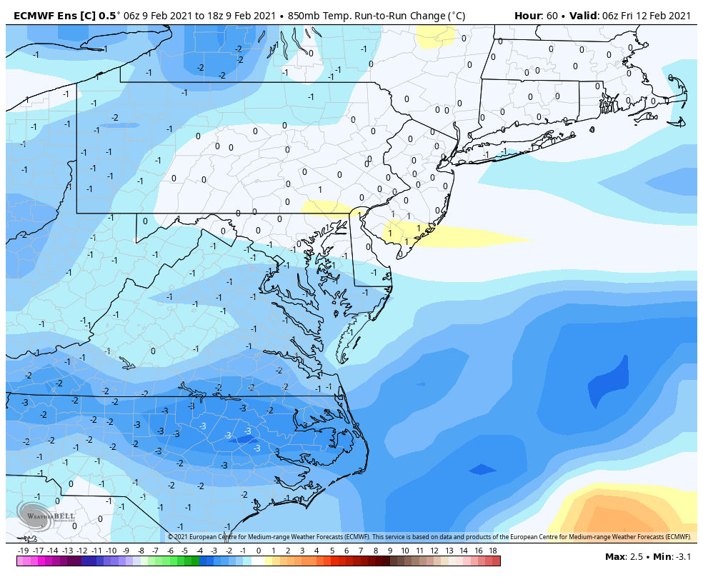
hr 120 Raleigh is about 3 degrees colder CLT is around 1 or so than 00z