

WXNewton
-
Posts
302 -
Joined
-
Last visited
Content Type
Profiles
Blogs
Forums
American Weather
Media Demo
Store
Gallery
Posts posted by WXNewton
-
-
Nam 3km Trended further south with frozen precip and 850s trended much further south too.


-
Pretty big shift south with precip.

-
Small shift south with 540 line at hr 42. Surface temps running several degrees warmer along 40.

-
 1
1
-
-
14 minutes ago, avianman said:
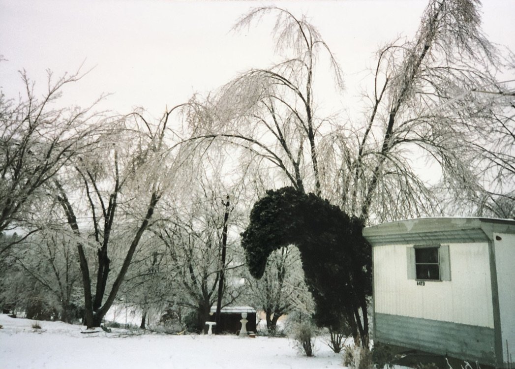
This was northern Catawba County Feb '96

Gave me goosebumps looking at this picture. I remember the mattresses in our house froze. That was a scary storm, I didn't sleep for 2 nights because of all the pine trees popping around the house. My dad worked for the DOT and he didn't come home for days.
-
1
-
-
Somebody needs to put the brakes on this low pressure, I mean NW trend but dang couple hundred miles if that keeps up.

-
1
-
-
2 minutes ago, Blue_Ridge_Escarpment said:
850 and 925 are below freezing. Not sure if I buy that.
They look good to me


-
2
-
-
Just now, wncsnow said:
NAM gonna be a big hit for WNC, especially SW mtns
Running a little colder too.

-
1
-
-
3 minutes ago, HKY_WX said:
Euro paints a pattern similar to late Jan/Feb of 96. Full scale arctic blast with overrunning on the SE side for the entire SE.... Really hard to get this to happen, so we need to reel this in to at least inside 7 days bf getting excited. This has more of mid 1990s look to it.
I just thought the same thing! Feb 2, 1996 was the worst ice storm I remember in Catawba County. Trees popped all night long was without power for 8-9 days and temps got down near zero a day or 2 after the storm and had several inches of snow on the very end. That was the storm that had me hooked on winter weather.
-
2
-
-
4 minutes ago, jrips27 said:
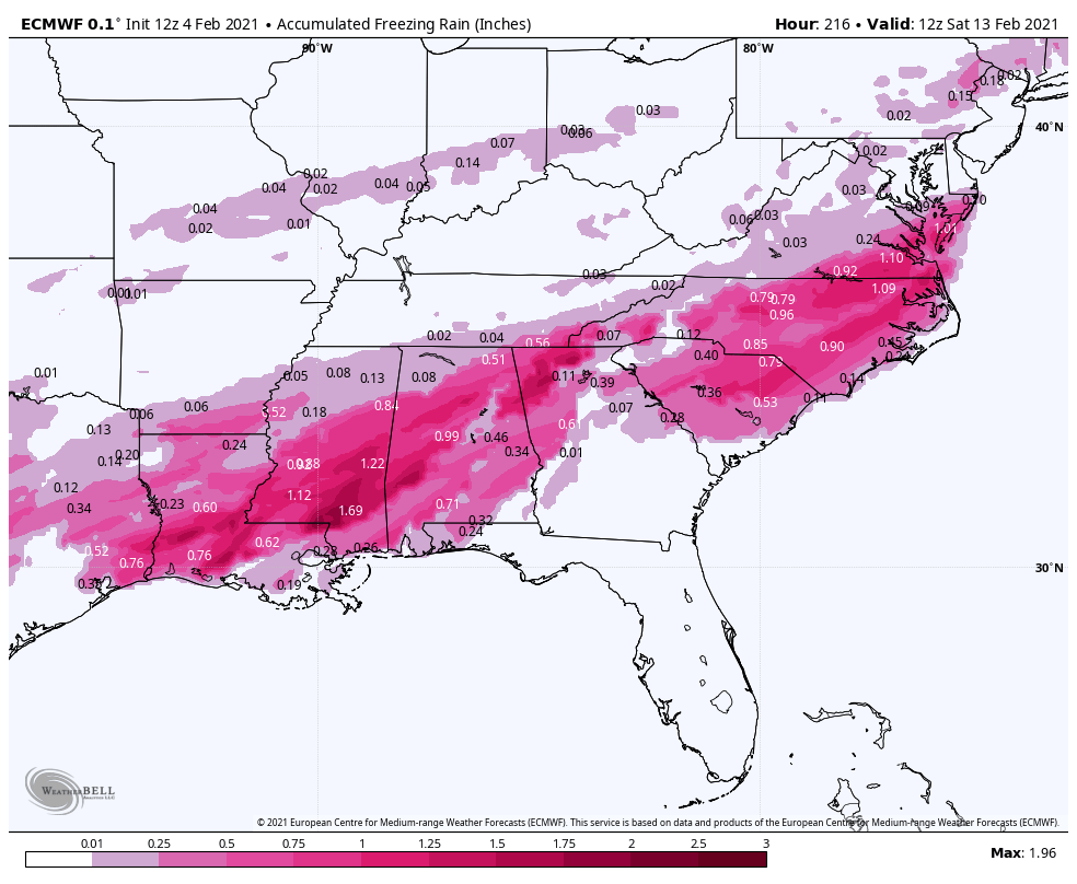
Wider ZR view of the whole region. Ouch

If we get that much ice and these temps come in afterwards it would be devastating.

-
1 minute ago, BullCityWx said:


GFS para showing significant icing as well.
-
1 minute ago, BullCityWx said:
Looks like we're gonna go from freezing rain to snow. we dont usually go in that order.
The cold is for real, but it bleeds in slow coming from that trajectory. It looks like the boundary stalls out to our south and several weak waves of low pressure ride up over it. Are there several impulses that get ejected this way or does this evolve into one major storm? To me this could just as easily be a setup for long duration icing event with overrunning precip and maybe it does trend from ice to snow as deeper colder infiltrates our area.
-
Euro coming in with a monster storm on Friday...So much cold air to the west and just slowly filters in over the Apps.
-
3 minutes ago, Orangeburgwx said:
Euro out to the 11th, slight more ridging out west

Sent from my LGL322DL using Tapatalk
Wow 1051 hp building in too. Get that to scoot on further south and no way that thing will cut on us.
-
Does the Euro have a map for sleet out-put or is that counted in with snowfall?
-
9 minutes ago, buckeyefan1 said:
")

Looks good to me, typical North of 85 storm and marginal temps. Hopefully we can get some decent rates, been skipped over in the Northwest Piedmont this year, at this point I'll be happy with anything frozen.
-
3
-
-
8 minutes ago, WXNewton said:
For Sunday's storm the Canadian is moving toward the other models. One more trend like this would definitely put some snow in WNC.

Looks like Upper low keeps digging stronger and further south each run too, I think it will keep correcting like this for a couple more runs.

-
For Sunday's storm the Canadian is moving toward the other models. One more trend like this would definitely put some snow in WNC.
-
1
-
-
11 minutes ago, Orangeburgwx said:
FV3 has the low way inland for next weekend, rockets out of here so no storm
Sent from my LGL322DL using Tapatalk
Looks like to me low is crawling across the gulf and potential major winter storm with high locked in over top.
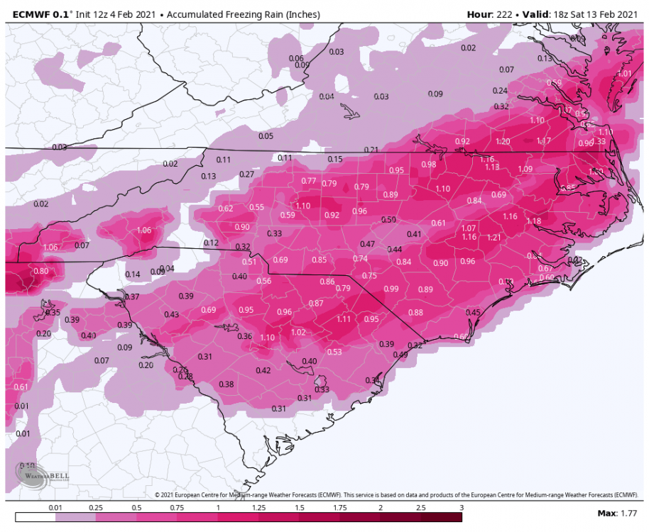
.thumb.png.c316e78e9ea33a226ef82419ca08ed9e.png)
.thumb.png.89a6007c0ac8918aab0cc8ff6b3d6a7b.png)
.thumb.png.dc8d5c9c016d5948b8f579a3fac10f80.png)

-
1
-
-
1 minute ago, Chuck said:
But of course! Was there any doubt?
I wouldn't get too worried this far out, I mean we are only 2 days a way from the weekend storm and models are still trying to figure it out. I really would be too concerned past day 3-4 at this point.
-
4
-
-
One thing to maybe watch for is if we can get some wedging or at least some colder air bleeding in from NE. The GFS para showing a weak high over eastern PA as the moisture is coming in. This is the first time I've noticed that feature there.

-
ICON also coming in with a similar track and getting the NW Piedmont in some snow.

-
GFS para 850s trend over the last 3 runs

-
RGEM not amped like the NAM, but it's trending NW and stronger each run, maybe we can find a happy medium on the models.

-
This setup kinda of reminds me of this storm back in 08. https://projects.ncsu.edu/atmos_collaboration/nwsfo/storage/cases/20080117/
-
1
-


.png.37cc8a7518057463c4662e8cda9869f1.png)
.png.fd330597f46b75df3633f9f0c2efeb8a.png)
.png.be303fbdc59d8e44d435c970a8f92288.png)


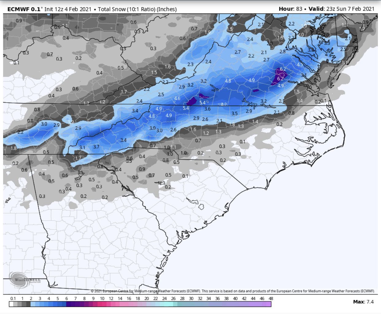
2/6/-2/7 Snow Threat
in Southeastern States
Posted
3km trended a little better for foothills than 18z.