

WXNewton
-
Posts
302 -
Joined
-
Last visited
Content Type
Profiles
Blogs
Forums
American Weather
Media Demo
Store
Gallery
Posts posted by WXNewton
-
-
24 minutes ago, calculus1 said:
Lowest temp overnight for me was 32.3. no visible signs of icing. Light drizzle continues.
Sent from my moto e5 supra using Tapatalk
Yep got to 32 even at one point, man the radar looks good, almost has the shape of a snowstorm to it.
-
 1
1
-
-
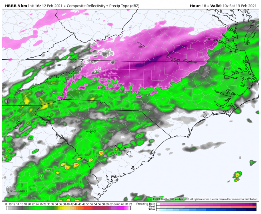
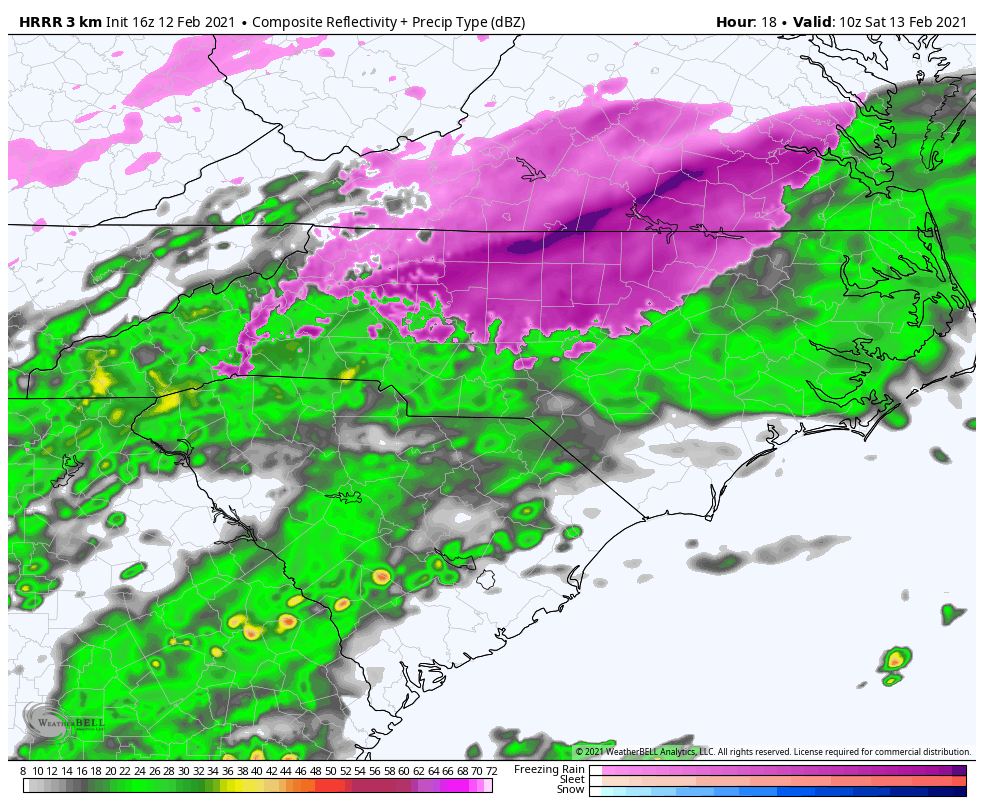
00z Canadian has a lot freezing rain this run for much of the state even gets HKY down to 30. Seems a little too cold though.
-
Already 32.9/31.6 here, I know that's lower than any model had us at this point. Also RGEM really moved freezing rain totals south.
-
1
-
-
3 minutes ago, PantherJustin said:
33 4.5 Miles N of Davidson not sure what we were supposed to be I’d say 35/36 if I had to guess
Yeah seeing a lot of temps around freezing already just North of Statesville, a degree or two in this setup could be a huge deal!
-
1 minute ago, wncsnow said:
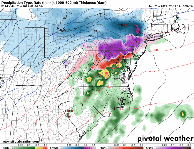
If that last storm late next week does take a true miller A track it may be the best threat of any of these systems the past week. The cold will be rotting by then but it's still plenty cold enough just to our north and west
Yeah definitely a threat to pay attention to, hopefully Monday's storm will help the trough axis swing more to the east.
-
2
-
-
1 minute ago, BullCityWx said:
That looks like it's going to get nasty! Catawba county getting closer each run. 34.4 here.
-
2 minutes ago, AirNelson39 said:
Typical 33 and moderate rain here in Hickory. Perfect WWA conditions....sigh
Yep 32.6 here in Newton, just not our year.
-
2
-
-
3 minutes ago, Buddy1987 said:
12k Nam already looking much more juicy at hr 33. Let’s see where this run goes. Coverage also looks like it was better portrayed on 12k vs 3k for the current event rolling through now, at least for my direct area.
Nam has freezing rain now all the way into Catawba County.
-
8 minutes ago, griteater said:
I wanted to post that GIFs are kind of my specialty, but for some reason all of my files are too large to upload.
-
18z para trended with more freezing rain for Tuesday storm, actually made a big leap south with ice.
-
 1
1
-
-
6 minutes ago, BornAgain13 said:
The NAM will be interesting when it gets in range for Tuesday
Come on NAM!! I wouldn't at all be shocked for it to suck us all back in.
-
2
-
-
Thunder popping in Catawba County, just shook the whole house.
-
2
-
-
Interesting that 12z ICON shows main low tracking across the gulf again and not cutting on us. The wedge didn't build in quick enough, but this shows models still have some figuring out to do.
-
23 minutes ago, tarheelwx said:
Why are we not getting the true CAD wedge? For instance, the maps above show Durham more at risk than Mt Airy. Seems if a true CAD, Hickory to Mt Airy should be the heart of the freezing rain.
TW
That's what I was saying last night, the RGEM shows more of a traditional CAD look back here in NW Piedmont and foothills.
-
You would think in this setup with the wedge building in as the precip moves in from the south that most places would stay all freezing rain once they get locked in. I am not sure I buy any warming up besides the latent heat released.
-
RGEM does the same thing as the NAM and builds the wedge back in later in the day.
-
4 minutes ago, Buddy1987 said:
RGEM looks Uber cold as well for a good portion of the triangle between 60-66. Nicely well defined wedge.
At 72 the icing output is much lighter up this way but more serious down toward Greensboro and areas directly surrounding.RGEM looked more like your typical wedge with colder temps back in the NW Piedmont compared to the NAM that was more east based wedge.
-
5 minutes ago, BullCityWx said:
Was that on FB live?
During his 5 o'clock news and yes he had a couple videos on FB too.
-
Also saw Brad P. in house model tonight and it had almost all of NC in Freezing rain and dropped temps in HKY to 31. It was definitely interesting and seems like other guidance is not too far off from what he was showing. He also seemed a little more excited about a legit ice threat.
-
Just makes me wonder about Mon/Tuesday storm after watching the trends today. Do we see the same thing happen with that storm as we get closer with the wedge showing up a little stronger each run and pushing deeper to the south?
-
1 minute ago, tarheelwx said:
Somebody's got to say it. 00z NAM is a bit weaker with the low and the wedging is a bit stronger on Friday night.
TW
Yep definitely trended further south with temps and precip. The wedge dug down more in the eastern part of NC this run.
-
18z Nam colder and more freezing rain for Saturday.
-
1
-
-
1 minute ago, NorthHillsWx said:
If I had to make a forecast for this event that’s exactly what I would do for this: trust climo. Seems to fit well averaging all model solutions as well
Totally agree, I remember a storm in Jan of 2016 where models were trying to run the low right through the wedge particularly the GFS. A day or so just before the storm it started going with the other guidance and running it around the wedge and redeveloping on the coast. I think the Nam may do well with this storm once we get in that time frame.
-
Euro definitely made a step in the right direction, not far off from a major ice storm. I would put it more in the ICON, Para GFS, Canadian UKMET category but also the warmest of those, still closer to a major storm than GFS.
Ice/Snow threat Friday-Sunday
in Southeastern States
Posted
Looks like a scene out of a movie.