

WXNewton
-
Posts
302 -
Joined
-
Last visited
Content Type
Profiles
Blogs
Forums
American Weather
Media Demo
Store
Gallery
Posts posted by WXNewton
-
-
6 minutes ago, btownheel said:
Pushing that wedge in better.
Really starting to look more and more like RGEM
-
Just now, olafminesaw said:
I think this might be the in house model that Brad P. uses.
-
Just now, Blue_Ridge_Escarpment said:
Just look at that wedge.....mercy.
With a look like that you would think that would dig a little deeper. I still think models won't lock in until tonight into tomorrow morning. I would go with a blend of NAM/RGEM at the moment.
-
4 minutes ago, Tullioz said:
It may not have been a record, but the ice storm that occurred February 10-11,1994 had some pretty impressive accumulations of ice in NC. It was by far the worst ice storm I ever experienced. In my weather journal I recorded two inches of snow/sleet and 1 1/4" of ice accrual. I was without power for nine days. There were higher amounts of ice reported across the state (Up to 2") and many went without power longer than I did.
Here's a link to a short summary of that event: https://climate.ncsu.edu/climate/winter/event_details?e=132
I remember this storm! I believe that's when Neil Bonnett was killed at Daytona. We were hit hard in Catawba County as well.
-
 1
1
-
-
18z GFS trying to come in with a front end thump of snow in Foothills and Mountains.
-
1
-
-
3 minutes ago, NorthHillsWx said:
Lol. I think the icon actually did fairly well with surface temps on the last event. Seems slightly colder and “wedgier” this go round. Definitely keeps parts of the triangle as ice through most of the event. CAD regions would have a major ice event
The ICON nailed the snow that we got in Catawba County on Feb 6th and stayed consistent for 7-8 runs in a row. Its been consistently showing this now for 4-5 runs.
-
1
-
-
1 minute ago, wncsnow said:
One reason this Euro run is better is it keeps the low track further south
Looks like it wants to track the low right around the bottom of the wedge, if that's the case I have a very hard time buying the wedge lifting out as quickly as depicted.
-
Hr. 72 Euro much further south with wedge than previous runs, freezing rain down into Lincoln County this run.
-
Hr 66 dropped HKY 3 degrees from last night. Again I think globals will trend toward mesoscale as we get closer.
-
Hr 60 Euro keeping precip confined more along the gulf coast than the previous 3 runs.
-
12z UKMET not there yet but has trended pretty far south with temps the past 3 runs, its more in the GFS/EURO camp.
-
-
3 minutes ago, weatherlover said:
For who?
All of your CAD regions. 2/3 of NC, worst around I85 North and West.
-
12z RGEM also major ice-storm looks very similar to ICON
-
12z ICON once again with major ice-storm.
-
1
-
-
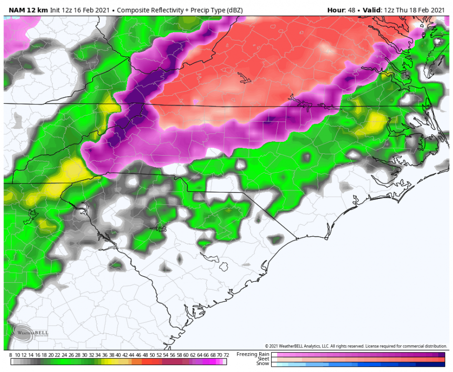
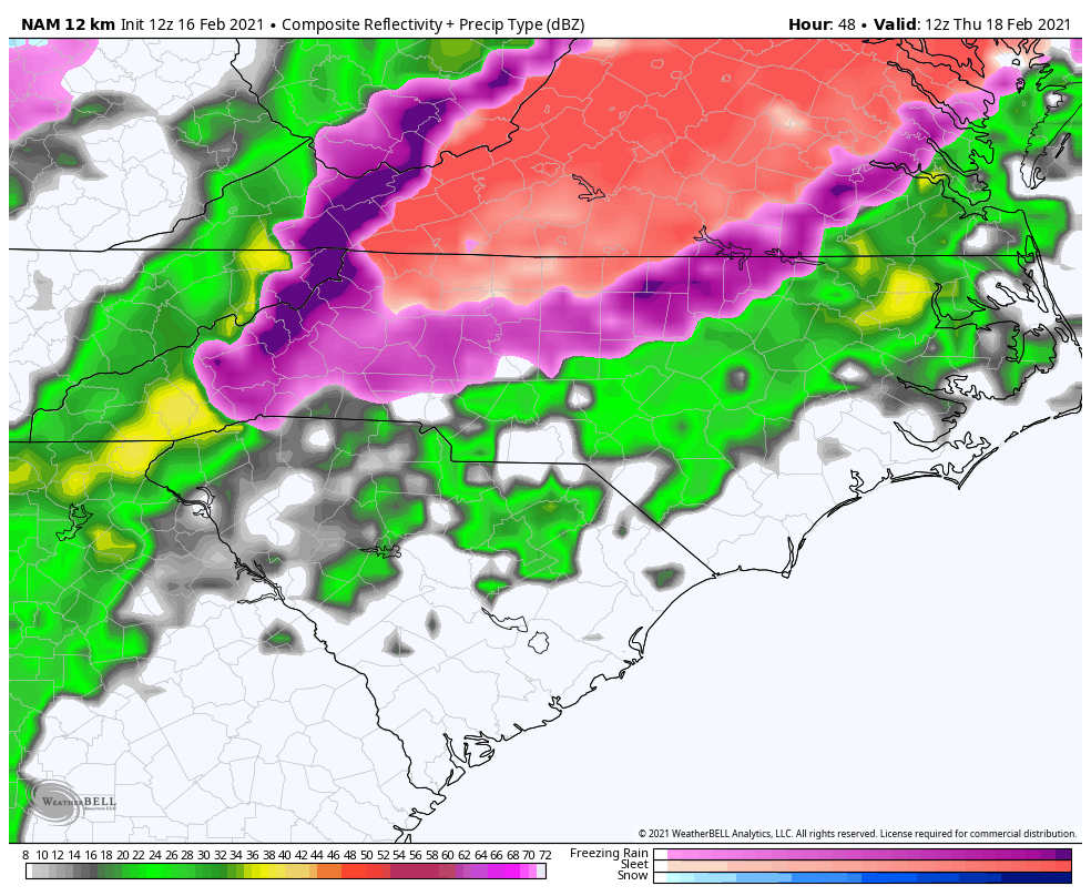
12z NAM looks pretty close to 6z. According to the NAM the High pressure is not really retreating like we've seen in storms before. It basically provides a NE flow for most of the storm, I mean it takes 12-14 hrs to move from NW PA to NH. Actually the high strengthens from a 1033-1037 over this time period. To me a retreating high would be exiting much faster than whats being shown.
-
1
-
-
Just now, Blue_Ridge_Escarpment said:
Seems like the NAM has been underdone on qpf since it underwent its upgrade.
Yep noticed this on Saturday's storm, it dried up a lot in the 36-48 hour time-frame and then trended wetter and wetter to play catch-up under 36 hours.
-
2
-
-
12z HRRR. showing some nasty zr totals along the escarpment tomorrow morning.
-
21 minutes ago, PantherJustin said:
I agree, but what are we missing? Local guys all saying Rain and some talking severe ....
We are just now getting into the short range guidance time-frame. I think if runs continue to show this threat and increase the chances today and tomorrow they will change their tune some.
-
1 minute ago, weatherlover said:
Is this a reliable model?
In my opinion it runs colder at the surface than any other model, I would say the NAM did a better job of Saturday's system inside 36 hours.
-
So now we have the ICON, Canadian, RGEM all showing a prolonged ice storm with the wedge holding in the CAD region for the entire storm. The NAM is still a major storm for many but moisture looks less, GFS is a major ice storm but not as far south as other guidance as well as the EURO. In my opinion models will continue to get a better handle on the wedge as today and tomorrow storm leaves the region. There is a ton of cold air to work with and timing looks to be setting up nicely as the high pressure system slides right into a favorable spot and strengths before the moisture flows into our region. Global models have been trending colder for this storm, but I think the mesoscale models will lead the way starting today and tomorrow. I think the biggest takeaway from this setup would be that all models are in agreement of a 1036-1038 high sitting in a favorable spot that historically produces ice storms in VA, NC and even upstate SC. The ingredients are there for a major ice storm over a greater area compared to Saturday's system.
-
00z Nam also showing the wedge on Thursday. Not a bad look, 1038ish high over Vermont/NH. Would think temps would be colder than shown in that setup.
-
1
-
-
18z ICON just laid the smack down for freezing rain on Thursday. Would be a devastating ice storm for many if that model is even remotely close.
-
 1
1
-
 1
1
-
-
Nam showing some Freezing Rain along the Escarpment Tuesday morning.
-
1
-

February 18-19 MAJOR Ice Storm Threat
in Southeastern States
Posted
RGEM wants to build a second batch of precip into the area Friday morning and showing possible rain/snow mix swinging through Sat morning.