

WXNewton
-
Posts
302 -
Joined
-
Last visited
Content Type
Profiles
Blogs
Forums
American Weather
Media Demo
Store
Gallery
Posts posted by WXNewton
-
-
Let's be honest if Euro were to produce anything close to this run it would be absolutely devastating for CAD areas. A lot of us would be cheering for sleet.
-
 1
1
-
-
Here is the trend with precip and temps.


-
Euro with big trend on Friday's system, not far off from RGEM.
-
14 minutes ago, WXNewton said:
Here is the 12z Canadian trend for the Friday time-frame. Eyes are open now!

A couple more trends like this and we will have some icing issues if correct.
-
1 minute ago, Leesville Wx Hawk said:
Or the opposite too...Orlando was sitting at 81 degrees 18z Friday if I recall correctly. Anything can happen at this point. We need to look at the trends and blends at this point without any bias. I’m as guilty as the next guy too.
Just posted a trend from Canadian, definitely looks to becoming more favorable in the CAD areas.
-
Here is the 12z Canadian trend for the Friday time-frame. Eyes are open now!
-
4 minutes ago, NorthHillsWx said:
Well, some people on this board may have been a bit too quick to press the “cancel” button on this winter from today’s 12z suite so far. That’s all I’ll say. Many, many more runs to go but Friday through next week gives us some pretty awesome potential. Not saying we’ll get a flake or ice pellet but winter most definitely looks to be alive and well
With all of this potential energy moving through over the next 2 weeks, I have a feeling that we could see a storm seemingly appear out of nowhere and trend our way with very limited lead time.
-
1 minute ago, BullCityWx said:
Last frame of the ICON, it's 20 degrees and snowing in LAKE CHARLES.
Now that has a look to it that could potentially make a lot of folks happy as we move forward. I think the main thing to take away from this is that the models are showing the players on the field and the potential is coming into better focus of scoring with something. Maybe some good times ahead!
-
Just now, NorthHillsWx said:
Is it bad to say I kind of want an ice storm? It’s been so long since we had one in Raleigh that amounted to anything other than a nuisance event. Definitely helps I have a generator that’s been sitting unused for 3 years
I feel the same way, I think ice storms can be the most beautiful and destructive forces when it comes to weather. Part of the weather weenie in me loves to watch them unfold.
-
2
-
-
2 minutes ago, BullCityWx said:
Well, you've got a pretty strong high pressure(1038MB) centered over snow covered land plus it's close to some very cold air. It's a pretty classic look.
Also like the deep snow pack to the north, I said yesterday that might really help us in the long run. I mean it's been a while since we've had a decent high pressure building in over deep snow pack. Last good CAD I remember over really good snowpack was back in Jan 22 2016, seems like Catawba County was in the low 20s most of the storm.
-
6 minutes ago, BullCityWx said:
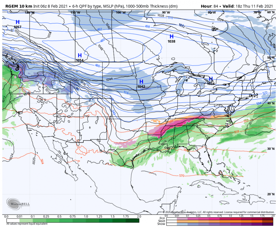
RGEM is a huge sleet storm.
Maybe short-range models will start to sniff out this dense air mass and pickup on the potential faster than the globals will.
-
10 minutes ago, BornAgain13 said:
FWIW , the ICON is an ICE Storm for the CAD areas Friday/Saturday
Yes, just now looked at that. ICON seemed to do really well with the weekend storm, maybe it's on to something. It actually dropped temps in the Catawba Valley area about 4-5 degrees from 6z.
-
Just now, tarheelwx said:
Totally agree here. I've seen 1020 get it done before (but not by much).
TW
Yeah i think 1034 can get it done, especially if it would happen to drop on in to Western NY or Western PA around that time. I like the look of the reinforcing highs building into the Midwest as well. Only time will tell but I could definitely see a few more degrees as the models tend to struggle with this dense air mass and should correct more as we get into tomorrow and Wednesday. I really like the Sun-Tuesday timeframe, I believe we could see some major CAD sinking exceptionally far south.
-
42 minutes ago, BullCityWx said:
Wouldn't take much adjustment to make that map look a little better. I think this time frame will trend colder for sure so we shall see.
-
Hrrr, did great with showing this band.

-
51 minutes ago, calculus1 said:
I'm calling it 2.5 inches for MBY.
Beautiful snowfall from about 9:30 until...
I went to bed around 1:00 and it was still snowing nicely.
Such a pleasant surprise from what usually happens: We busted high!
Sent from my moto e5 supra using Tapatalk
I measure 2.75" in Newton last night then we had a band of sleet and drizzle once we lost the best precip and lift. Probably good 1.5" after compaction and melting.
-
1
-
-
Just now, wncsnow said:
Just flurries here now, hope we can get in on some action with the pivot later. Haven't measured but looks about 1.5 just eyeballing
Yeah me too, heavier returns on the radar is falling as all snow here, but the lighter returns are drizzle/sleet mix.
-
1
-
-
Back to moderate snow here.
-
Sleet/snow mix in Newton around 2"-2.25" in the grass, neighborhood roads are covered.
-
2
-
-
3Z Hrrr picking up on the second batch of moisture bringing wintry precip back into the area by morning.
-
1
-
-
Just now, wncsnow said:
It's snowing heavy now
Looks like you will get some good totals over the next few hours. Great rates here too, we went solid snow about 9:15 maybe have 1.25-.1.5"
-
2
-
-
Heavy returns blowing up near Marion on the radar.
-
1
-
-
Really happy so far! Hrr did a good job at picking up this heavier band over the Catawba Valley.
-
2
-
-
Roads are becoming snow covered in Newton. 32.1/31
-
3
-


Mid to Long Term Discussion 2021
in Southeastern States
Posted
I bet it does, that's kind of been the theme today for that time period. Hi-res models ought to really bring that into perspective the next few runs.