jdj5211
-
Posts
266 -
Joined
-
Last visited
Content Type
Profiles
Blogs
Forums
American Weather
Media Demo
Store
Gallery
Everything posted by jdj5211
-
Snowfall NYC subforum Jan 6 and OBS if needed
jdj5211 replied to wdrag's topic in New York City Metro
we'll have to see how quick that coastal low can deepen when it gets off shore..... looks like a Monday morning to Monday evening event for the NY metro.... temps in the mid 20s throughout storm....10-1 minimum as far as ratio....could easily see 12-1 -
Snowfall NYC subforum Jan 6 and OBS if needed
jdj5211 replied to wdrag's topic in New York City Metro
GFS amped and deepening precip shield further to the north....should be a good hit coming.... -
Snowfall NYC subforum Jan 6 and OBS if needed
jdj5211 replied to wdrag's topic in New York City Metro
End of the 0z NAM run looked good.....things seem to be trending north still.....0z GFS and Euro will be telling -
doubt we'd be looking at 10-1 ratios here....it's mighty cold
-
Refresher snow & obs between ~midnight and Noon Sat Feb 17 2024
jdj5211 replied to wdrag's topic in New York City Metro
RAP still likes the heavy band in Northern NJ/NYC area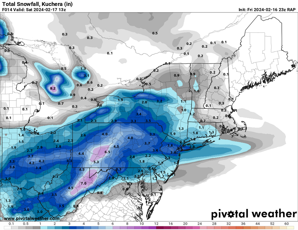
-
Refresher snow & obs between ~midnight and Noon Sat Feb 17 2024
jdj5211 replied to wdrag's topic in New York City Metro
18Z NAM Kuchura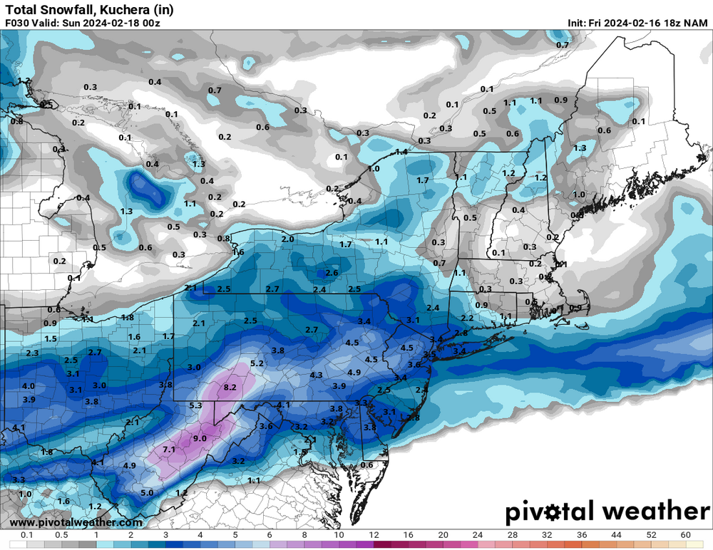
-
Refresher snow & obs between ~midnight and Noon Sat Feb 17 2024
jdj5211 replied to wdrag's topic in New York City Metro
18Z RAP is a nice hit....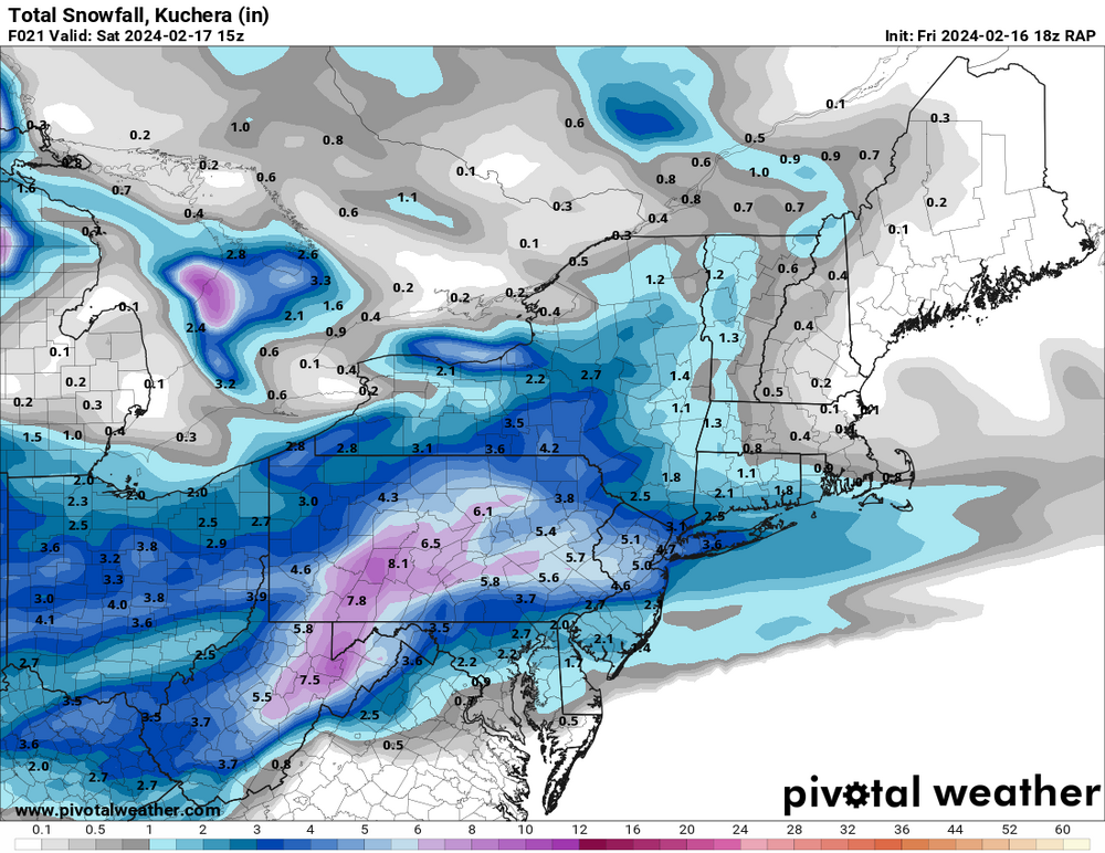
-
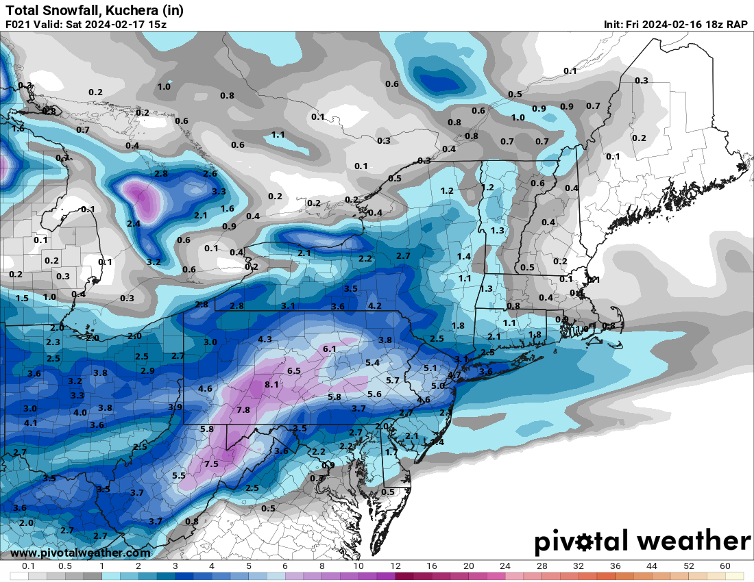
Refresher snow & obs between ~midnight and Noon Sat Feb 17 2024
jdj5211 replied to wdrag's topic in New York City Metro
Kuchura is actually showing more than the 10:1 map on most models. Being this will all fall mostly overnight with temps in the high 20s could lead to better than 10:1 in some spots -
Next chance is this Saturday
-
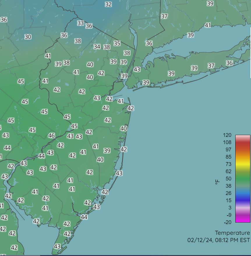
2/13 Significant/Major Winter Storm Discussion & Observations
jdj5211 replied to Northof78's topic in New York City Metro
Here are the current surface temps: Cold air is just about creeping into NW corner of NJ. We'll see how fast it can get through the region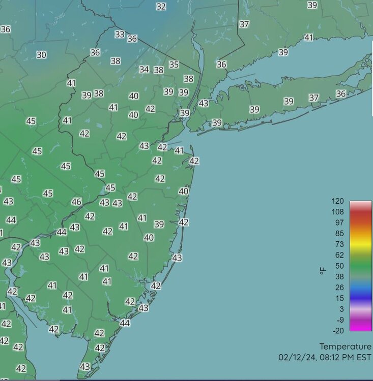
-
2/13 Significant/Major Winter Storm Discussion & Observations
jdj5211 replied to Northof78's topic in New York City Metro
RAP needs to come about 75 miles NW to be in the sweet spot. Still holding firm on heaviest axis of snow through CNJ and LI -
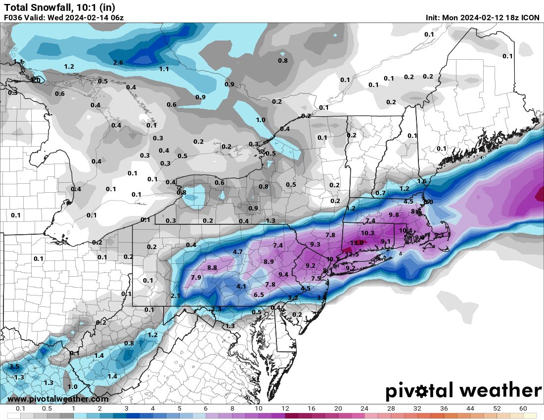
2/13 Significant/Major Winter Storm Discussion & Observations
jdj5211 replied to Northof78's topic in New York City Metro
Latest 18Z RDPS keeps heaviest snowfall right over NNJ/NYC Metro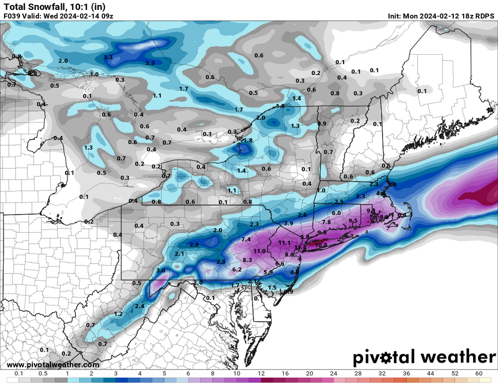
-
2/13 Significant/Major Winter Storm Discussion & Observations
jdj5211 replied to Northof78's topic in New York City Metro
Latest 18Z ICON holds heaviest snowfall axis to the north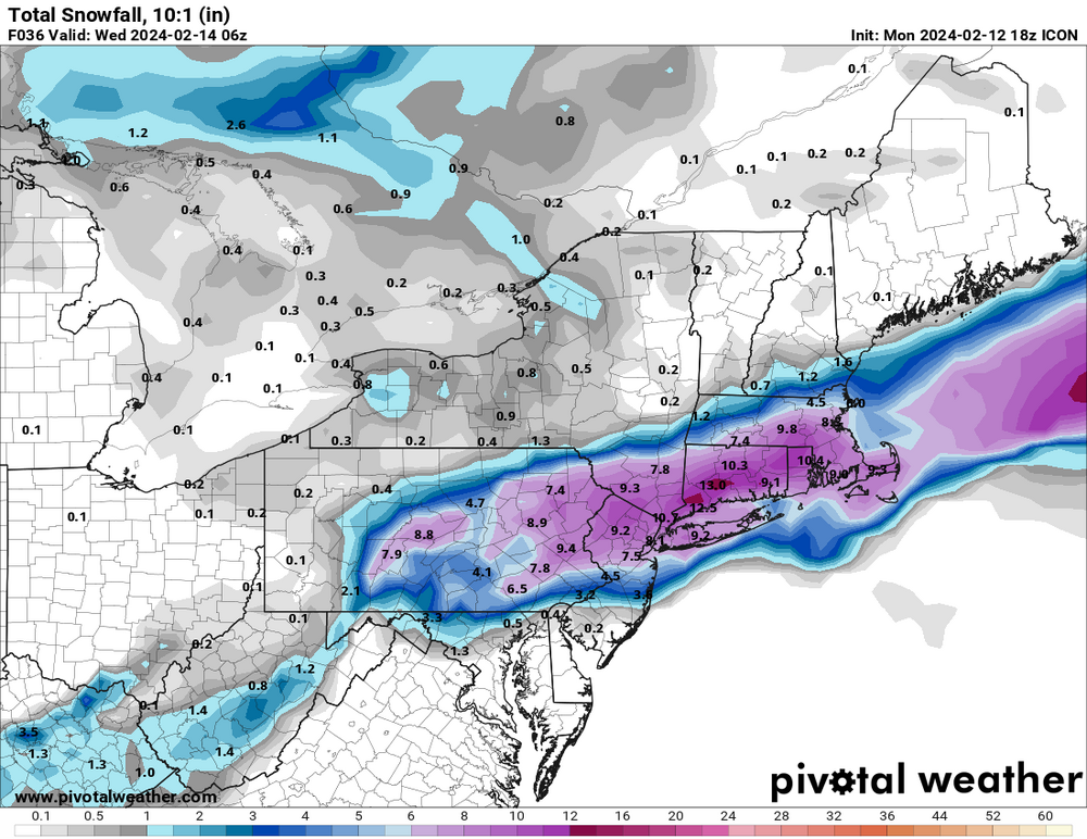
-
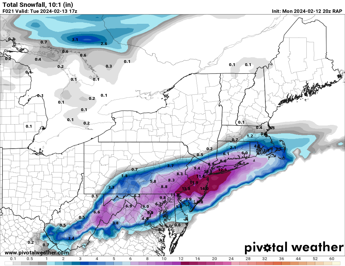
2/13 Significant/Major Winter Storm Discussion & Observations
jdj5211 replied to Northof78's topic in New York City Metro
latest 20Z RAP at 10:1 ratio....heaviest snows remain through CNJ. NY state basically a complete miss at this point
-
2/13 Significant/Major Winter Storm Discussion & Observations
jdj5211 replied to Northof78's topic in New York City Metro
This is literally a 6-7 hour storm, it's moving very quick. Even if you average an inch an hour, at best it's a 6 inch storm. No one is getting a foot of snow here. 3-6 is the safest call, with maybe a few 6+ lollipops in my opinion -
2/13 Significant/Major Winter Storm Discussion & Observations
jdj5211 replied to Northof78's topic in New York City Metro
Jan 29, 2022? -
2/13 Significant/Major Winter Storm Discussion & Observations
jdj5211 replied to Northof78's topic in New York City Metro
Look at the NAM 10-1 map and then the Kuchera map....notice anything? Kuchura was cutting totals 2-3 inches earlier....now it's almost identical in NNJ...models start to pick up on colder solution, trending back towards a 10-1 ratio.... -
2/13 Significant/Major Winter Storm Discussion & Observations
jdj5211 replied to Northof78's topic in New York City Metro
NAM is a big hit....can't ignore this trend now.... -
2/13 Significant/Major Winter Storm Discussion & Observations
jdj5211 replied to Northof78's topic in New York City Metro
Model temps are not an exact science....nothing is.... I'm about 4-5 degrees colder today than I was "supposed" to be....we'll see if models play temperature catchup as we get closer -
2/13 Significant/Major Winter Storm Discussion & Observations
jdj5211 replied to Northof78's topic in New York City Metro
The HRRR is interesting and certainly possible if we get a bombing 980mb low at the position. 18Z NAM running now. Time to start looking at the meso models as we get closer to the event. -
2/13 Significant/Major Winter Storm Discussion & Observations
jdj5211 replied to Northof78's topic in New York City Metro
For what it's worth, NAM goes 7-9 inches NNJ at 10:1.....probably 3-6 with marginal temps.... -
2/13 Significant/Major Winter Storm Discussion & Observations
jdj5211 replied to Northof78's topic in New York City Metro
Ah I see....WESTERN Passaic and Bergen.....I have a WSW in Morris county for 4-8 -
2/13 Significant/Major Winter Storm Discussion & Observations
jdj5211 replied to Northof78's topic in New York City Metro
6-8 in NE NJ? What are they seeing that we aren't?