

jdj5211
-
Posts
278 -
Joined
-
Last visited
Content Type
Profiles
Blogs
Forums
American Weather
Media Demo
Store
Gallery
Everything posted by jdj5211
-
GFS running...here we go!
-
I'll leave this here....
-
hate to say it (not really) but I'm not sure this is done coming west!
-
As a friendly reminder.....this had the new dropsound data in it!
-
oh baby through HR24 NAM looks nice!
-
That large western cluster can't be ignored!
-
I would do really bad things to see 3 feet of snow in my backyard....
-
Sorry but for NYC to get over 2 feet of snow we would need the low to track way closer to the coast...even with a closed off low it needs to close off way west of where it is now....I'm talking about for NYC to get the Boston numbers....
-
For NYC to get crushed we would need a 100 mile shift to the west and a stalling low off the NJ coast....highly unlikely at this point
-
Boston may be buried for weeks lol
-
euro should be nice!
-
not sure what the heck was going on with surface map on GFS but overall that was an awesome upper level trend in our favor!
-
looks like it tracked further NE but the precip shield was much more expanded
-
interesting that GFS has no overrunning snow out ahead of the storm like the NAM and others show....
-
I have a little tingle going on down there....I'm feeling a positive run in our favor! (banter of course!)
-
Just some small nowcasting...to my eye it looks like the northern branch appears much stronger on current sat compared to what the NAM had. The southern vort may be slightly west of NAM model, but overall the stream interaction looks much better. Thoughts?
-
Slightly SW of previous run at HR 48 but overall no drastic differences that I can spot. It’s not giving in.
-
HR 42 is a hair to the west but precip shield is non existent….
-
Not a great look through HR30
-
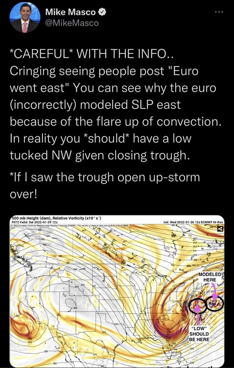
This is going to be a bit of a nowcast event like many of our big storms. Small shifts bring big differences. How many storms have we seen shift to monsters or nothing within 24 hours?! I still feel this is going to be a tucked in crawling if not stalling low that brings a widespread 12-24 to the entire sub forum. These models are chasing the rising motion under the eastern intense vorticity and causing this “eastward” thought, when in reality it’s not the case. In my opinion. GAME ON!
-
You see how the NAM had 2 lows and initially followed the eastern low but then at HR 54 it jumps back to the western low. If it followed that western low track this is a monster run for everyone. Especially those NW of NYC. Keep an eye on that! There’s so much deepening going on that it’s having a hard time figuring out the low position. This is where the 500mb track comes in and it looked good!
-
-
So basically overrunning lead snows start moving in Friday night and by Saturday morning there's 3-6 inches on the ground before the fun begins!
-
she's gunna blow!
-
One of my favorite things you've said and I consider you one of the more knowledgeable people in this forum! I haven't been this pumped up for a storm in a long time...probably since Boxing Day....


