
Brian D
-
Posts
3,029 -
Joined
-
Last visited
Content Type
Profiles
Blogs
Forums
American Weather
Media Demo
Store
Gallery
Everything posted by Brian D
-
Only 0.21" so far this month here. 2.18" is the avg for Nov. A very dry Oct-Nov up here. Oct was 10th driest with 0.63".
-
Ever since the 1998 super El Nino, temp profiles changed up here. After the Pinatubo eruption effect wore off in the mid 90's, it was like a switch was flipped. Urban sites aside, even rural sites show this pattern change.
-
Now that gov is open again, have data for Sept & Oct. Both on the warmer side. 5 & 10 yr trend charts for each month shown respectively.
-
Clouds here last night. Hope this eve will be good.
-
3 x-flares with 3 CME's coming together for what could be another event similar to May of last yr.
-
Busted. N flow dominates. Some sn shwrs around the Lakes.
-

11/8-11/10 First Snow and Lake Effect Event
Brian D replied to Geoboy645's topic in Lakes/Ohio Valley
I've been having snow shwrs in my area since yesterday. Dusting in town this morning. -
And so it begins (on the MN Deer Hunting opener) on Sat. YAH U Betcha! Saturday A chance of snow, mainly after noon. Mostly cloudy, with a high near 37. Calm wind becoming southwest around 5 mph in the morning. Saturday Night A slight chance of snow before midnight. Mostly cloudy, with a low around 22. Northwest wind 5 to 10 mph, with gusts as high as 20 mph. Sunday A chance of flurries. Partly sunny, with a high near 36. Northwest wind around 10 mph, with gusts as high as 20 mph. Sunday Night Partly cloudy, with a low around 20. Northwest wind 5 to 10 mph, with gusts as high as 20 mph. Monday Mostly sunny, with a high near 36. Northwest wind 5 to 10 mph.
-
Wind adv out for today for strong SW winds. Leaves are blowing around pretty good. Last few days, lots of tweety flocks, and even a few geese flocks moving through.
-
Roller coaster pattern with precip mainly confined to N areas of the sub, and some LER/S for early Nov is what it looks like. Hoping mid month will see some decent organized stuff. I have something possible for Veteran's day on the 11th, and the pattern mid month may produce something worth talking about.
-
0.63" for Oct is pretty paltry. 10th driest on record. Warm month; max 58.7 (+0.5=59.2) avg 53.9/ min 41.9(+2=43.9) avg 37.9 for 7am readings. 10th warmest Oct. BTW, MRCC no longer requires registration to use their Cli-mate tool. No more login, open to the public. https://mrcc.purdue.edu/newclimate/home
-
Not too bad. LP in the E with another weak LP moving in from the NW with some shwrs, and LER (some mix possible).
-
Unless of course I start one for my area just to throw that off.
-
Major Hurricane Melissa - 892mb - 185mph Jamaica landfall
Brian D replied to GaWx's topic in Tropical Headquarters
Prayers for the Jamaican people. Absolutely perfect storm, but when I watch the sat image, I also know death, and devastation are underway. My heart breaks for the people. -
Major Hurricane Melissa - 892mb - 185mph Jamaica landfall
Brian D replied to GaWx's topic in Tropical Headquarters
This thing could absolutely destroy Jamaica. Pray for it to go around either side, and weaken at the same time. Incredible storm! -
Sept had some notable action as far as temps, and precip, but what a slow, mellow Oct. Well, here's to a active Nov
-
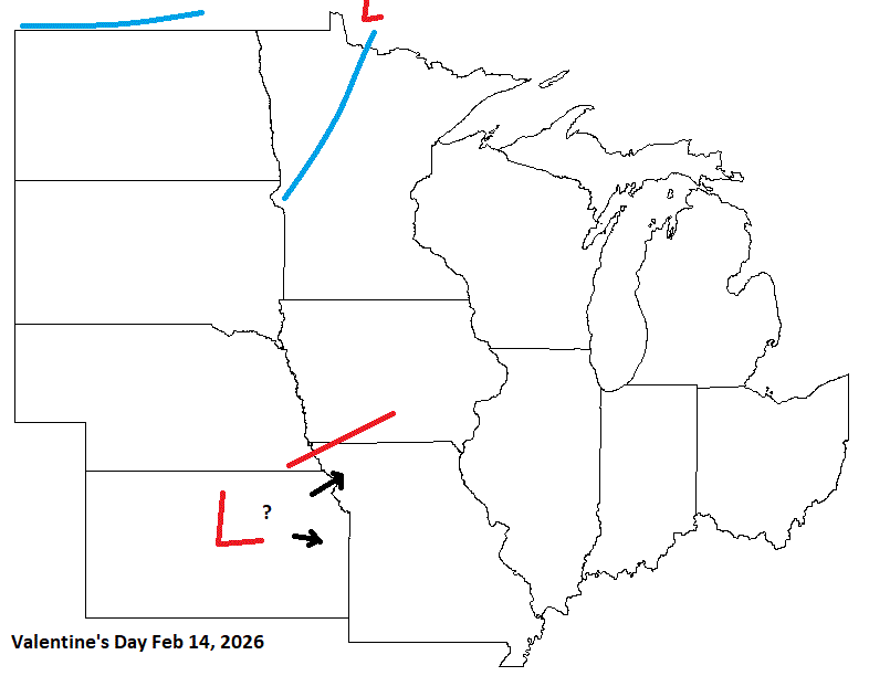
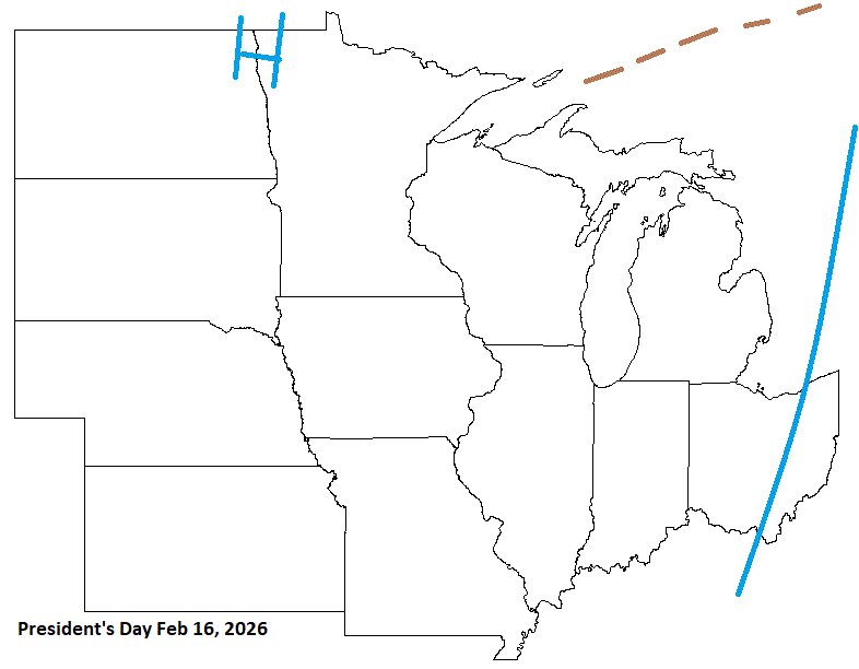
Valentine's n President's day are close this year. Stm potential with colder afterwards is possible.
-
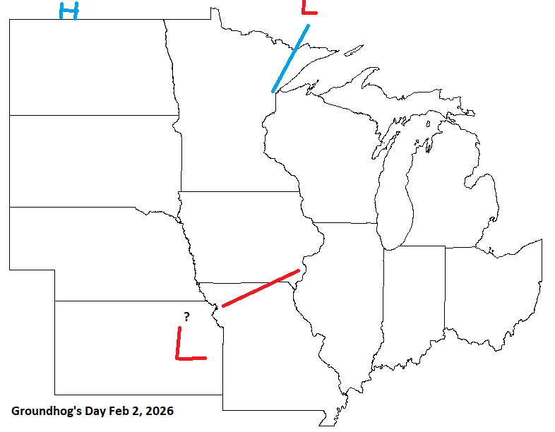
GHD timeframe needs to be watch for stm potential.
-
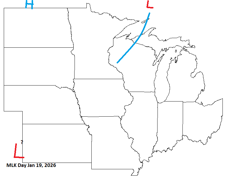
MLK day in mid Jan, I have a weak front up N, with potential energy moving in along that. Something to watch, but mid Jan does look colder, so the pattern may squelch that LP.
-
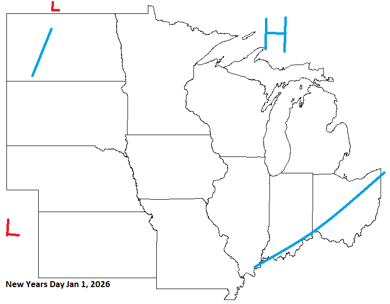
Starting 2026, looks like a CAN front/system moving through. Could be some energy riding up that prior, but by New Years day, I think HP will be over the Lakes.
-
Very cool, wet wx last couple days. Not much precip tho, just scattered shwrs here in town. 0.61" for the month so far (avg 3.03"). Nice band of LER across the Bayfield peninsula this morning. Won't be long, and I'll be updating snow totals in my sig.
-
Looking a little closer while I'm working on Holiday 2026 thread which I will post this week sometime, all 3 winter months look to have significant arctic blasts this year. How the anoms flush out will depend of course. Don't even ask about snow, that's a fickle beast. Might as well ask if your getting any from your woman this winter.
-
Maybe consider contacting a private wx org. They may have access to that kind of data they can direct you to.
-
Couple hundredths of rain last night. Pretty paltry. Temps look like they will drop next week to more avg with 45-50 on tap for highs. MN HS football playoffs start next week as well.
-
Overcast this morning with mid level stratus. Looking forward for some rain today. Been a lean month so far.


