
Brian D
-
Posts
3,029 -
Joined
-
Last visited
Content Type
Profiles
Blogs
Forums
American Weather
Media Demo
Store
Gallery
Everything posted by Brian D
-
Here in TH, Dec ended with 0.65"(avg 1.56") precip with 6.1" (avg 13.6") snow. Another drier month. Oct-Dec ranked 11th driest. Mean temp (adjusted for 7am readings) was 17.8 (36th coldest). A little colder than 2022 (18.5) which was the last colder Dec here. 2017 was 14.8, and 2013 was 9.0. TH co-op switched from pm readings to am readings Oct 2019. So some adjustment is needed in comparing. Precip for the year was 25.54" (avg 31.72") which is 38th driest out of 129 unique totals in the record.
-
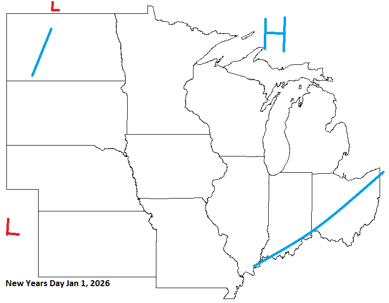
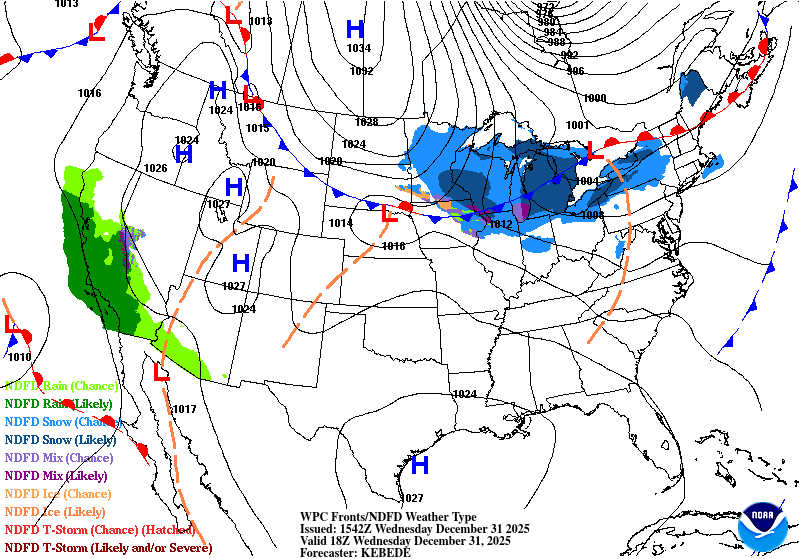
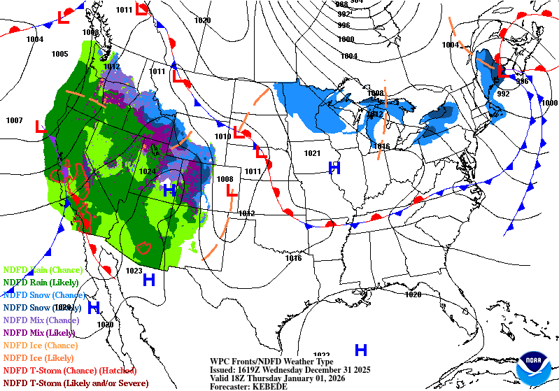
Decent forecast. Happy New Year ev1!
-
1.7" of fluff here. 1-2" across the area. Snow showers today with dropping temps.
-
Radar showing strong returns. Have flakes the size of quarters, and even some that are elongated up to 2" under calm conditions. Pretty cool
-
About an inch so far with a little more yet to go. It'll be nice to measure without drifting
-

Winter 2025-26 Medium/Long Range Discussion
Brian D replied to michsnowfreak's topic in Lakes/Ohio Valley
ZZZZ until....POP! better than POP then fizzle. -
1.0" of snow IMBY with winds up to 40 mph last night. They're kicking back up this morning to 35 mph. Around my area just 1-2" of snow. Nice hit from S MN into the UP MI.
-
Snow finally filled in along the shore. Starting to accum now.
-
Getting robbed. Snow staying just offshore, but is filling in around DLH. Just FL here in TH. Was expecting this possibility. We'll see if it fills in a little more as the day wears on, and I get something to measure tonight.
-
I'm on the N edge with low expectations. N/NW wind with NE 850mb will keep the Lake hammer just to my S. A little syn of 3" (3-7" forecasted for TH) is all I'm expecting. WSW issued because of blowing with 30-40+ mph winds. Just a little more of a jog N, and I'd be golden. They also have Wind adv & High wind warning along the shore as well.
-
Guess they will have to look at sat images/radar data to see if there was any convection going on at the time. There can be a fine line between hail or sleet sometimes. The whiteness of the graupel could easily be partially melted snow that refreezes. Most sleet I've seen is mostly clear, tho, so more data would be needed to make that call. It can be an easy mistake this time year.
-
Looks like a good hit Sun night. Not so sure if it'll be that great my way. Might hit min guidance. S of me will do really well with Lake enhancement/LES, tho. Then another strong shot of bitter air for the week.
-
Thankfully nothing major with the frz rn yesterday. Just some off n on sprinkles/-rn imby. Some light ice reports of 0.1" or less, with 1-2" of snow across Cook county.
-
Merry Christmas n a Happy Holiday to all. Light frz rn mixed with some snow forecast for later today with some snow along the border. Untreated surfaces will be slick.
-
Did my boot camp in 1987 in Ft Sill, OK in the middle of summer. That was nasty! Then another 2 months there for more training in Jan-Feb 1990. Wild wx there with highs in the 80's down to 10's after a blue norther, and 6" of slush snow. And in 1990 spent 2 months (Oct-Nov) over in Albuquerque helping with some testing at Kirkland AFB. Never seen so many tumbleweeds, and absolutely dry wx for weeks. 10% humidity many days. One of the guys had a friend over in Dallas, so we spent Thanksgiving with him, and his family. Was glad to have experienced a different part of our country that is so much different than up N.
-
Decent call here for the pattern. Nothing to disrupt Christmas travel too much. Some wet wx in the S sub on Wed, and a LP moving in from the W will bring some sloppy wx on Thurs eve in to Friday. Merry Christmas ev1! Hope your holiday's are blessed
-
Christmas Day eve into Friday may be a wet snow, icy system for N MN - N WI (& UP MI). Looks like I did a decent job with the Holiday forecast in sniffing out the pattern.
-
Winter 2025-26 Short Range Discussion
Brian D replied to SchaumburgStormer's topic in Lakes/Ohio Valley
Christmas Day may be a LES or lake enhancement with synoptic snows across NE MN. Looks like a possible def zone between HP n LP setting up. A long fetch from the ENE across the Lake usually gives something, especially with a boundary hanging out. -
0.4" of snow from the clipper. Now this morning winds are kicking up into the 30's blowing snow around. Temps were in the mid 20's and in just a half hour dropped to mid teens. Cold day on tap.
-
0.5" IMBY of snow after a rainy day yesterday, and bitter temps this morning under clear, blue skies n fairly calm winds. -sd's near the Lake with -10's/-20's across inland NE MN. I-Fall's dropped 56dF in 26hrs from 34 to -22.
-
TBH, science is almost always corrupted by money n politics to some degree. Going to have to leave it there.
-
Rain showers this morning making things nice, and sloppy(and a bit icy on untreated surfaces). High wind watch along the shore later today for potential gusts to 60 mph.
-
S trend would be nice. LP will track right over me at this point.
-
Is 6-9" a big snow? The upper end of that is getting there. Maybe we need a woman's perspective on this??
-
Winter 2025-26 Short Range Discussion
Brian D replied to SchaumburgStormer's topic in Lakes/Ohio Valley
Pretty much lighter snows, and gusty winds for the foreseeable future. Might get lucky with some lake enhancement/LES. Temps will be a rollercoaster ride.


